November Overview
Never doubt that this author can find something interesting associated with the weather and climate of any month or season. However, truth be told, sometimes what transpires does not rise to the level of exceptional interest among those not infected with the weather bug. For the most part, this report’s title holds true for this November and fall. Certainly, there was many a gusty day this past month. Also, drought concerns failed to abate in a season where each month saw below normal statewide precipitation, making it 13 of the past 15 months with deficient precipitation. However, despite low precipitation totals, there were many dull, cloudy November days, New Jersey’s fall (fortunately) escaped any tropical storms, and just one notable early-season coastal storm occurred, albeit generating coastal flooding with associated damage. Next is a discussion of November conditions, followed by a brief recap of fall precipitation and temperature statistics.
November precipitation, virtually all in the form of rain, averaged 1.88” across NJ. This was 1.48” below the 1991–2020 mean and ranked 23rd driest of the past 131 years. The northern climate division (Hunterdon/Somerset/Union and northward) averaged 1.87” (-1.60”, 22nd driest), the southern division (Mercer/Middlesex/Monmouth southward, except east of the Garden State Parkway) 1.91” (-1.38”, 33rd driest), and the coastal division (east of the Parkway) 1.70” (-1.64”, 26th driest). The far northwest and far south were driest. Wetter totals, though still below average, were found along the Turnpike corridor and in portions of Central NJ (Figure 1).
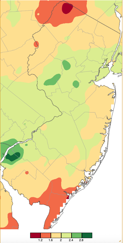
Figure 1. November 2025 precipitation across New Jersey based on a PRISM (Oregon State University) analysis generated using NWS Cooperative, CoCoRaHS, NJWxNet, and other professional weather station observations from approximately 8 AM on October 31st to 7 AM on November 30th. Note the scale in inches at the bottom of the map. Totals range from 0.80”–1.20” (dark red) to 2.80”–3.20” (dark green).
Snowfall was meager, with some locations not seeing a flake and others not even a dusting. Despite some measurable totals in parts of the north, the statewide average was 0.0”. This was 0.4” below normal and ranks as lowest of the past 131 Novembers, joining 55 other years. The northern snow zone (Warren/Morris/Essex/Hudson northward) averaged 0.1” (-0.8”, 53rd least snowy: tied with 10 other years), the central zone (Hunterdon/Somerset/Union/Middlesex/Monmouth/Mercer) averaged 0.0” (-0.6”, tied with 64 other years), and the southern zone (Burlington/Ocean southward) averaged 0.0” (-0.1”, tied with 95 other years).
The November statewide average temperature of 44.7° was 0.4° below normal, ranking as the 46th mildest on record. The average high was 54.1° (-0.6°, 49th mildest) and the average low was 35.3° (-0.2°, 42nd mildest). The north averaged 42.7° (-0.4°, 44th mildest), the south 45.8° (-0.5°, 47th mildest), and coast 47.0° (-0.3°, 46th mildest).
Precipitation and Storms
Rain and melted snow amounted to as much as 2.73” at Bedminster (Somerset County) for the largest November total at any Rutgers NJ Weather Network (NJWxNet) or NJ Community Collaborative Rain, Hail, and Snow Network (CoCoRaHS) station. This was followed by 2.58” at both Peapack-Gladstone (Somerset) and Sicklerville (Camden), Wenonah (Gloucester) 2.54”, Flemington (Hunterdon) 2.49”, Woodstown (Salem) 2.49”, and Springfield Township (Union) 2.49”. The lowest totals included 1.02” and 1.06” at two Ocean City (Cape May) stations, two Somers Point (Atlantic) stations with 1.09” and 1.21”, West Cape May (Cape May) 1.14”, and Woodbine (Cape May) 1.14”. Stations with complete daily snow reports for the month were topped by 0.7” at Sparta Township (Sussex), West Milford (Passaic) 0.6”, and Randolph Township (Morris) 0.5”.
Little rain fell in the first week of the month, with under 0.20” at some south coast locations on the 3rd and less than 0.25” in northern and southern areas on the 7th into the 8th. More substantial rain fell in daytime and evening showers on the 9th that ended before dawn on the 10th. Woodstown came out on top with 1.04”, followed by Wenonah 0.84”, West Deptford Township (Gloucester) and Lebanon (Hunterdon) each with 0.77”, and 0.50”–0.76” at 56 of the 264 CoCoRaHS reporting sites (Figure 2).
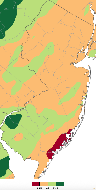
Figure 2. Precipitation across New Jersey from 7 AM on November 8th through 7 AM November 10th based on a PRISM (Oregon State University) analysis generated using NWS Cooperative, CoCoRaHS, NJWxNet, and other professional weather station observations. Note the scale in inches beneath the map.
Midday rain squalls on the 10th brought as much as 0.38” to West Caldwell (Essex) and 0.34” at Livingston (Essex). Rain returned late on the 7th, ending before dawn on the 8th, though top totals were only 0.44” in Blairstown Township (Warren) and 0.43” at Jefferson Township (Morris). Precipitation fell from predawn through the morning on the 19th. Of 272 CoCoRaHS reports, rainfall amounted to as much as 0.91”, 0.80”, and 0.78” at three Galloway Township (Atlantic) sites, Little Egg Harbor Township (Ocean) 0.73”, Port Republic (Atlantic) 0.73”, and 30 sites between 0.50” and 0.73”. Snow fell at higher elevations in the north, accumulating to 0.7” in Sparta Township, with Mine Hill Township (Morris) and Schooley’s Mountain (Morris) each picking up 0.4”. The 22nd found morning rain amounting to as much as 0.45” at Egg Harbor City (Atlantic), Pitman (Gloucester), and Little Egg Harbor Township.
The most substantial precipitation event of November, all falling as rain, occurred from the afternoon of the 25th into predawn on the 26th. Still, like the 9th–10th event, only one station recorded more than 1.00”, this being 1.11” at Watchung (Somerset). Elsewhere, of the 269 reports, Lincoln Park (Morris) caught 0.98”, Morristown (Morris) 0.97”, Harrison (Hudson) 0.94”, and 158 locations 0.50”–0.91” (Figure 3).
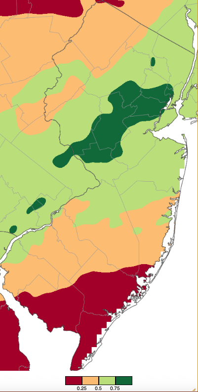
Figure 3. Precipitation across New Jersey from 7 AM on November 24th through 7 AM November 26th based on a PRISM (Oregon State University) analysis generated using NWS Cooperative, CoCoRaHS, NJWxNet, and other professional weather station observations.
Later on the 26th, frontal showers deposited as much as 0.50” in Medford Township (Burlington) and 0.45” at Moorestown (Burlington). The final precipitation event of the month occurred during the midday hours of the 30th. Thus, as those who frequently read these reports know, the rain and snow measurements do not count toward November totals, as because this was past the standard morning hours, they will be applied to December totals. Still, it is worth reporting that modest amounts of rain brought as much as 0.46” to Maurice River Township (Cumberland), 0.42” in Middle Township (Cape May), and 0.37” at two Woodbine sites. Up north, 0.5” of snow fell at High Point Monument, Randolph Township 0.3”, Sparta Township and Frelinghuysen Township (Warren) each with 0.4”, and Blairstown Township 0.3”.
Despite not seeing particularly large precipitation totals from any storm during November, on multiple occasions New Jersey was “squeezed” between regions of low and high pressure. This resulted in an impressive total of 11 days seeing wind gusts of 40 mph or greater at one or more NJWxNet station. Rather than looking at them piecemeal over the preceding event narratives, with some windy days not seeing any precipitation at all, here they are recapped together. On the 1st, Wantage (Sussex) gusted to 48 mph, High Point Monument (Sussex) 42 mph, and High Point (Sussex) 41 mph. High Point Monument reached 42 mph on the 3rd. The 5th brought a 55-mph gust to the Monument, with Little Egg Harbor Township at 52 mph, Lower Alloways Creek Township (Salem) 51 mph, Moorestown 50 mph, and eight NJWxNet stations from 40–47 mph. Lower Alloways Creek Township peaked at 51 mph on the 6th, with nine stations from 40–49 mph.
High Point Monument reached 40 mph on the 10th. Fortescue (Cumberland) and Little Egg Harbor Township gusted to 50 mph on the 11th, with nine stations from 40–49 mph. Little Egg Harbor Township reached 42 mph on the 13th. The 16th was exceptionally windy, with High Point Monument at 54 mph, Little Egg Harbor Township 50 mph, eight stations from 45–49 mph, and 14 locations from 40–44 mph. The 17th found Little Egg Harbor Township up to 49 mph and six stations from 42–45 mph. Finally, on the 27th Seaside Heights (Ocean) gusted to 40 mph, and on the 28th High Point Monument reached 47 mph and three locations 41 mph.
Fueling some of the winds were atmospheric pressure values as low as 29.15”–29.25” on the 16th and as high as 30.45”–30.55” on the 29th.
The last weekly US Drought Monitor map of the month on the 25th showed areas of Severe Drought (D2) in the northwest and southwest. These conditions arise approximately every 10–20 years (Figure 4). Elsewhere, much of the western half of the state was designated D1 (Moderate Drought), with D0 (Abnormally Dry) further east, and no dry designation closer to the coast.
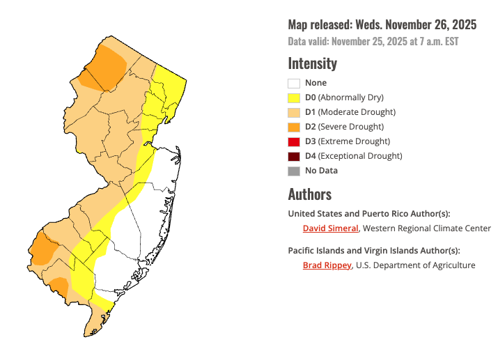
Figure 8. U.S. Drought Monitor map of conditions in NJ as of November 25th (National Drought Mitigation Center).
Temperature
High temperatures reached 60° or higher at one or more of the 69 NJWxNet stations on 14 November days. Six of these days included highs of at least 65°. The first of these was the 2nd, with Lower Alloways Creek Township up to 68°, 19 stations from 65°–67°, and 35 from 60°–64°. The 5th found West Deptford Township at 71°, seven stations 70°, 44 from 65°–69°, and 11 from 60°–64°. The 8th was the month’s warmest day, with Lower Alloways Creek Township 71°, ten stations 70°, 44 from 65°–69°, and eleven 60°–64° (Figure 5). On the 9th, Woodbine reached 70° and 58 stations from 60°–69°. Vineland (Cumberland) hit 66° on the 16th, when 40 stations mad it to 60°–65°.
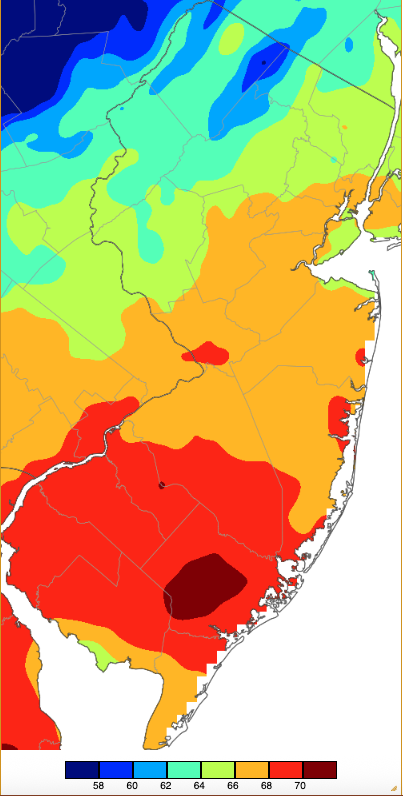
Figure 5. Maximum temperatures on November 8th based on a PRISM (Oregon State University) analysis generated using NWS, NJWxNet, and other professional weather stations. Note the 2° scale beneath the map.
On the 26th Cape May Court House (Cape May) made it to 69°, with 45 locations from 60°–67°. On the 6th, there was a 20° difference between highs of 62° at five stations and 42° at High Point Monument. A diurnal range of 34° occurred at Walpack (Sussex) on the 3rd, with this location tied on this day for the highest state maximum of 62° and having the state minimum of 28°. High Point Monument failed to make it past 30° on the 11th and 32° on the 29th, for the only two daylong freezing days thus far this season.
Twenty-seven November days found one or more station with a low of 32° or colder. Only the 8th, 9th, and 26th missed the mark. Of the 27 days, 12 saw one or more stations with a low between 20°–24°, without any November daily low falling into the teens. The first of the 12 was the 7th, when Walpack reached 21° and 52 stations dropped to 22°–32°. This was the first day with over half of the NJWxNet stations below freezing, although Harvey Cedars (Ocean) only fell to 43°. HPM fell to 24° on the 10th. A more widespread freeze occurred on the 11th, with High Point Monument at 21° and 59 stations from 24°–32°. The next sub-25° minimum was on the 14th when Hopewell Township reached 24°. Walpack fell to 20° on the 15th, with Sandyston (Sussex) at 23° and 28 locations from 26°–32°. Walpack took sub-25° honors on the 18th, 19th, and 20th, with 45 other stations below freezing on the first day, 18 on the second, and 34 on the third. Walpack again came in coldest at 20° on the 23rd, with eight locations from 21°–24° and 53 from 25°–32°. Atlantic City Marina (Atlantic) and Harvey Cedars were mildest at 38°.
At month’s end, Hackettstown (Warren) fell to 24° on the 28th with 53 locations from 25°–32°. The 29th had a cold morning but it was not until the evening that most daily lows occurred. This coldest November day found Berkeley Township (Ocean), Hackettstown, Pequest (Warren), and High Point Monument all with 22° lows, five stations at 23° or 24°, and 58 from 25°–32° (Figure 6). Only Jersey City (Hudson) and Lyndhurst (Bergen) remained above freezing, each at 33°. Hopewell Township fell to 24° on the 30th.
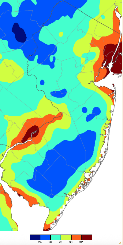
Figure 6. Minimum temperatures on November 29th based on a PRISM (Oregon State University) analysis generated using NWS, NJWxNet, and other professional weather stations.
It was not until the 29th that four stations in the NJWxNet recorded their first freezing low of the season. This includes Atlantic City Marina, Little Egg Harbor Township, Fortescue, and Lower Alloways Creek Township, all situated within a stone’s throw of water bodies that are slow to cool come fall. Earlier, other locations near water saw their first freeze, including Harvey Cedars and Seaside Heights on the 11th and Lyndhurst and Newark Airport (Union) on the 23rd.
As is often the case each year, the length of the 2025 growing season (defined as the number of days between the last freeze of the spring and first fall freeze) varied significantly across New Jersey. This year, as is often the case, Walpack had the shortest growing season within the NJWxNet of 153 days. The last spring freeze at this northwest valley station was May 1st and the first fall freeze on October 2nd. The longest growing season was at Lower Alloways Creek Township on Delaware Bay. The 269-day season there was 116 days longer (almost four months longer!) than at Walpack, with the last spring freeze was on March 4th and first fall freeze on November 29th.
Winds do not have to blow as strongly as those discussed earlier in this report to have an impact on weather conditions. While the example given here is considerably more subtle than a crashing tree limb or leaves whipping around, it depicts the impact even a light breeze can have on temperatures near the surface. On relatively calm clear nights, colder air can settle within tens of feet of the surface, leaving milder, less dense air higher off the ground. However, if even a light wind develops, the atmosphere can quickly experience a mixing of the milder air aloft with the cooler air below. This can cause temperatures being recorded close to the surface at the standard height of 5.5 to 6 feet to increase. Such a situation was strikingly evident in the late evening of November 13th and early morning hours of the 14th at the Hillsborough-Duke (Somerset) NJWxNet station (Figure 7). Notice that the temperature variations in the top graph (blue line) fluctuated by more than 10° on two occasions. The wind graph below confirms that when the temperature declined, winds (hourly averages and hourly peak values) were below or close to 5 mph. When speed increased, with averages rising to over 5 mph and gusts to 10 mph or a bit higher, the temperature rose. Meanwhile, dewpoint temperature variations were not as pronounced as air temperature, suggesting the moisture content of the air at different heights did not vary too much. There is always something interesting for weather buffs within NJWxNet maps, tables, and graphs!
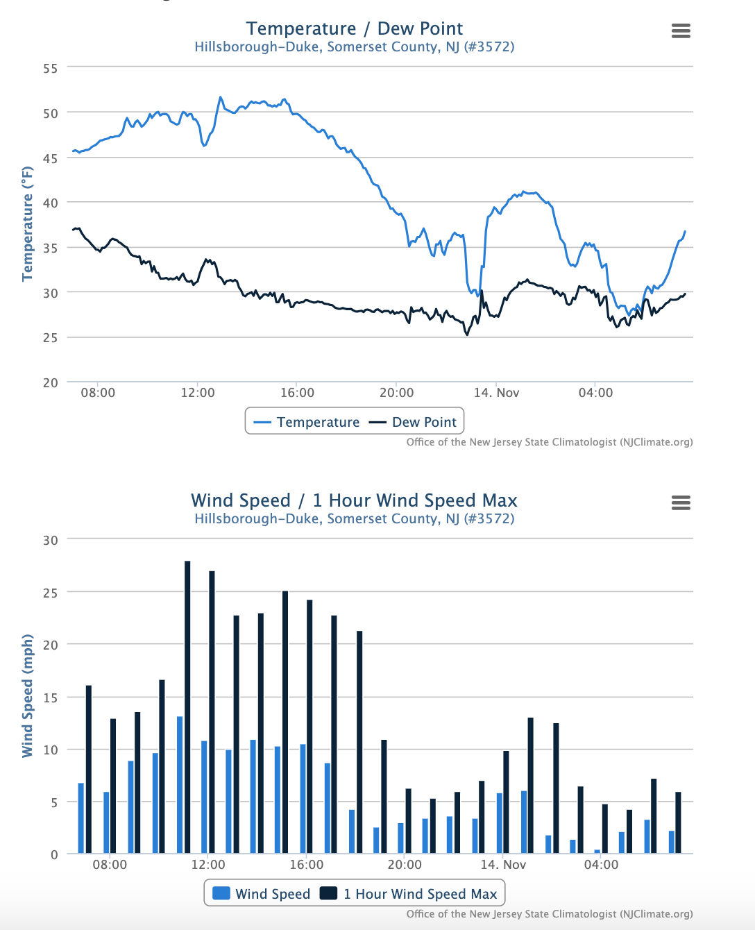
Figure 7. Time series of temperature and dew point (top) and average hourly wind speed and hourly wind speed maximum (bottom) at the Hillsborough-Duke NJWxNet station from 7 AM on November 13th to 7 AM November 14th.
Fall 2025 Overview
Statewide fall precipitation averaged 7.99”. This was 3.72” below the 1991–2020 average and ranks as the 29th driest of the past 131 years. At least it was wetter than last year’s record low total (3.36”) that was 8.35” below normal. Still, as was discussed above, New Jersey is continuing to face drought conditions that have been varying in magnitude since fall 2024. Thirteen of the last 15 months have had below normal totals, with all of NJ under a Drought Watch (NJ Department of Environmental Protection) as fall ends. Note: as this report was in its final state of preparation on December 5, the Watch was elevated to a statewide Drought Warning. The next step would be a Drought Emergency, currently not imminent and not seen in NJ since 2002.
Northwest and southwest Jersey received the least fall precipitation (Figure 8), witness the worst drought conditions in these locations as depicted in Figure 4. The driest stations this fall included Salem (Salem) with 5.76”, followed by Liberty Township (Warren) 5.85”, Blairstown Township (Warren) 5.98”, Frelinghuysen Township (Warren) 6.07”, and Newton (Sussex) 6.34”. The northern and central coast received the most fall rain. Little Silver (Monmouth) caught 13.41”, Stafford Township (Ocean) 12.80”, Lacey Township (Ocean) 12.73”, Eatontown (Monmouth) 12.34”, and Neptune City (Monmouth) 12.16”.
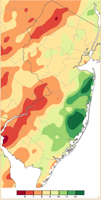
Figure 8. Fall 2025 precipitation across New Jersey from 8 AM on August 31st through 7 AM November 30th based on a PRISM (Oregon State University) analysis generated using generated using NWS Cooperative and CoCoRaHS observations. Note the scale in inches beneath the map.
Fall temperatures across the state averaged 56.3°. This was 0.5° above normal, ranking as the 24th warmest. The highest temperatures reached across during the season are mapped in Figure 9. The lowest temperatures, almost all occurring on November 29th, are shown in Figure 10.
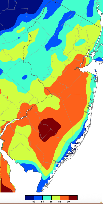
Figure 9. Extreme maximum temperatures during fall 2025 (September 1st–November 30th) based on a PRISM (Oregon State University) analysis generated using NWS, NJWxNet, and other professional weather stations. Seasonal maximum temperatures occurred on different days at different locations.
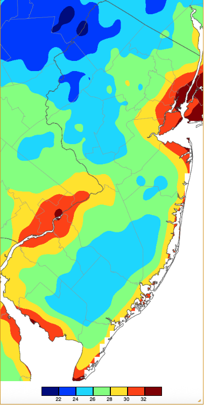
Figure 10. Extreme minimum temperatures during fall 2025 (September 1st–November 30th) based on a PRISM (Oregon State University) analysis generated using NWS, NJWxNet, and other professional weather stations. Seasonal minimum temperatures occurred on different days at different locations.


