Blog

Seasonal Trends in Extreme Minimum Temperatures at Six New Jersey Locations
February 1, 2018 - 4:49pm -- Joey Fogarty

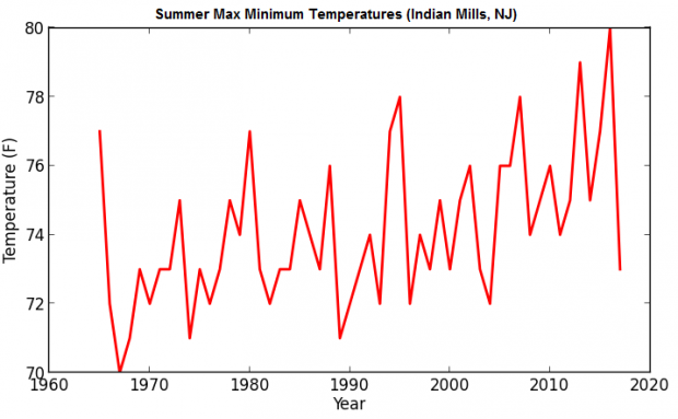
Indian Mills Max Min Temps

Data have been collected from multiple NJ stations over a long period of time, some dating back to the nineteenth century. With this amount of data, we can perform a multitude of analyses on different variables, such as daily maximum or minimum temperature.

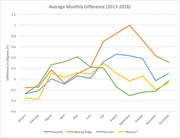
In this brief report, we examine seasonal maximum minimum temperature (that is, the highest daily minimum temperature in a meteorological season) and the seasonal minimum minimum temperature (the lowest daily minimum temperature in a meteorological season). Each of these values has potentially important ecological and human health impacts. For instance, an increase in the lowest minimum may permit the eggs of insects, such as the Southern Pine Beetle, to survive winters in regions where colder temperatures in the past prohibited survival. This beetle has already invaded the New Jersey Pinelands, and threatens to do considerably more damage.

What a Weak La Niña Event Might Have in Store for New Jersey this Winter

January 12, 2018 - 3:00pm -- Ariel Schabes

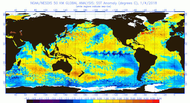
As some of you may remember, last winter there was a weak La Niña event in the tropical Pacific that followed a strong El Niño in 2015. As most past La Niñas have suggested, due to remote influences on circulation across North America, the winter 2016/17 snowfall in New Jersey was not abundant. Here we are again in a weak La Niña situation as the heart of the 2017/18 winter approaches. Thus far, snowfall is above average, but clearly it is too early to say if this season will end up with a surplus or deficit of the white stuff.

What exactly is a La Niña? Like an El Niño, a La Niña is associated with anomalous atmospheric trade winds and ocean circulation in the tropical Pacific. While an El Niño involves a weakening (or even reversal) of westerly (east to west moving) trade winds along the equator and resultant warming of waters in the eastern equatorial Pacific, a La Niña event essentially involves an enhancement of the more common ocean and atmosphere circulation regimes.

A Better Approach to Calculating Daily Mean Temperature

June 16, 2017 - 3:18pm -- Eric Davis

The convention of the weather and climate community has been to calculate the observed daily mean temperature by summing the maximum and minimum instantaneous temperatures during a 24-hour period and dividing by two. However, does this recording method capture and represent the true average temperature over the course of a day? This conventional approach fails to integrate significant behaviors of temperature associated with rapid weather events, frontal passages, sea breezes, and even seasonal temperature variations. It is possible that sampling more frequently and finding a more representative value for daily temperature averages will reveal patterns in which the daily mean temperature skews towards the daily maximum or minimum (i.e., the full-day average temperature is more often closer to the daily maximum or the daily minimum).

Princeton-Area Deluge on July 30 an Extremely Rare Event

August 31, 2016 - 4:57pm -- Mathieu Gerbush

Radar image

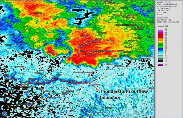
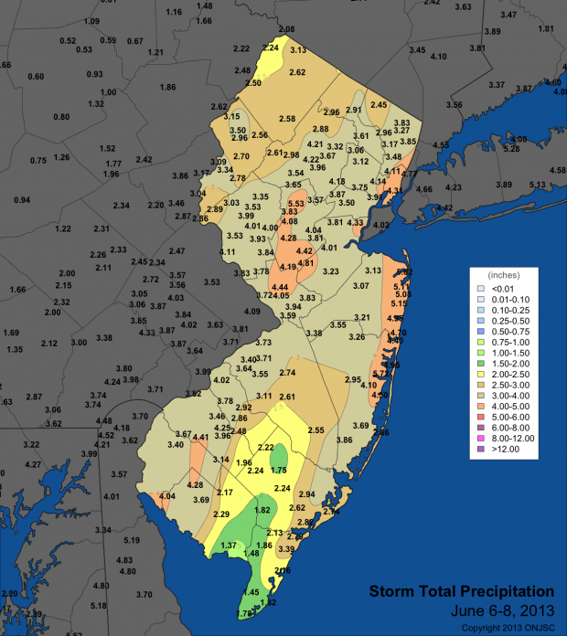
The several-hour-long downpour that drenched parts of Mercer and Middlesex County on the afternoon of July 30, 2016, represented an exceptionally rare event for the area. Afternoon and evening thunderstorms dropped 7.23” in West Windsor (Mercer County), with Plainsboro (Mercer) reporting 5.15”, South Brunswick (Middlesex) 5.03,” and North Brunswick (Middlesex) 4.90”. These rainfall totals were measured by volunteer weather observers in the Community Collaborative Rain, Hail, and Snow (CoCoRaHS) network, providing vital precipitation data that would otherwise be nonexistent. The bulk of the rainfall occurred during a roughly 3-hour period from 2:45 PM through 5:45 PM, with the most torrential rainfall occurring along and just south of Route 1 from Princeton Junction (West Windsor Twp.) east northeast to Monmouth Junction and Dayton (South Brunswick Twp.).

Exploring a Possible Relationship Between Snow Cover Duration and Air Temperature at the New Brunswick, NJ, Cooperative Weather Observing Station

August 15, 2015 - 10:58pm -- Hans Moeller

Figure 1

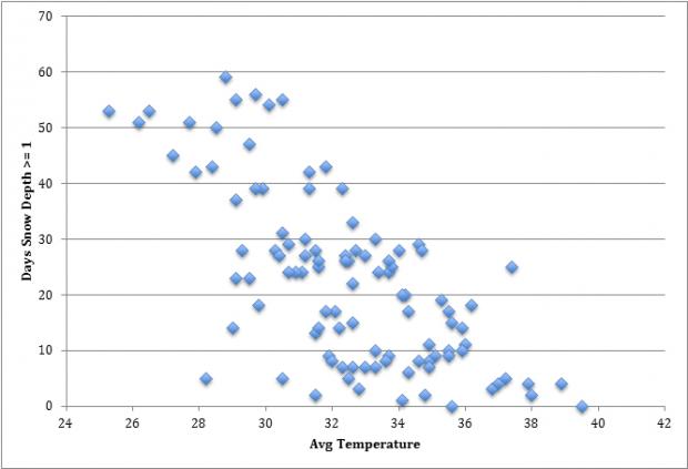
This past winter, snow covered the ground in northern and central New Jersey from the last week of January through mid-March. This long duration of snow cover was accompanied by colder-than-average conditions. This got me wondering whether there is a strong relationship between the two variables. We hypothesize that there is an inverse relationship between temperature and number of days of snow cover during New Jersey winters.

I chose to test this hypothesis using daily data from the National Weather Service Cooperative Weather Station in New Brunswick, NJ. Data were retrieved from the SC ACIS 2 website maintained at the Northeast Regional Climate Center and exported into an Excel file for analysis. From daily observations of maximum and minimum temperature, a seasonal mean temperature was computed for December through February each winter from 1914 – 2015. An early-morning observation of snow on the ground is made daily at the station. For this study, the number of days with the depth exceeding 1”, 2”, and 4” were computed for December – February. The number of days with snow above these different thresholds were plotted against temperature to facilitate analysis.

Rutgers Students on the Prowl for Tornadoes

August 25, 2014 - 12:48pm -- Colleen McHugh

Storm Chasing Photo 2

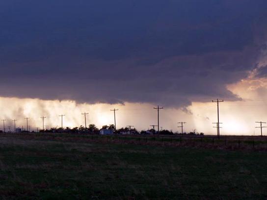
From May 28 to June 10, 2014, 15 aspiring meteorologists from Rutgers University headed on a journey to the central US on the hunt for tornadoes. This trip was a Rutgers course designed to teach students how to forecast severe weather, and actually witness severe storms first hand, with the possibility of seeing a tornado. Tornado chasing popularity has been on the rise because of popular TV shows like Discovery Channel’s “Storm Chasers” and the 1996 movie “Twister.” The media portrays storm chasing as a thrilling adventure, filming scientists and weather enthusiasts that often become overwhelmed by the atmosphere around them. I can personally say that storm chasing can provide an adrenaline rush. However, for meteorologists and students there is also scientific legitimacy behind these chases. Severe thunderstorm and tornado field research is essential in order to gather data to better understand these storms and, ultimately, to save lives. For our class, we were concerned about accurately forecasting, heading out with nothing but a link to radar and a handheld anemometer/thermometer.

Welcome to the new NJ Weather and Climate Network

April 24, 2014 - 4:47pm -- Chad Shmukler

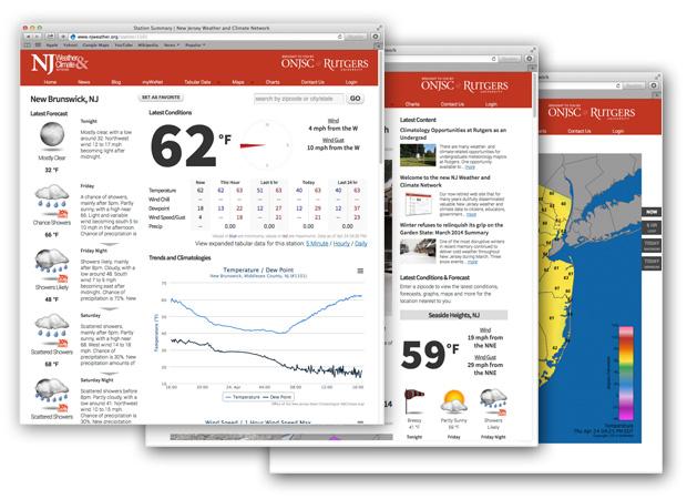
Our now-retired web site that for many years dutifully disseminated valuable New Jersey weather and climate data to citizens, educators, government officials and agencies, emergency managers and more was in need of an update. Today, we're pleased to make our new web site available to the general public for the first time. This latest incarnation of the New Jersey Weather and Climate Network, which can now be found here at www.njweather.org, includes a bevy of new features and usability enhancements.

In the coming weeks and months, we'll delve further into these new features and enhancements via blog posts introducing and detailing how to take advantage of them. For the time being, please explore the list below that briefly summarizes some of the new improvements and additions.

Climatology Opportunities at Rutgers as an Undergrad

April 19, 2014 - 2:32pm -- Colleen McHugh

New Brunswick Weather Station Photo

There are many weather- and climate-related opportunities for undergraduate meteorology majors at Rutgers. One opportunity available to undergraduates is to become a student observer at the Cooperative observing station at the Rutgers Gardens. Each morning, one student heads to the gardens at 7 or 8 AM, a rather ridiculous hour for college students, and takes measurements at the station. These measurements include the high and low temperatures over the past 24 hours, soil temperature at different depths, evaporation rate, precipitation, and snowfall and snow depth, if applicable. After recording these measurements, they are sent in to the National Weather Service and stored by the National Climatic Data Center as a part of the climatological database for New Brunswick. Taking observations is not only important from a meteorological perspective, but also from a climatological one to create averages over a long period of time.

Atypical Snow Pattern during March

April 4, 2014 - 4:23pm -- Colleen McHugh

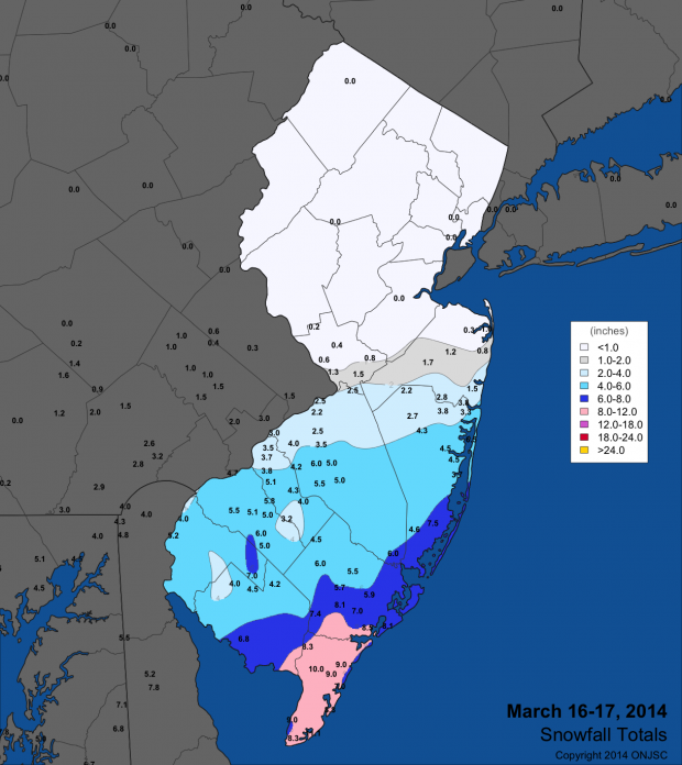
Snow map from March 16-17, 2014

Depending on where you live in New Jersey, this past month could have been extremely winter-like, or on the other hand, extremely not. March marks the beginning of meteorological spring, however the atmosphere had something different in mind. March bought several winter storms to South Jersey, while North and Central Jersey had close to no snowfall. Living in Central Jersey, the beginning to meteorological spring was less than ideal for snow lovers, with cold temperatures and essentially no snow to go along with it. This being said, the southern part of the state (comprised of Burlington, Ocean, Camden, Gloucester, Salem, Cumberland, Atlantic, and Cape May counties) had an atypically snowy March with an average of 11.8 inches of snow, while its neighbors in the central and north had 0.4 and 0.1 inches, respectively.

Pages

Subscribe to RSS - blogs