Overview
Following a cold December and first few days of the month, temperatures rose to above-normal levels through the remainder of the first half of January. Thereafter, a major mid-month atmospheric pattern shift brought Arctic air roaring into the region, and with it several snow events and one of the more persistent cold episodes in recent years lasting through the end of the month.
The first 15 days of January averaged 13° milder than the final 16 days. All told, the statewide January average temperature of 28.0° was 3.7° below the 1991–2020 normal. It ranked as the 42nd coldest since NJ records commenced in 1895 and was the coldest since 2014 and 5th coldest this century. The average high was 36.4°, 3.9° below normal and the 45th coldest, while the average low of 19.6° was 3.6° below normal, ranking 44th coldest. The northern climate division averaged 24.8° (-4.1°, 38th coldest), the southern division 29.8° (-3.6°, 45th coldest), and coastal division 30.9° (-3.5°, 47th coldest). Statewide, the first two months of winter have averaged 29.9°, which is 4.3° below normal and ranks as the 39th coldest. It is the coldest since 2010/11 (29.0°).
Despite a soaking rain event early in the month and an impactful late-month winter storm, the monthly statewide precipitation average (rain and melted snow/ice) was below normal at 2.67” (Figure 1). This was 0.82” below average and ranked as the 42nd driest. The north was driest, averaging 2.59” (-0.91”, 40th driest), the south 2.71” (-0.76”, 44th driest), and the coast 2.75” (-0.76, 43rd driest).
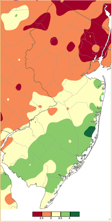
Figure 1. January 2026 precipitation across New Jersey based on a PRISM (Oregon State University) analysis generated using NWS Cooperative, CoCoRaHS, NJWxNet, and other professional weather station observations. Note the scale in inches at the bottom of the map. Totals range from 2.00”–2.49” (dark red) to 4.00”–4.49” (dark green).
January snowfall averaged 14.3” across NJ. This was 7.1” above normal and ranks as the 17th snowiest of the past 132 years. The northern snow division (Warren/Morris/Essex northward) averaged 19.9” (+10.3”, 14th snowiest), the central division (Hunterdon/Mercer/Somerset/Union/Middlesex/Monmouth) 16.6” (+8.9”, 13th snowiest), and the southern division (Burlington/Ocean southward) 10.2” (+4.5”, 24th snowiest). For the season to date, the statewide snowfall average is 21.7”. This is 9.7” above normal and ranks as the 17th snowiest season through January. It is the snowiest since 25.3” accumulated through the end of January in 2013/14.
Temperature
There were eight January days when one or more of the 70 Rutgers NJ Weather Network (NJWxNet) stations reached 50° or milder. All but one occurred between the 7th and 14th. On the other end of the thermometer, there were 16 days when the low temperature at one or more stations dropped to 10° or colder. All but three of those days occurred in the second half of the month.
Of the 50°+ days, the first was on the 7th with a high of 60° in Greenwich (Cumberland County), Hammonton (Atlantic), and Woodbine (Cape May). Thirty-two stations rose to 55°–59° and 18 from 50°–54° (Figure 2). High Point Monument (HPM; Sussex) had the lowest high at 37°. Lower Alloways Creek Township (LACT; Salem) reached 56° on the 8th, with 54 sites from 50°–55°. Woodbine made it to 59° and 53 stations from 50°–58° on the 9th. Cape May Court House (Cape May) and West Cape May (Cape May) hit 57° on the 10th, with 43 sites from 50°–56°. Egg Harbor Township (Atlantic) rose to 54° on the 11th, with nine stations from 50°–52°.
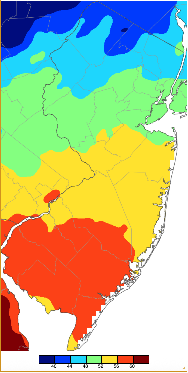
Figure 2. Maximum temperatures on January 7th based on a PRISM (Oregon State University) analysis generated using NWS, NJWxNet, and other professional weather stations. Note the 4° scale beneath the map.
With just a one-day break, the 13th again saw stations reach 50°, this time 53° at Fort Dix (Burlington), Hammonton, and Red Lion (Burlington), with 28 stations 50°–52°. The 14th rivaled the 7th as the mildest January day, with Hammonton at a January statewide maximum of 62°, four stations 60°–61°, and 43 from 50°–59° (Figure 3). Again, HPM was coolest at 41°. Eight days later, a quick warm up saw seven stations top out at 53° and 23 from 50°–52°.
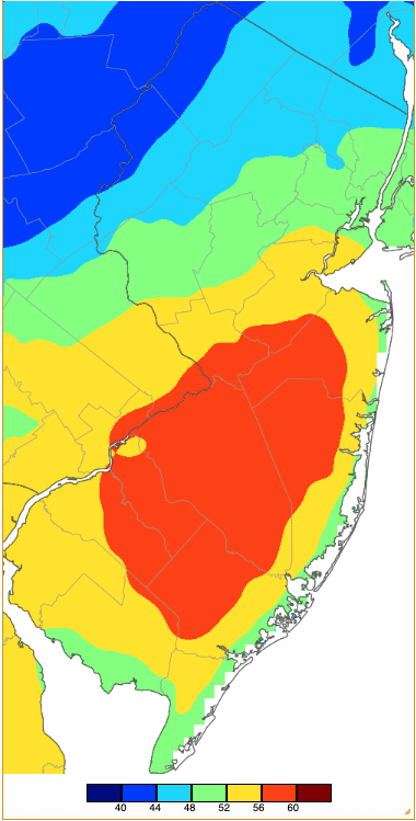
Figure 3. Maximum temperatures on January 14th based on a PRISM (Oregon State University) analysis generated using NWS, NJWxNet, and other professional weather stations.
Every January day had at least one NJWxNet station with a low of 32° or lower. Turning to the coldest of the cold, the first three days of the month saw lows of 9° or colder. High Point (Sussex) led the way at 7° on the 1st, with eight stations from 8°–10°. LACT and West Cape May were mildest at 26°. HPM dropped to 9° on the 2nd. Sandyston (Sussex) was 2° on the 3rd, along with Walpack (Sussex) at 4° and eight sites from 8°–10°.
Ten degree or colder minimums did not return until the 16th when HPM reached 9°. On the 19th, Hackettstown (Warren) was coldest at 7°, with three sites 8°–10°. The first subzero readings of the month occurred on the 20th, when Hopewell Township (Mercer) reached -6°, Kingwood (Hunterdon) -5°, five stations between 0° and -4°, and 40 sites from 1°–10°. Atlantic City Marina (Atlantic) and Little Egg Harbor Township (LEHT; Ocean) were mildest at 20°. From then on through month’s end, it was either Walpack (on calm, clear nights) or HPM (on windier nights, clear or cloudy) that took low honors. This commenced on the 21st, with -12° at Walpack, -10° in Hopewell Township, Kingwood, and Pequest (Warren), 0° to -9° at 13 locations, and 1°–10° at 39 stations. Atlantic City Marina was 31° milder than Walpack, coming in at 19° for a low. HPM was 0°, with 15 stations from 3°–10° on the 23rd. HPM fell to -4° on the 24th, three stations either 0° or -1°, and 59 from 1°–10°. A snapshot of not only how cold the air was but also how little moisture it contained is shown by the sub-zero dew point temperatures throughout the state on the morning of the 24th (Figure 4). These values are not necessarily the lowest of the month at any station but exhibit the magnitude of the low values and the overall consistency of the dew point observations, which ranged between -3° and -11°.
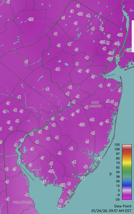
Figure 4. Dew point temperatures at 9:37AM on January 24th. Includes observations from the Rutgers NJ Weather Network, NJ DOT RWIS, National Weather Service, and Delaware Environmental Observing System.
HPM was -2° on the 25th, with 24 stations from 1°–10°. HPM made it down to 7° on the 26th with three other stations at 9° or 10°. Walpack led the way at -6° and Sandyston -4° on the 27th, when 32 other locations saw lows from 1°–10°. The coldest low of the month was the -17° reading at Walpack on the 28th. Sandyston dropped to -11°, three sites from 0° to -7°, and 37 from 1°–10°. Both LEHT and LACT were least cold at 16°. This spread of lows on the 28th (and on many other days) is not just a reflection of station altitude, distance from water bodies, or distance from urban locations, but, at times, may be a function of overnight wind or the lack thereof. For instance, in Figure 5, the Walpack minimum was attained with very low wind movement during the period when the temperature bottomed out, as cold air gently settled into the local valley. Meanwhile, Hillsborough-Duke in the broad Raritan Valley saw pre- and post-dawn temperatures fluctuate between 7° and 12° when the winds slackened, leading to colder conditions, or when picking up a bit, mixed some slightly milder air above the surface down to the six-foot height of the temperature sensor (Figure 6).
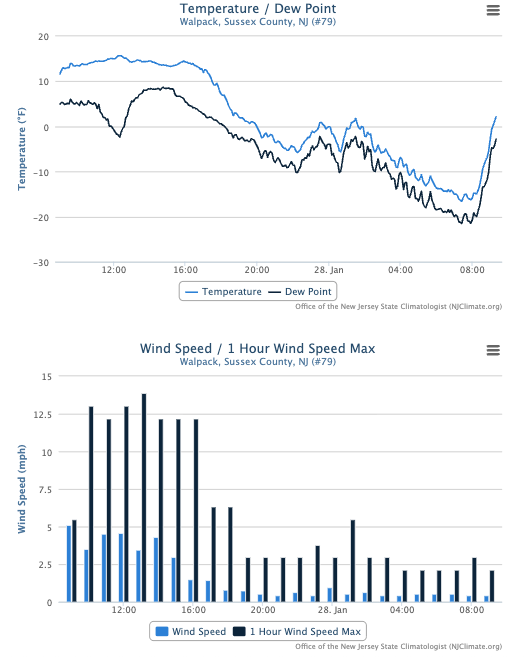
Figure 5. Time series of temperature and dew point (top) and average hourly wind speed and hourly wind speed maximum (bottom) at the Walpack NJWxNet station from 9 AM January 27th to 9 AM on January 28th.
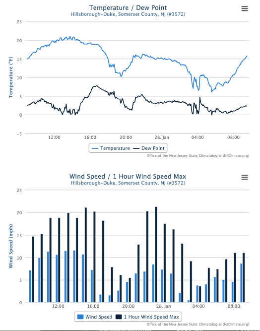
Figure 6. Time series of temperature and dew point (top) and average hourly wind speed and hourly wind speed maximum (bottom) at the Hillsborough-Duke NJWxNet station from 9 AM January 27th to 9 AM on January 28th.
Walpack dropped to -16° on the 29th, Pequest -10°, three stations from 0° to -9°, and 51 sites from 1°–10°. This time it was West Cape May mildest at 15°. On the 30th, Walpack reached -10°, eight stations from 0° to -5°, and 53 stations from 1°–10°. A thermal anomaly map covering a portion of the Northern Hemisphere centered over North America and the north Atlantic Ocean illustrates the location and depth of the coldest surface temperature anomalies over North America on the 30th. This includes locations from the northern U.S. Plains and southern Canadian Prairie southeastward over the Great Lakes to southern New England and the mid Atlantic. The well-above-normal temperatures to the north of this region reflect the southward drainage of Arctic air. The milder-than-normal air to the west results from the polar jet sitting to the north of its normal position in the western U.S., while the jet dips well to the south in the eastern U.S.
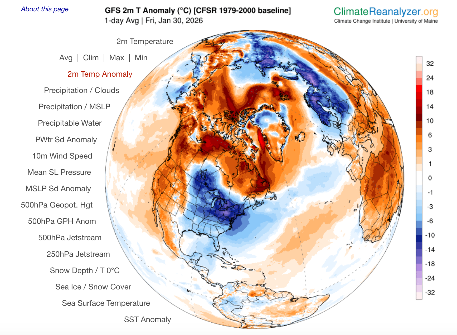
Figure 7. NOAA Global Forecast System average 2-meter temperature anomalies (in °C) for January 30th over a portion of the Northern Hemisphere centered over North America and the north Atlantic Ocean (Climate Reanalyzer, University of Maine).
While not supplying the statewide extreme low temperature for the month, the 31st found the most number of stations at their coldest for the month. Walpack dropped to -14°, Pequest -13°, 21 stations from 0° to -9°, and 45 from 1°–10°. The mildest that could be found was 11° in West Cape May (Figure 8).
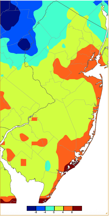
Figure 8. Minimum temperatures on January 31st based on a PRISM (Oregon State University) analysis generated using NWS, NJWxNet, and other professional weather stations.
Table 1 lists the coldest temperature during the month at a NJWxNet station in each county (except for Essex and Union, each without a NJWxNet station, where the Newark Airport station that is situated right at the border of the two counties is listed for both). Fourteen counties had a location register a subzero minimum. Sussex was coldest with Walpack’s -17° on the 28th and Hudson was least cold with Jersey City’s 9° on the 21st, 30th, and 31st. Most counties were coldest on the 31st (16), followed by the 21st (5), 28th (1), and 30th (1; the total county count comes to more than 21 due to duplicate days).
The 27th–31st brought five consecutive days with subzero lows at Walpack (8 for the entire month). This run was exceeded by six days in January 2025, with neither of these past two years approaching state records of 12 days at Newton (Sussex) in February 1979, 11 days at Layton (Sussex) in January 1961, and 10 days at both Sussex (Sussex) in January 1961 and in Culvers Lake from December 1917 into January 1918.
| County | Location | Minimum Temp. | Date |
|---|---|---|---|
| Atlantic | Mullica Township | -1° | 31st |
| Bergen | Haworth | -1° | 31st |
| Burlington | Woodland Township | -9° | 31st |
| Camden | Sicklerville | 1° | 31st |
| Cape May | Woodbine | -1° | 31st |
| Cumberland | Vineland | -3° | 31st |
| Essex | Newark Airport* | 5° | 31st |
| Gloucester | Piney Hollow | -2° | 31st |
| Hudson | Jersey City | 9° | 21st, 30th, 31st |
| Hunterdon | Kingwood | -10° | 21st |
| Mercer | Hopewell Township | -10° | 21st |
| Middlesex | New Brunswick | 3° | 21st |
| Monmouth | Howell | -3° | 31st |
| Morris | Chester Borough | 3° | 31st |
| Ocean | Berkeley Township | -7° | 31st |
| Passaic | Charlotteburg | -3° | 21st |
| Salem | Mannington Township | 2° | 31st |
| Somerset | Basking Ridge | -8° | 31st |
| Sussex | Walpack | -17° | 28th |
| Union | Newark Airport* | 5° | 31st |
| Warren | Pequest | -13° | 31st |
Table 1. The coldest January 2026 minimums at NJWxNet stations in each county.
*NWS Newark Airport station used for both Essex and Union.
Precipitation and Storms
An examination of several hundred Community Collaborative Rain, Hail, and Snow Network (CoCoRaHS) stations found the most January precipitation (rain and melted snow/sleet) fell at Berkeley Township (Ocean) with 4.27”, followed by Hammonton 4.26”, Lacey Township (Ocean) 4.20”, Somers Point (Atlantic) 4.13” and 4.09” (two sites), and Red Bank (Monmouth) 4.13”. Lowest monthly totals were observed in Harrison (Hudson) 2.26”, Cranford (Union) 2.28”, Montclair (Essex) 2.29”, Oakland (Bergen) 2.34”, and Little Falls Township (Passaic) 2.42”.
Turning to snow, the largest monthly CoCoRaHS station totals were attained at two Vernon Township (Sussex) sites with 27.9” and 26.8”. Next was Mine Hill Township (Morris) at 25.0”, Montague Township (Sussex) 24.9”, Liberty Township (Warren) 23.5”, Sparta Township 23.4”, and Newton (Sussex) 23.4”. The lowest totals included Lower Township (Cape May) 3.3”, Woodbine (Cape May) 3.7”, Estell Manor (Atlantic) 4.4”, Egg Harbor City (Atlantic) 4.6”, and Ocean City (Cape May) 5.6”.
The new year began with some early snow squalls on the 1st that brought measurable totals (at least 0.1”) to many locations, but only an inch or more to communities in four counties. This includes 1.1” in West Orange (Essex), Califon (Hunterdon) 1.7”, four locations in Morris County 2.0”, and Sparta Township (Sussex) 1.5”. Winds gusted to 55 mph at Moorestown (Burlington), 51 mph in Fortescue (Cumberland), and 40–49 mph at 12 NJWxNet stations.
Thereafter, dry conditions prevailed until the second half of the 9th when rain commenced and continued during the entire day on the 10th before ending in the pre-dawn hours of the 11th. Of 241 CoCoRaHS reports, stations in Middle Township (Cape May) and Lower Township led the way with 1.87”. They were followed by Lacey Township 1.83”, Hammonton 1.81”, and both Somers Point (Atlantic) and Maurice River Township (Cumberland) with 1.80”. Ninety-three stations caught 1.00”–1.79” and 60 from 0.50”–0.99”, with both Sparta Township and Hardyston Township (Sussex) receiving the least at 0.29” (Figure 9). The storm produced wind gusts of 53 mph at LACT and 40–48 mph at eight NJWxNet stations.
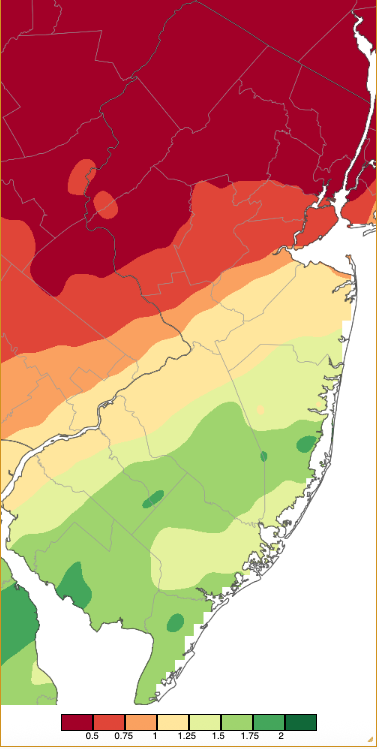
Figure 9. Precipitation across New Jersey from 7 AM on January 9th through 7 AM January 11th based on a PRISM (Oregon State University) analysis generated using NWS Cooperative, CoCoRaHS, NJWxNet, and other professional weather station observations. Totals range from 0.25”–0.50” (dark red) to 2.00”–2.25” (dark green).
Another week-long absence of meaningful precipitation followed before back-to-back modest systems brought a mixed bag of conditions to the state the weekend of the 17th–18th. Beginning as pre-dawn snow on the 17th, a change over to rain occurred in the south while snow continued at various intensities during the morning and afternoon in central and northern locales. Sixteen counties received measurable snow, 13 of them ≥1.0”, and of these seven ≥3.0” (Figure 10). Highland Lakes (Sussex) led the way with 5.4” (Table 2).
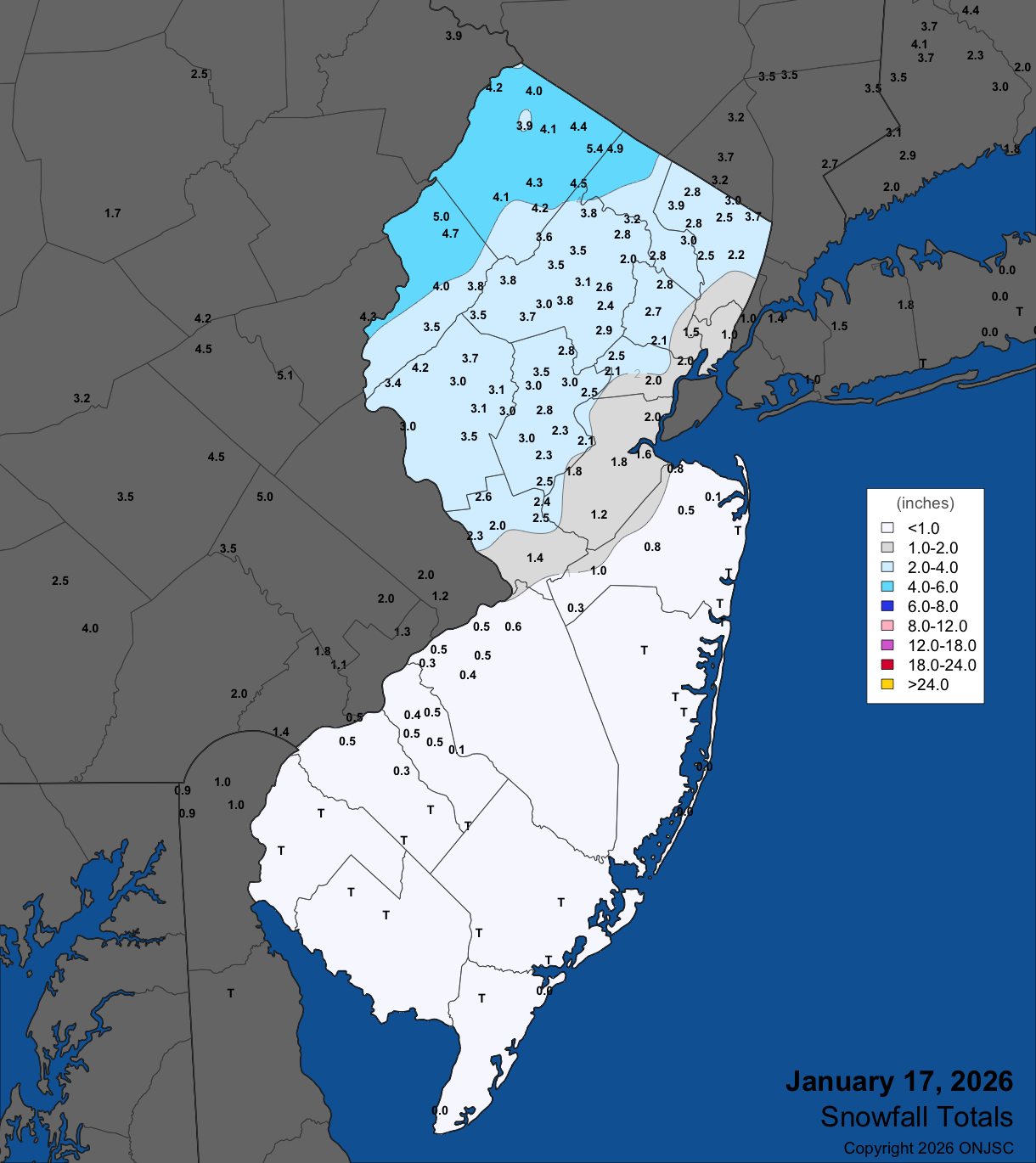
Figure 10. Snowfall on January 17th. Observations are from CoCoRaHS, NWS Cooperative Observer, and NWS Spotter reports.
| County | Location | Snowfall |
|---|---|---|
| Bergen | Northvale | 3.7” |
| Hunterdon | Bethlehem Township | 4.2” |
| Morris | Mount Olive Township & Mine Hill Township | 4.0” |
| Passaic | Upper Greenwood Lake | 4.9” |
| Somerset | Bedminster Township | 3.5” |
| Sussex | Highland Lakes | 5.4” |
| Warren | Hardwick Township | 5.0” |
Table 2. Maximum snowfalls for the January 17th storm in counties where at least one report exceeded 3.0”. Observations are from CoCoRaHS, NWS Cooperative Observer, and NWS Spotter reports.
Snow resumed during the pre-dawn hours of the 18th, with rain in the south. Continuing through the morning, precipitation slackened during the afternoon before picking up in intensity in the late afternoon into the evening as the snow line moved toward the coast. By event’s end, all 21 NJ counties had at least one location picking up ≥1.0” of snow, with 14 counties receiving ≥3.0” (Figure 11). Top honors went to Holland Township (Hunterdon) with 4.8” (Table 3).
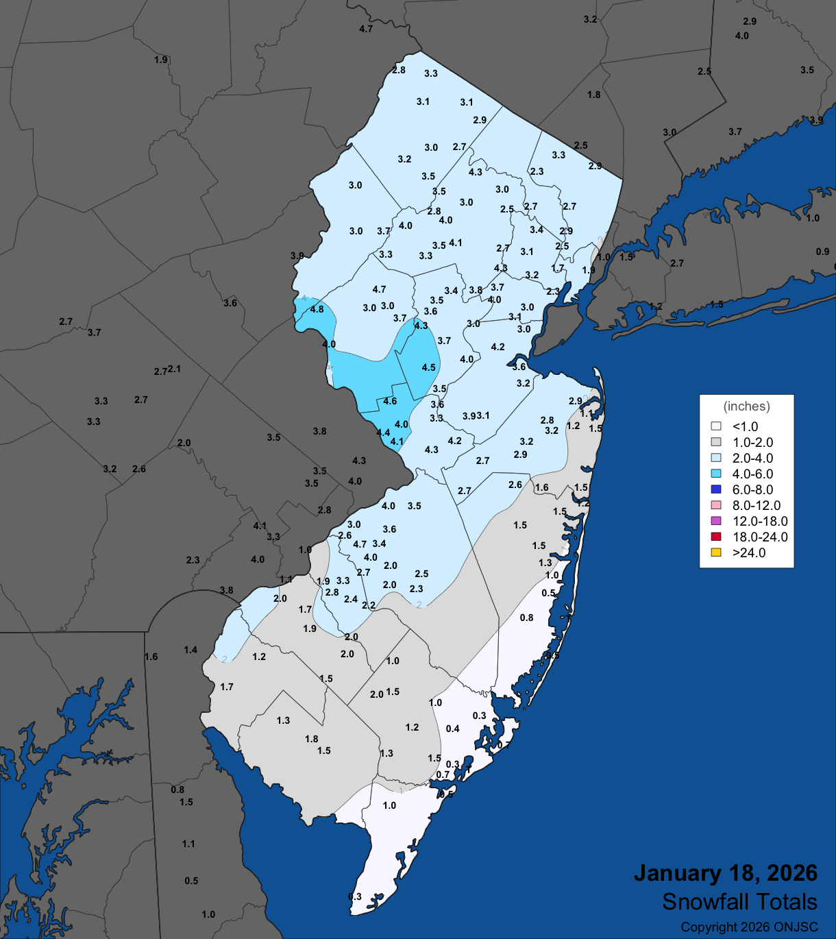
Figure 11. Snowfall on January 18th. Observations are from CoCoRaHS, NWS Cooperative Observer, and NWS Spotter reports.
| County | Location | Snowfall |
|---|---|---|
| Bergen | Ramsey | 3.3” |
| Burlington | Moorestown Township | 4.7” |
| Camden | Ashland | 3.3” |
| Essex | Cedar Grove | 3.4” |
| Hunterdon | Holland Township | 4.8” |
| Mercer | Woodsville | 4.6” |
| Middlesex | Edison | 4.2” |
| Monmouth | Freehold & Colts Neck Township | 3.2” |
| Morris | Chatham & Green Pond | 4.3” |
| Passaic | Little Falls Township | 3.2” |
| Somerset | Belle Mead | 4.5” |
| Sussex | Sparta Township | 3.5” |
| Union | Scotch Plains Township | 4.3” |
| Warren | Greenwich Township | 3.8” |
Table 3. Maximum snowfalls for the January 18th storm in counties where at least one report exceeded 3.0”. Observations are from CoCoRaHS, NWS Cooperative Observer, and NWS Spotter reports.
The most impactful storm of the season, at least thus far, began as pre-dawn snow moving up from the south on the 25th. A mixed bag of precipitation types emerged across the state as the event picked up in intensity. This was the result of above-freezing air invading between 6,000 to 8,000 feet above the surface, while in most of the state, surface temperatures remained well-below freezing. Flakes were even flying at temperatures as low as -1° at HPM. The milder air aloft resulted in a transition at ground level from snow to sleet that made it northward to central Jersey by midday. Just a bit of sleet eventually made it north of around the Interstate 80 corridor during what was almost an exclusively all-snow event in this area. In the south, the cold air near and at the surface was eroded away such that a transition to freezing rain occurred during the afternoon and, along the coast, temperatures rose above freezing with plain rain falling. During the storm, the National Weather Service’s Newark Airport and Philadelphia Airport stations each reported nine hours of sleet, with the latter site also seeing two hours of freezing rain.
Precipitation (rain, melted snow and sleet) totals were quite uniform throughout the state. Of 190 CoCoRaHS reports, Red Bank was on top with 2.39”, followed by Hammonton 2.15”, Point Pleasant Beach (Ocean) 2.05”, and Woodbridge Township (Middlesex) 2.03”. Some 119 stations reported from 1.50”–2.02” and 66 from 1.00”–1.49” (Figure 12).
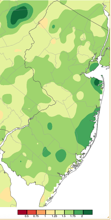
Figure 12. Precipitation across New Jersey from 7 AM on January 24th through 7 AM January 26th based on a PRISM (Oregon State University) analysis generated using NWS Cooperative, CoCoRaHS, NJWxNet, and other professional weather station observations. Totals range from 0.25”–0.50” (dark red) to 2.00”–2.25” (dark green).
Storm totals of snow and sleet ranged from a low of 3.0” at several Cape May County locations to 18.0” in Vernon Township (Figure 13). Every county had stations picking up at least 6.0”, with 14 counties having at least one location in double digits (Table 4). This included a top coating of as much as 2” of sleet, in spots glazed by freezing rain. Fortunately, freezing rain did not amount to enough to cause damage or power outages. Also, there was no coastal flooding, this due to the absence of persistent strong onshore winds. Not that winds on the 25th didn’t gust to 45 mph at Harvey Cedars (Ocean) and LEHT, and 42 mph at both Sea Girt (Monmouth) and Atlantic City Marina. Also, winds on the 26th gusted to 43 mph at LACT and Fortescue (Cumberland) and 40 mph at both Sea Girt and Pennsauken (Camden), but by then were blowing offshore from the northwest.
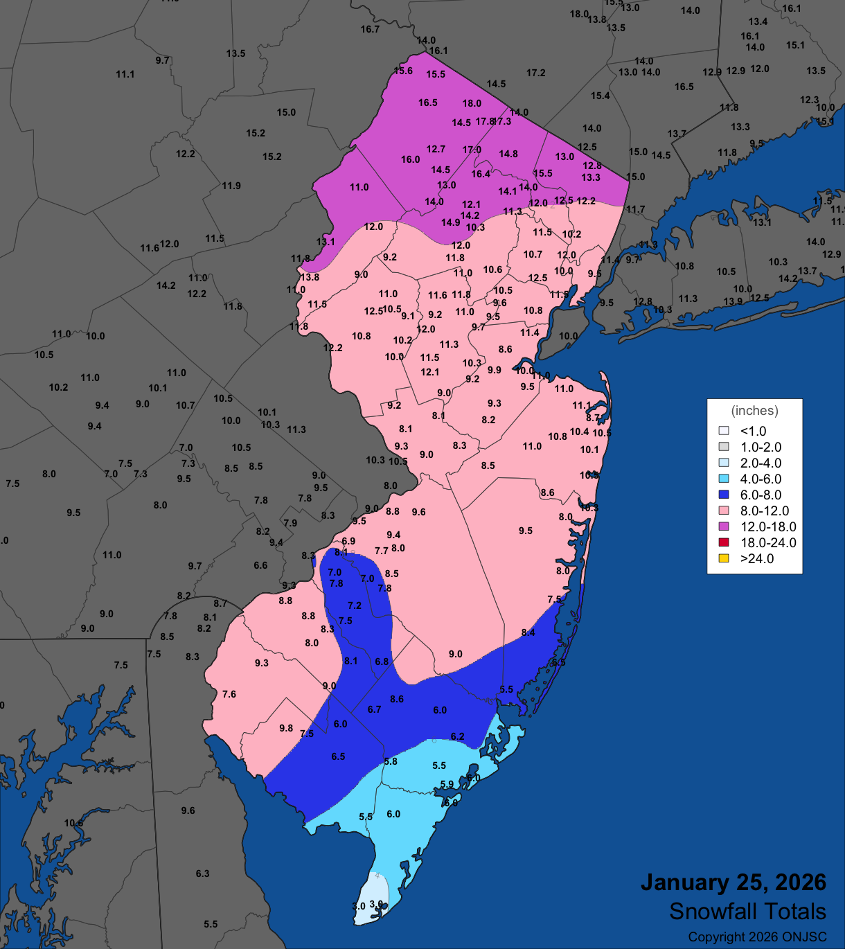
Figure 13. Snowfall (including sleet) on January 25th. Observations are from CoCoRaHS, NWS Cooperative Observer, and NWS Spotter reports.
| County | Location | Snowfall |
|---|---|---|
| Atlantic | Hammonton | 9.0” |
| Bergen | Oakland | 15.5” |
| Burlington | Columbus | 9.6” |
| Camden | Cherry Hill | 9.3” |
| Cape May | Ocean City & Woodbine | 6.0” |
| Cumberland | Upper Deerfield Township | 9.8” |
| Essex | Maplewood Township | 12.5” |
| Gloucester | Franklin Township & Greenwich Township | 9.0” |
| Hudson | Harrison | 10.0” |
| Hunterdon | Clinton Township | 12.5” |
| Mercer | Princeton | 10.0” |
| Middlesex | Woodbridge Township | 11.4” |
| Monmouth | Red Bank | 11.1” |
| Morris | Green Pond | 16.4” |
| Ocean | Point Pleasant Beach | 10.3” |
| Passaic | Upper Greenwood Lake | 17.3” |
| Salem | Woodstown | 9.3” |
| Somerset | Belle Mead | 12.1” |
| Sussex | Vernon Township | 18.0” |
| Union | Cranford Township | 11.8” |
| Warren | Harmony | 13.8” |
Table 4. Maximum snowfall for the January 25th storm in all 21 counties. Observations are from CoCoRaHS, NWS Cooperative Observer, and NWS Spotter reports.
The lowest barometric pressure of the month occurred on the 15th, ranging from 29.30”–29.40”. The highest pressure was on the 24th, at 30.60”–30.75”. Along with the four days with 40 mph gusts mentioned previously, five other January days reached that mark at one or more NJWxNet stations. This includes 41 mph at Fortescue on the 16th, LACT at 41 mph and Fortescue 40 mph on the 20th, LACT 47 mph, Pennsauken 46 mph and five sites from 40–44 mph on the 23rd, LEHT 44 mph, Harvey Cedars 43 mph and both Seaside Heights (Ocean) and LACT 40 mph on the 24th, and HPM 40 mph on the 30th.
Finally, it is important to look at where NJ sits drought wise as January ended. The state remains in a Drought Warning according to the NJ Department of Environmental Protection. The weekly US Drought Monitor map for the 27th had a portion of the northwest and the far south rated as D2 (severe drought), the remainder of the north and the southwest and lower south in D1 (moderate drought), much of the Pinelands over to the central and northern coast as D0 (abnormally dry), and just the Ocean County coast without drought or dry designations (Figure 14).
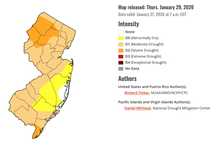
Figure 14. U.S. Drought Monitor map of conditions in NJ as of January 27, 2026.


