December Overview
The winter season of 2025/2026 took no time to display its wares this past month; it was quick out of the gate. Time will tell whether this was a sign of what lies ahead for the rest of the season. For now, enough cold, wind, and snow arrived this month to remind all that winter in NJ can be a force to be reckoned with.
Statewide, the average December temperature of 31.8° was 4.8° below the 1991–2020 normal and ranked as the 43rd coldest since records commenced in 1895. It was New Jersey’s coldest December since 2010 (ranked 29th) and third coldest since 2000 (ranked 18th). The average maximum of 40.5° was 4.5° below normal and ranked 49th coldest. The average minimum of 23.2° was 5.0° below normal and ranked 37th coldest. The northern climate division averaged 28.9° (-5.2°, 40th coldest), the southern division 33.5° (-4.6°, 46th coldest), and the coastal division 34.6° (-4.5°, 45th coldest).
Precipitation (rain and melted snow) amounted to a statewide average of 3.13”. This was 1.14” below normal and ranks as the 55th driest December. Totals were rather evenly distributed across the state (Figure 1). This was the 10th month of 2025 with below normal precipitation. The north averaged 2.86” (-1.39”, 42nd driest), south 3.31” (-0.97”, 58th driest), and coast 3.22” (-1.14”, 56th driest). On December 5th, the NJ Department of Environmental Protection (NJDEP) declared a transition from a statewide Drought Watch to a Drought Warning, indicative of the persistent precipitation deficits.
December snowfall averaged 7.4” across the state. This was 3.1” above average and ranked as the 33rd snowiest December on record and the snowiest since 8.6” in 2017. The northern snow region (Warren/Morris/Essex northward) averaged 11.8” (+5.5”, 24th snowiest), the central region (Hunterdon/Somerset/Union/Middlesex/Mercer/Monmouth) 8.5” (+3.7”, 32nd snowiest), and southern region (Burlington/Ocean southward) 4.4” (+1.4”, 39th snowiest).
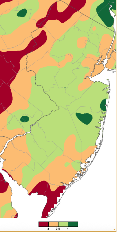
Figure 1. December 2025 precipitation across New Jersey based on a PRISM (Oregon State University) analysis generated using NWS Cooperative, CoCoRaHS, NJWxNet, and other professional weather station observations from approximately 7 AM on November 30th to 7 AM on December 31st. Note the scale in inches at the bottom of the map. Totals range from 2.50”–2.99” (dark red) to 4.00”–4.49” (dark green).
Wind played a role in December discomfort, with gusts of 40 mph or greater observed at one or more Rutgers NJ Weather Network (NJWxNet) stations on eleven days, with specifics to follow throughout the following “Precipitation and Storms” narrative.
The 70th station in the Rutgers NJ Weather Network was installed in early December and commissioned on the 13th. It is located on the grounds of the NJ American Water Company Weston-Canal Road Filtration Plant in Franklin Township (Somerset). Many thanks to NJ American Water for supporting this addition.
Precipitation and Storms
As mentioned previously, there was not a great disparity between the driest and wettest regions of NJ in December. The most precipitation was recorded by a Community Collaborative Rain, Hail, and Snow Network (CoCoRaHS) observer in Manchester Township (Ocean County) with 4.63”. This was followed by Neptune City (Monmouth) with 4.44”, Princeton (Mercer) 4.36”, Galloway Township (Atlantic) 4.20”, Wall Township (Monmouth) 4.19”, and Monroe Township (Gloucester) 4.15”. The least precipitation fell in the far south. Three observers in Middle Township (Cape May) reported 2.54”, 2.55”, and 2.78”, with three in Lower Township (Cape May) recording 2.54”, 2.62”, and 2.78”. Ocean City (Cape May) caught 2.75” and 2.91” at two locations, Liberty Township (Warren) 2.90”, and Ventnor City (Atlantic) 2.94”.
Monthly snowfall amounted to as much as 21.1” at one Vernon Township (Sussex) station, with 14.2” falling at a lower elevation in the township. Montague Township (Sussex) saw 17.2”, Sparta Township (Sussex) 14.9”, Mine Hill Township (Morris) 14.5”, Jefferson Township (Morris) 14.0”, and Frelinghuysen Township (Warren) 14.0”. December snowfall only amounted to about an inch in Cape May County.
As discussed in the November report, rain fell after the morning observing time on the 30th, thus counted in December totals. While totals were not heavy, top totals in the far south and along the coast included 0.42” in Middle Township and 0.37” at two Woodbine (Cape May) locations.
The first notable statewide event of the month moved from south to north beginning in the pre-dawn hours of the 2nd before ending late that afternoon (Figure 2). Most of NJ saw just rainfall, while northwest locations received the first measurable snow of the season. Precipitation (rain and melted snow) amounted to as much as 1.45” at Barnegat Light (Ocean), Galloway Township 1.34”, Stafford Township 1.33” and 1.30” (two stations), and Lacey Township (Ocean) 1.31”. Of 265 CoCoRaHS observations, 60 came in with 1.00”–1.45” and 201 from 0.50”–0.99”. Vernon Township received the least at 0.38”. Measurable snow fell in four counties, with top amounts in each amounting to 1.6” in Netcong (Morris), Upper Greenwood Lake (Passaic) 1.5”, Montague Township (Sussex) 4.7”, and Blairstown Township (Warren) 2.2” (Figure 3). As cold air moved in following the storm, a wind gust of 40 mph was observed at Pennsauken (Camden) on the 4th.
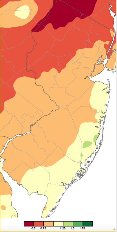
Figure 2. Precipitation across New Jersey from 7 AM on December 1st through 7 AM December 3rd based on a PRISM (Oregon State University) analysis generated using NWS Cooperative, CoCoRaHS, NJWxNet, and other professional weather station observations. Totals range from 0.25”–0.50” (dark red) to 1.75”–2.00” (dark green).
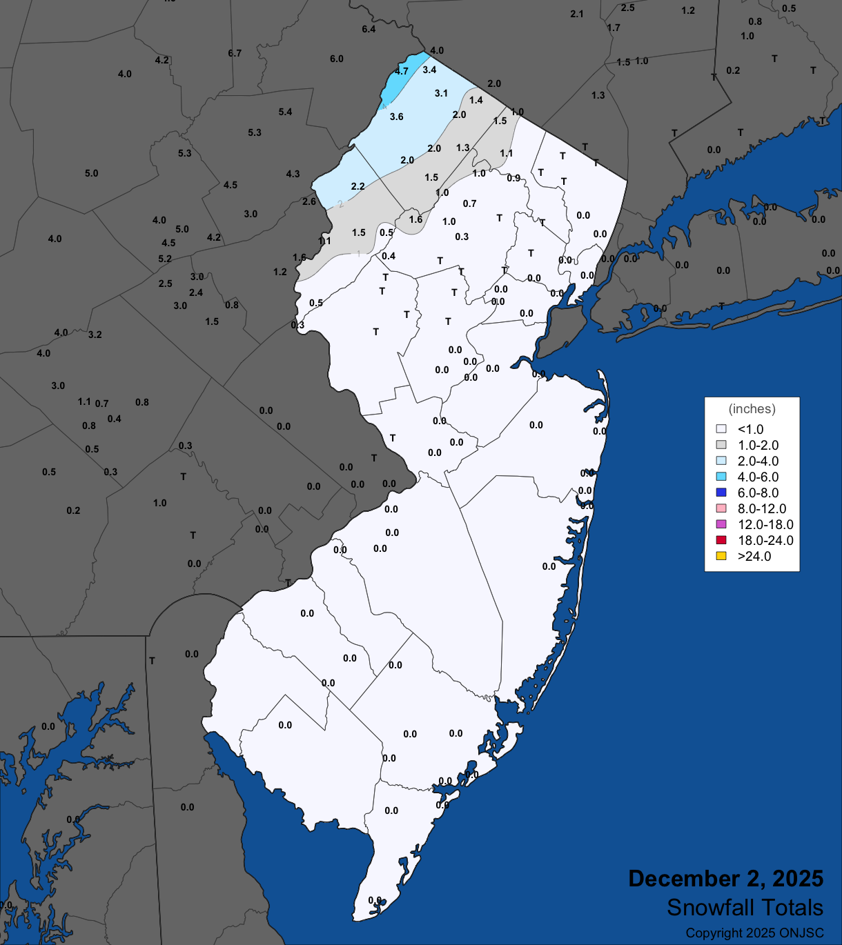
Figure 3. Snowfall on December 2nd. Observations are from CoCoRaHS, NWS Cooperative Observer Program, and NWS Spotter reports.
Light snow dusted central and northern areas early on the 6th, amounting to no more than 0.5”. A modest event during the afternoon and evening of the 10th delivered some light rain and snow. Precipitation amounted to no more than 0.30” in Lebanon (Hunterdon), Mount Olive Township (Morris), and Hackettstown (Warren). Measurable snow fell in four counties but only amounted to 0.1” at Califon (Hunterdon), Mount Olive Township 1.5”, Highland Lakes (Sussex) and Wantage Township (Sussex) each with 1.8”, and Frelinghuysen Township 2.2”. Peak gusts on the 10th included Atlantic City Marina (Atlantic) 43 mph and Little Egg Harbor Township (Ocean) 41 mph. The 11th found Little Egg Harbor Township gusting to 44 mph, Fortescue (Cumberland) 43 mph, and five NJWxNet locations from 40–42 mph. Some snow squalls blew into NJ on the 11th, the most notable one quickly laying down a light blanket in a narrow band across the north. This is seen in a mid-evening radar image that shows the path of the squall as it crossed the area (Figure 4). With clear skies on the morning of the 12th, the light snow cover from the squall can be seen in a visible satellite image (Figure 5).
Light snow dusted central and northern areas early on the 6th, amounting to no more than 0.5”. A modest event during the afternoon and evening of the 10th delivered some light rain and snow. Precipitation amounted to no more than 0.30” in Lebanon (Hunterdon), Mount Olive Township (Morris), and Hackettstown (Warren). Measurable snow fell in four counties but only amounted to 0.1” at Califon (Hunterdon), Mount Olive Township 1.5”, Highland Lakes (Sussex) and Wantage Township (Sussex) each with 1.8”, and Frelinghuysen Township 2.2”. Peak gusts on the 10th included Atlantic City Marina (Atlantic) 43 mph and Little Egg Harbor Township (Ocean) 41 mph. The 11th found Little Egg Harbor Township gusting to 44 mph, Fortescue (Cumberland) 43 mph, and five NJWxNet locations from 40–42 mph. Some snow squalls blew into NJ on the 11th, the most notable one quickly laying down a light blanket in a narrow band across the north. This is seen in a mid-evening radar image that shows the path of the squall as it crossed the area (Figure 4). With clear skies on the morning of the 12th, the light snow cover from the squall can be seen in a visible satellite image (Figure 5).
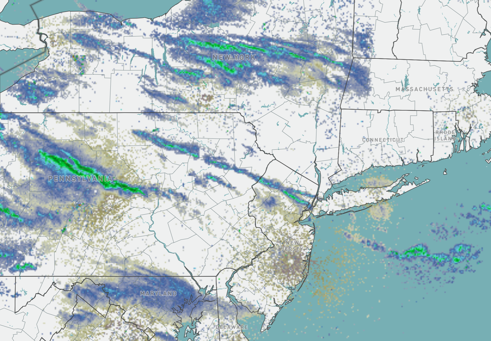
Figure 4. Mid-evening radar on December 11th showing a snow squall across a swath of north Jersey. Note additional squalls across Pennsylvania and New York and off the coast (NWS).
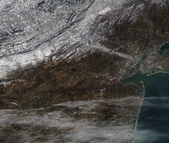
Figure 5. MODIS visible satellite image on the morning of December 12th. The previous evening’s squall path across north Jersey is seen compared to surrounding snow-free ground. Widespread snow cover is found to the northwest across northwest NJ, northeast PA, and part of NY. Cirrus clouds cover portions of South Jersey and southeast Pennsylvania (NASA).
The first snowstorm of the season impacted the entire state from the evening of the 13th into the morning of the 14th. Cold temperatures aloft and at the surface led to this being an all-snow event. Melted precipitation totals were not particularly large, at most amounting to 0.96” and 0.80” at two Pitman (Gloucester) stations, Glassboro (Gloucester) 0.83”, Manchester Township 0.80”, and 0.50”–0.96” at 113 of the 240 CoCoRaHS reporting locations. There was enough moisture to deliver measurable snow of 1.8” or more at locations in all 21 counties (Figure 6). Top totals for each county are found in Table 1, led by 8.5” in Howell (Monmouth), 8.2” in Highland Lakes, 7.8” in Manchester Township, and 7.7” in Hillsborough Township (Somerset).
As the storm departed, winds on the 14th gusted to 45 mph at Fortescue, 44 mph in Wantage, and 43 mph in West Cape May (Cape May). This was followed by a gust of 43 mph at High Point Monument (Sussex) on the 15th. A cloud-free morning of the 16th permitted a visible satellite image of the snow-covered state (Figure 7).
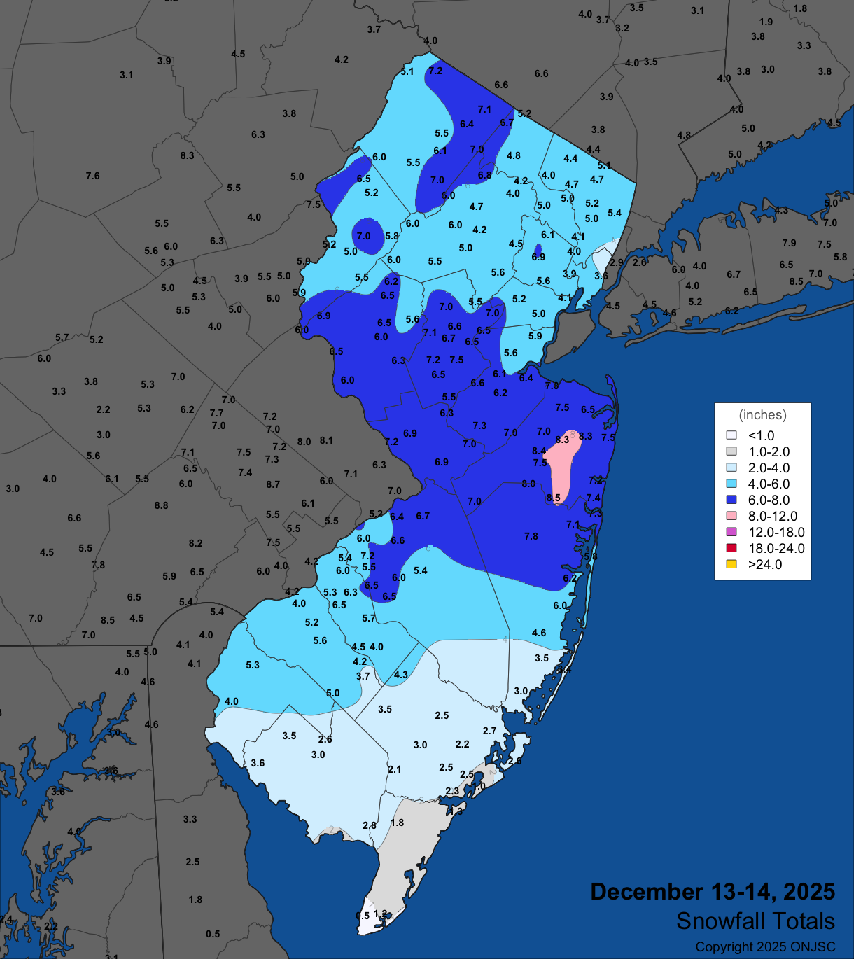
Figure 6. Snowfall on December 13th–14th. Observations are from CoCoRaHS, NWS Cooperative Observer Program, and NWS Spotter reports.
| County | Location | Snowfall |
|---|---|---|
| Atlantic | Hammonton | 4.5” |
| Bergen | Tenafly | 5.4” |
| Burlington | Moorestown Township | 7.2” |
| Camden | Somerdale | 6.5” |
| Cape May | Woodbine | 1.8” |
| Cumberland | Greenwich Township | 3.6” |
| Essex | West Orange Township | 6.9” |
| Gloucester | Pitman | 5.6” |
| Hudson | Jersey City | 5.0” |
| Hunterdon | Franklin Township | 7.4” |
| Mercer | Ewing Township | 7.2” |
| Middlesex | Cranbury | 7.3” |
| Monmouth | Howell Township | 8.5” |
| Morris | Green Pond | 6.8” |
| Ocean | Manchester Township | 7.8” |
| Passaic | Upper Greenwood Lake | 6.7” |
| Salem | Pilesgrove Township | 5.3” |
| Somerset | Hillsborough Township | 7.7” |
| Sussex | Highland Lakes | 8.2” |
| Union | Clark Township | 6.5” |
| Warren | Hardwick Township | 6.5” |
Table 1. Maximum snowfall for the December 13th–14th event in each county. Observations are from CoCoRaHS, NWS Cooperative Observer Program, and NWS Spotter reports.

Figure 7. MODIS visible image of snow-covered New Jersey and surrounding states on the morning of December 16th. Darker areas are heavily forested, thus much of the snow “hidden” by the overlying tree cover, especially in the southern Pinelands. The small dark “dot” in west central NJ is ice-free Round Valley Reservoir in Hunterdon County (NASA).
Temperatures quickly warmed from the 17th to 19th, leading to the next precipitation event falling as rain across the state. Rain fell from the evening of the 18th into the afternoon of the 19th. A swath from the southwest to northeast saw the highest totals, though a modest soaking occurred to the northwest and southeast (Figure 8). Deerfield Township (Cumberland) came out on top with 2.13”, followed by Monroe Township (Gloucester) 1.94”, Millville (Cumberland) 1.93”, Manchester Township 1.93”, Verona Township (Essex) 1.79”, and Wayne Township (Passaic) and Rockaway Township (Morris) each with 1.71”. Of 232 CoCoRaHS reporting stations, 186 received 1.00”–1.68” and forty-six from 0.50”–0.99”. Some localized street flooding was reported at multiple locations.
Statewide, strong winds accompanied the storm, with the 19th being one of the windiest days not only of 2025 but also dating back a decade or more. High Point Monument gusted to 63 mph, Logan Township 60 mph, Sea Girt (Monmouth) and Harvey Cedars (Ocean) each 54 mph, Wantage 53 mph, Lower Alloways Creek Township (Salem) and Pennsauken each 52 mph, Little Egg Harbor Township 50 mph, fourteen stations from 45–49 mph, and thirteen from 40–44 mph. Winds slowly declined but the 20th still brought gusts to 44 mph at High Point Monument, Wantage 43 mph, and Seaside Heights (Ocean) 42 mph. High Point Monument reached 42 mph on the 21st. Tree damage was reported throughout the state. One minor injury occurred when a tree fell on a car in Essex County and some roof damage was caused by wind and falling limbs. There were also numerous power outages, especially in the wooded areas in the northwest.
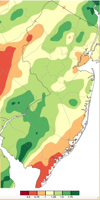
Figure 8. Precipitation across New Jersey from 7 AM on December 18th through 7 AM December 20th based on a PRISM (Oregon State University) analysis generated using NWS Cooperative, CoCoRaHS, NJWxNet, and other professional weather station observations. As in Figure 2, totals range from 0.25”–0.50” (dark red) to 1.75”–2.00” (dark green).
Pre-dawn snow moved into NJ on the 23rd before ending in some locations as mid-day light rain. Melted precipitation at best totaled 0.29” in Pompton Lakes (Passaic), 0.28” in Montague Township, and 0.26” at Oakland (Bergen). Measurable snow fell in fifteen counties, with nine of them picking up at least an inch (Figure 9). Four counties saw as much as 3.0” or more, including Bergen with Ramsey receiving 3.0”, Morris with Mount Arlington at 3.5”, Passaic where Upper Greenwood Lake came in at 3.1”, and Sussex where Highland Lakes received 4.0”. Following the event, winds on the 24th gusted to 53 mph at High Point Monument and 42 mph in Wantage.
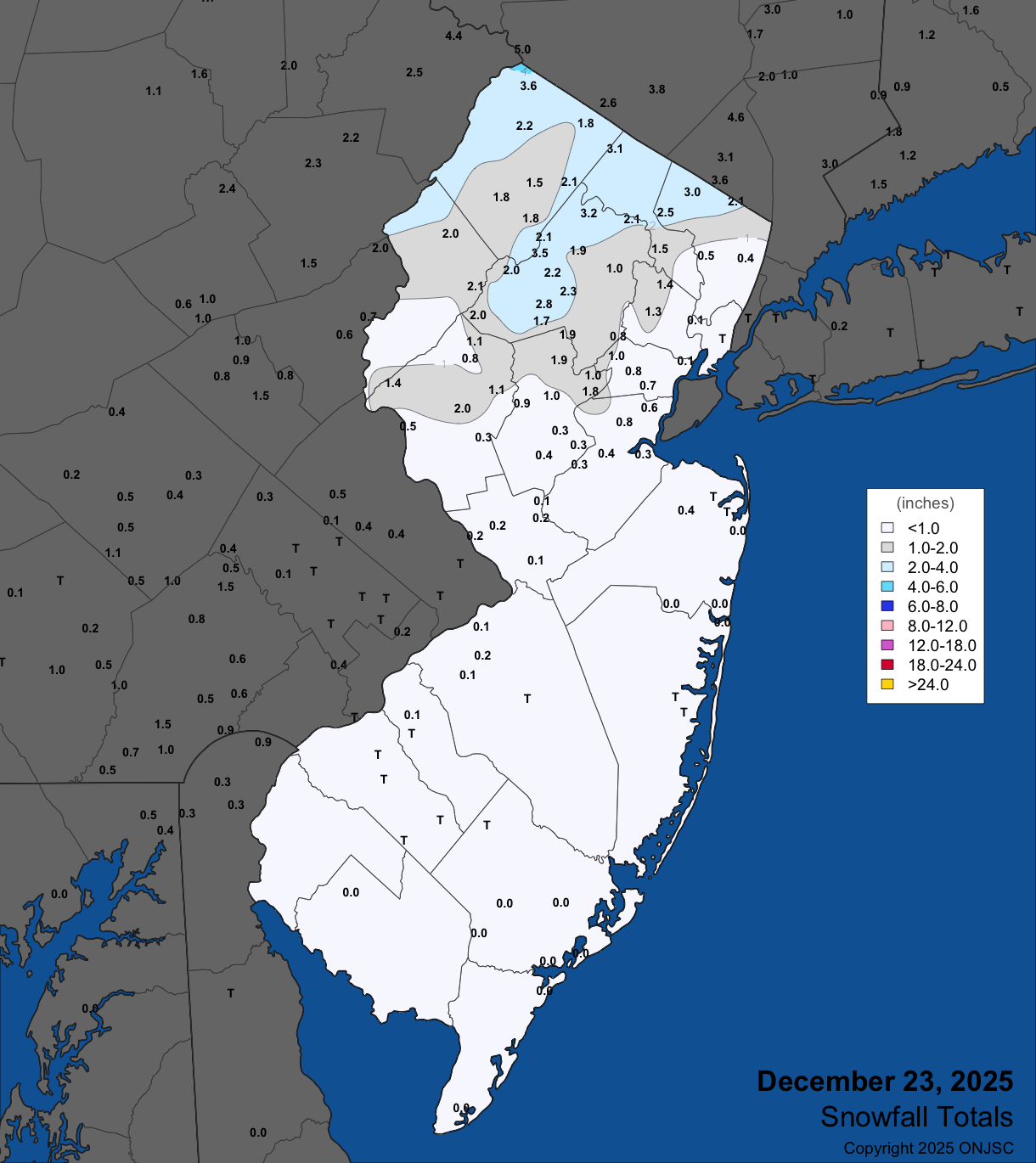
Figure 9. Snowfall on December 23rd. Observations are from CoCoRaHS, NWS Cooperative Observer Program, and NWS Spotter reports.
A mixed bag of precipitation fell from the afternoon of the 26th into early afternoon of the 27th. Rain and melted snow and sleet amounted to as 0.71” in both Wall Township and Neptune City, Hamilton Township (Mercer) 0.68”, Stafford Township (Ocean) 0.66”, and from 0.50”–0.65” at 91 CoCoRaHS stations. Seventeen counties received measurable snow or sleet, with many outside of the northeast seeing most precipitation in the form of sleet (Figure 10). Eight counties received 3.0” or more in frozen form, topped by 5.1” in Highland Lakes (Table 2).

Figure 10. Snowfall on December 26th–27th. Observations are from CoCoRaHS, NWS Cooperative Observer Program, and NWS Spotter reports.
| County | Location | Snowfall |
|---|---|---|
| Bergen | Northvale | 4.2” |
| Essex | West Orange Township | 4.0” |
| Hudson | Harrison | 4.0” |
| Morris | Rockaway | 4.5” |
| Passaic | Upper Greenwood Lake | 4.9” |
| Somerset | Bedminster Township & Watchung | 3.0” |
| Sussex | Highland Lakes | 5.1” |
| Union | Newark Airport | 4.2” |
Table 2. Maximum snow/sleet totals for the December 26th-27th event in counties receiving 3.0” or more. Observations are from CoCoRaHS, NWS Cooperative Observer Program, and NWS Spotter reports.
Light rain fell from late afternoon on the 28th into the morning of the 29th. Minor totals were led by 0.27” in Hackettstown and 0.26” at Woodbridge Township (Middlesex). Strong winds followed a frontal passage from the afternoon of the 29th into the early hours of 31st. Peak gusts on the 29th included 58 mph at Little Egg Harbor Township, Fortescue 55 mph, Lower Alloways Creek Township and Harvey Cedars each at 54 mph, Pennsauken 52 mph, ten stations from 45–49 mph, and thirteen from 40–44 mph. The 30th brought peak gusts of 51 mph at High Point Monument, six stations from 45–49 mph, and eleven from 40–44 mph.
As a cold front crossed the state on the 29th, temperatures were slow to begin falling, in part because the sun emerged for several hours. Winds ramped up over these hours, while, within an hour or two post frontal passage, dewpoints plummeted 20° or more as dry air surged in. The temperature/dew point and average wind speed and gust graphs show conditions at the new Franklin Township (Somerset) NJWxNet station (Figure 11).
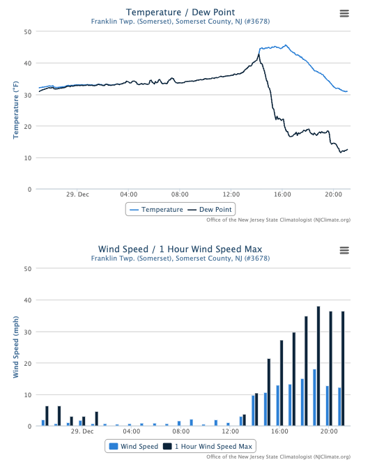
Figure 11. Time series of temperature and dew point (top) and average hourly wind speed and hourly wind speed maximum (bottom) at the Franklin Township (Somerset) NJWxNet station from 10 PM on December 28th to 10 PM on December 29th.
December barometric pressures topped out at 30.45”–30.60” on the 22nd. Lowest pressures were 29.25”–29.40” on the 19th and 29.25”–29.35” on the 29th, providing some explanation for the excessive winds on both days.
As mentioned earlier, drought remained in the picture across the state as the year ended (Figure 12). Along with the NJDEP Drought Warning, the US Drought Monitor showed worrisome conditions in most of the state. The December 30th map found 88% of the state ranging from Abnormally Dry (33%) to Moderate Drought (47%) to Severe Drought (8%).
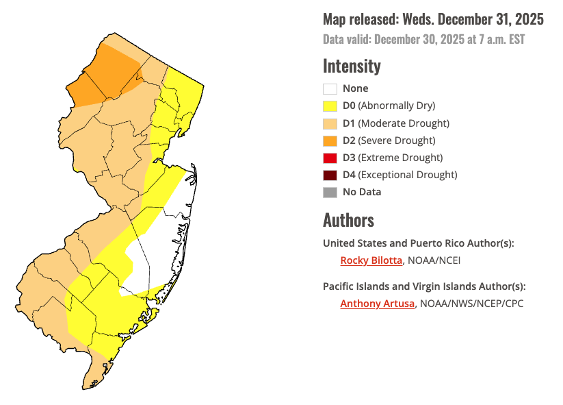
Figure 12. U.S. Drought Monitor map of conditions in NJ as of December 30, 2025.
Temperature
Over the course of this well below normal month, minimum temperatures fell to 10° or lower at one or more NJWxNet stations on twelve days. The 4th was the first such day, with High Point Monument at 10°. The 5th found Walpack (Sussex) down to 2°, Sandyston (Sussex) and High Point Monument each 4°, High Point (Sussex) 5°, and four stations from 6°–10°. Walpack was 7° on the 8th with two stations from 8°–10°. The 9th was the coldest day of the month with Walpack at -2°, Sandyston 0°, four sites from 1°–5°, and fifteen from 6°–10° (Figure 13). Lower Alloways Creek Township and Atlantic City Marina were “mildest” at 20°.
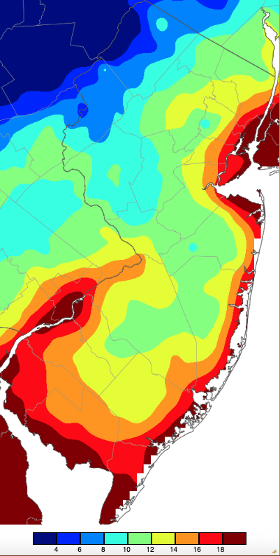
Figure 13. Minimum temperatures on December 9th based on a PRISM (Oregon State University) analysis generated using NWS, NJWxNet, and other professional weather stations. Note the 2° scale beneath the map.
Walpack was at 8° and Sandyston 9° on the 12th. Walpack fell to 5°, Sandyston 6°, and Pequest (Warren) and Hopewell Township (Mercer) both 10° on the 13th. High Point Monument reached 9° on the 14th. Walpack fell to 7°, Kingwood (Hunterdon) and High Point Monument each 9°, and Hackettstown 10° on the 15th. Hopewell Township and Kingwood, both at 7°, took low honors on the 16th, with Pequest at 9° and four stations at 10°. Hillsborough-Duke (Somerset) reached 8°, Pequest and Hopewell Township each 9°, and Hackettstown and Kingwood both 10° on the 17th.
Over a week later, High Point Monument bottomed out at 7° on the 26th, with Vernon Township and High Point each at 10°. Basking Ridge (Somerset) reached 7° and Hillsborough-Duke 10° on the 28th.
Eleven December days when lows were 15° or colder at one or more stations saw the mildest station in the state between 20° and 25° milder. The largest difference was on the 17th when Hillsborough-Duke fell to 8° while Atlantic City Marina, West Cape May (Cape May), and Fortescue only made it down to 33°.
Despite the cold month, daily maximum temperatures rose to 50° or milder on eight days. The first such day was the 2nd with Atlantic City Marina up to 55° and sixteen stations from 50°–54°, as High Point Monument only made it to 30°. It took over two weeks to reach 50° again anywhere in NJ when Cape May Court House reached 54° with fifteen stations 50°–53° on the 17th. Dennis Township (Cape May) and Vineland (Cumberland) rose to 58° with fifty stations from 50°–54° on the 18th. Ten stations rose to 60° on the 19th, the warmest December day (Figure 14). This included fifty-one stations at 55°–59° and eight sites from 52°–54°, the coolest reading of 52° at both High Point Monument, the northernmost NJWxNet station, and West Cape May, the southernmost station.
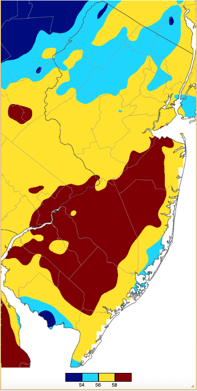
Figure 14. Maximum temperatures on December 19th based on a PRISM (Oregon State University) analysis generated using NWS, NJWxNet, and other professional weather stations.
Four stations rose to 52° on the 21st, with eleven at 50° or 51°. Woodbine reached 52° on the 24th, with twenty at 50° or 51°. The 25th found six stations at 52° and thirty-seven either 50° or 51°. High Point Monument was coolest at 38°. The second mildest day of December occurred on the 29th with Cape May Court House (Cape May) at 60°, twenty-seven stations from 55°–59°, and thirteen from 50°–54°.
In addition to the 25° difference between high temperatures on the 2nd, there was a 21° difference on the 13th (four stations at 48°, High Point Monument 27°), and a 21° difference on the 29th (Cape May Court House 60°, High Point Monument 39°).
High Point Monument was one of multiple stations that fell to freezing each day of December and led the way with twenty-one days with subfreezing high temperatures. Atlantic City Marina fell to freezing on just nineteen days and only had one day with a sub-freezing high.
Annual Overview
For our annual ranking of the top 10 weather/climate occurrences of 2025, visit here. Below, temperature and precipitation conditions across NJ are recapped for the past year.
Statewide annual precipitation averaged 38.88”, which is 8.68” below the 1991–2020 normal and ranks as the 17th driest since 1895 (Figure 15). This was the driest year since 2001 and second driest since 1981. Ten months had below normal precipitation. Of the two above average months, May ranked 7th wettest. The northern climate division averaged 38.01” (-10.71”, 8th driest of 131 years), the southern division 39.31” (-7.57”, 29th driest), and the coastal division 40.29” (-6.29”, 34th driest).
Annual precipitation at individual CoCoRaHS stations reached a maximum of 51.00” in New Providence (Union), followed by Stafford Township (Ocean) 50.85”, Warren Township (Somerset) 48.92”, Mount Laurel Township (Burlington) 48.90”, Galloway Township (Atlantic) 47.60”, and Point Pleasant Beach (Ocean) 47.13”. The driest location was Sparta Township (Sussex) with 34.59, followed by Monroe Township (Gloucester) 35.61”, Blairstown Township (Warren) 35.65”, Mantua Township (Gloucester) 36.99”, Lower Township (Cape May) 37.22”, and Ewing Township (Mercer) 37.58”.
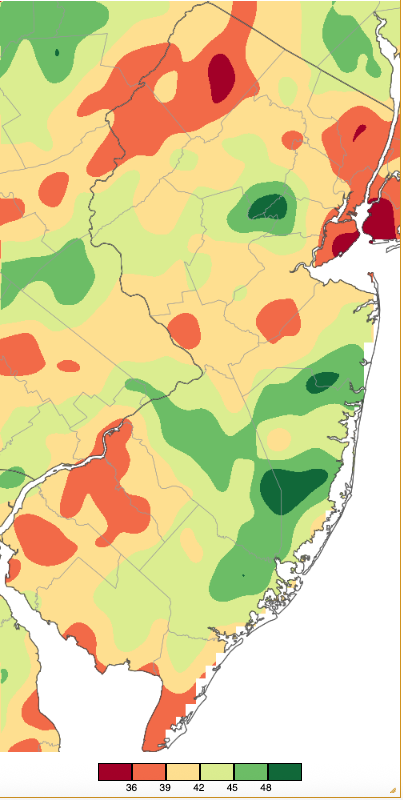
Figure 15. Annual 2025 precipitation across New Jersey based on a PRISM (Oregon State University) analysis generated using NWS Cooperative, CoCoRaHS, and NJWxNet weather station observations. NJ totals ranged from 33.00”–35.99” (red) to 48.00”–50.99” (dark green).
The wet May and above average July led to the statewide Drought Warning from the NJ Department of Environmental Protection that had been in place since November 13, 2024, being reduced to a Drought Watch only in the Coastal South Drought Region on June 11th. However, a return of dry conditions led to the NJDEP expanding the Drought Watch to the entire state on October 1st. This transitioned to a Drought Warning on December 5th.
The statewide average 2025 temperature of 53.7° was 0.1° above the 1991–2020 normal and ranks as the 21st warmest year since 1895. Seven months had above normal temperatures, with three ranking in the top 10 for warmth: March (10th), June (9th), and July (5th). None of the five below normal months were close to the top 10 coolest. The three coolest in terms of rankings were January (43rd), August (37th), and December (43rd). Spring was the 5th mildest and the March–July interval was the 4th warmest. The average annual temperature of 53.7° was 0.1° above average, ranking as the 21st warmest on record. The average maximum of 63.6° was 0.1° above average, ranking 23rd warmest. The average minimum of 43.9° was 0.3° above average, ranking 16th warmest. The northern climate division averaged 51.9° (+0.4°, 19th warmest), the southern division 54.8° (no departure, 23rd warmest), and coastal division 55.2° (+0.3°, 20th warmest).
The highest daily maximum temperatures of the year at stations throughout NJ and adjacent areas were used to generate Figure 16. This map and the others that follow do not depict temperatures occurring on a single day for all locations, rather they display the extreme temperatures achieved on any day during the year for a given location, based on dozens of stations. Figure 16 shows that the entire state made it to 93° or higher at least once during the year. The highest temperature in NJ in 2025 was 103° at Hammonton (Atlantic), Toms River (Ocean), Woodland Township (Burlington), and Newark Airport (Union) on June 24th.
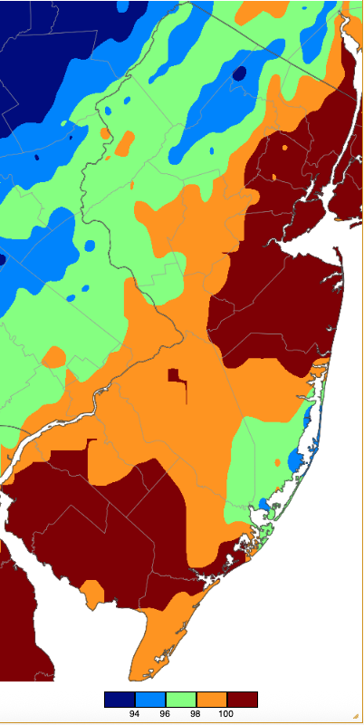
Figure 16. Annual maximum temperatures across NJ during 2025 based on a PRISM (Oregon State University) analysis generated using NWS, NJWxNet, and other professional weather stations. The annual maximum occurred on different days at different locations.
The lowest daily maximum (high) temperatures of the year are mapped in Figure 17. Areas in the northwest saw minimum highs in the mid-teens, with the remainder of the state mainly having their coldest daily maximum in the upper teens to low 20°s.
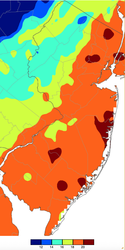
Figure 17. Annual minimum maximum temperatures across NJ during 2025 based on a PRISM (Oregon State University) analysis generated using NWS, NJWxNet, and other professional weather stations. The annual minimum high temperature occurred on different days at different locations.
The coldest temperatures of the year are depicted in Figure 18. The northwest experienced lows below zero, coastal and urban areas bottomed out between 4° and 12°, and the interior northeast, central, and interior southern areas were between -4° and 4°. The coldest temperature in NJ in 2025 was -17° at Walpack on January 22nd.
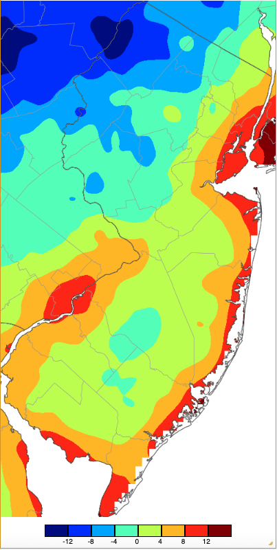
Figure 18. Annual minimum temperatures across NJ during 2025 based on a PRISM (Oregon State University) analysis generated using NWS, NJWxNet, and other professional weather stations. The annual minimum temperature occurred on different days at different locations.
The maximum minimum (low) temperatures mapped in Figure 19 are between 74° and 78° over most of the state. Elsewhere, they ranged from 70°–74° in the northwest and mostly from 78°–82° in the urban northeast and along the Delaware River and Delaware Bay coasts.
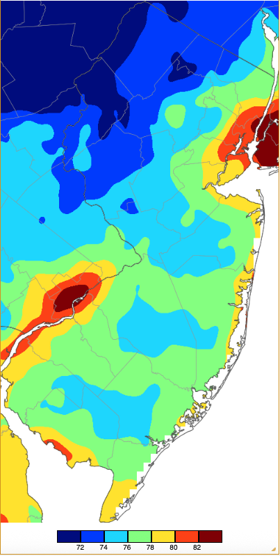
Figure 19. Annual maximum minimum temperatures across NJ during 2025 based on a PRISM (Oregon State University) analysis generated using NWS, NJWxNet, and other professional weather stations. The annual minimum low temperature occurred on different days at different locations.


