
Off Goes the Faucet: September 2019 Recap
 at the end of September. Photo by Dave Robinson.")
No months prior to this past September have been drier across New Jersey since February 2009, a testament to how precipitation has leaned toward the wet side since the last major drought impacted the state in 2002. The 1.21” received this September was 2.84” below the 1981–2010 average. This ranked as the 7th driest September since records commenced in 1895. February 2009 saw only 0.66”, but since February is on average the driest month of the year (2.80”), the last time a monthly deficit was larger than this September was the 3.06” departure in September 2007. Since 2000, only six other months early in the century have been drier (February 2002: 0.75”, October 2000: 0.77”, March 2006: 0.82”, October 2001: 0.93”, November 2001: 1.00”, and September 2005: 1.19”).
Conditions were driest in the north, averaging 1.06”, which is 3.41” below normal and ranks as the 4th driest September on record. Southern NJ ranked 12th driest with 1.30”, which is 2.52” below normal. This “flash drought” depleted soil moisture, resulting in brown lawns and shallow-rooted trees losing leaves early. Fire danger also increased, resulting in a ban on open fires. At month’s end, the US Drought Monitor had most of NJ in the D0 (abnormally dry) category, with Salem County experiencing moderate drought (D1) conditions. Thanks to above-average precipitation earlier this year, northern NJ reservoir levels remained above early-fall averages. Certainly, a watchful eye will be kept on all water resources should this dry spell continue.
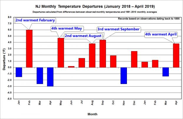
Above-average temperatures helped to dry things out in September. The 69.1° statewide average was 3.3° above the 1981–2010 mean. This ranks as the 8th warmest September over the past 125 years (tied with 1921; Table 2). Southern areas were warmest, at 3.5° above normal, while the north was 2.8° above.
 on August 7th. Photo by the Perth Amboy Police Dept.")

 following strong winds from a storm on July 22. Photo from the Holmdel Township Police Department.")
 on June 20th. Photo by Elizabeth Robertson/The Philadelphia Inquirer.")
 on May 29th following an EF1 tornado on the previous evening. Photo by Michael Mancuso/NJ Advance Media.")
 scenes on April 29, 2018 (top), and 2019 (bottom), demonstrating that spring 2019 experienced a green up that was noticeably earlier than 2018. Photos by Doug Robinson.")
 on the morning of March 4th. Photo by Dave Dabour.")
, which fortunately landed between two buildings. Photo by <a href=\"https://twitter.com/buo01/status/1100148820812464129\" target=\"_blank\">Twitter user @buo01</a>.")