News

Frequently Wet: May and Spring 2019 Recaps

June 5, 2019 - 11:08pm -- Dave Robinson

Stanhope tornado damage

As was seen earlier this spring, rainfall was quite persistent during a good portion of May. However, unlike April, it was not just a matter of frequency but ultimately, quantity that made for soggy conditions in the fifth month of 2019. The statewide average precipitation was 6.70”, which is 2.71” above the 1981–2010 mean. This made for the 9th wettest May since records commenced in 1895. The northern half of NJ was wettest, averaging 8.69” (+4.35”), making it the 3rd wettest on record. Only May 1989 (10.13”) and 1984 (9.79”) saw more rain. The south averaged 5.52” (+1.72”), ranking 17th wettest.

Based on observations from 62 NJWxNet stations, there were only two calendar days (22nd and 25th) without measurable (0.01”) rainfall at any location. Three days saw a maximum of 0.01”–0.10” at one or more stations, nine with a maximum between 0.11”–0.25”, and eleven topping out from 0.26”–0.99”, while on six days one or more station received an inch or greater.

The wet conditions were accompanied by above average temperatures. The 62.7° statewide average was 2.1° above the 1981–2010 mean. This ranked as the 19th mildest May on record (tied with 1985). However, it is only the 8th warmest May since 2004. Ten of the past 12 months have been above average.

NJ Warming Knows All Seasons

May 24, 2019 - 2:28pm -- Dave Robinson

Monthly Temperature Departures, Jan 2018-Apr 2019

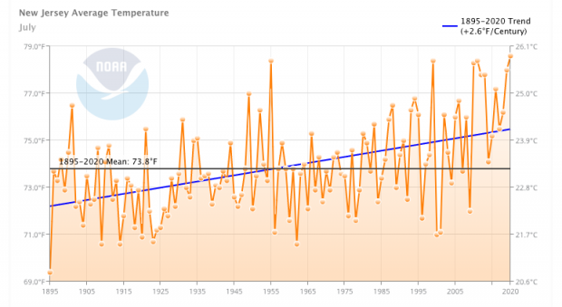
So often over the past roughly year and a half, I have been writing about statewide monthly temperatures being among the warmest on record. In fact, February, May, August, and September 2018, as well as April 2019, have ranked as 2nd, 4th, 2nd, 3rd, and 4th warmest, respectively, since statewide averages began being generated in 1895. Throughout this century, this has so often been the case that, seemingly, it is almost expected each month. Not necessarily a top 5 ranking, but often in the top 20.

This got me wondering whether I was exaggerating the warmth since 2000. Thus an evaluation of rankings was performed for each month and for the year as a whole. This included generating counts of the warmest top 10 and top 20 warmest months since 1895 that have occurred from January 2000 through April 2019.

A Real Spring: April 2019 Summary

May 6, 2019 - 2:34pm -- Dave Robinson

In recent years, complaints have been voiced that New Jersey “never” has a real spring anymore. Now just what is meant by that comes into question, as some think spring should most often have sunny 70° days with a few April showers included now and again! However, the main point has been that in recent years NJ has seemingly gone right from winter to summer. Whether it was a cold March and record mild April in 2017 or a snowy March and chilly April 2018 followed by the 4th warmest May, the transition has been rapid. This year, despite April being quite mild, conditions did include a mix of chilly and warm spells, sunny and dreary days, and even some nasty spring thunderstorms and gusty winds. Vegetation greened up a week or so ahead of schedule, and with it there was far more pollen dispersed than many appreciated. However, the green up was not so early that there was a great threat from a late-season freeze. Though on the 29th, the blueberry crop closely escaped damage from a light frost and freeze during a vulnerable growth period.

Statewide, it was the 4th mildest April since records commenced in 1895. The 54.7° average was 3.8° above the 1981–2010 mean and ranked 4th mildest. Six of the top ten and nine of the top 20 mildest Aprils have occurred since 2002. The average daily minimum temperature ranked 3rd highest and average maximum 10th.

Precipitation was about as average as can be. The statewide average of 3.95” was 0.04” below the 1981–2010 average and 0.22” wetter than the 1895–present average. It was the 43rd wettest April of the past 125 years, once again demonstrating how monthly precipitation totals tend to be skewed below the mean.

Lambs and Lions: March 2019 Summary

April 5, 2019 - 5:07pm -- Dave Robinson

Snow photo

Much like last month, March 2019 had a wide variety of weather conditions across the Garden State. The month came in like a lion, with a week of wintry weather, which was particularly snowy in northern and central regions. More snow fell than in any other month this season and the temperature fell below zero in one location and down to single digits at a number of others. The remainder of the month was often lamb-like, including four days with high temperatures exceeding 70° at many locations and six in the 60°s. Several inch-plus rain events occurred, along with the first lightning-filled squall line of the year, which, in some locations, included hail and strong winds.

The statewide monthly temperature averaged 39.7°. This is 1.1° below the 1981–2010 average and is the 58th mildest (66th coolest) since 1895. The statewide average rain and melted snow totaled 3.91”. This is 0.20” below the 1981–2010 average. It was the 61st wettest (65th driest) March since 1895.

Statewide snowfall averaged 6.3”. This was 1.9” above average. Northern counties averaged 13.0” (6.7” above average), the central region 8.6” (+3.5”), and south 1.6” (-1.5”). As a preview of the seasonal snow summary in next month’s report, statewide snowfall through March is 20.5”, 5.0” below average. Barring the unlikely case of April snowfall exceeding any other month of the season, this will mark the first time since records began in 1895 that March was NJ’s snowiest month of the season for three consecutive snow seasons (October–April).

A Little Bit of This and a Little Bit of That: February and Winter 2019 Recaps

March 5, 2019 - 8:23pm -- Dave Robinson

Tree felled by wind

The second month of 2019 across New Jersey was not one that will leave an indelible mark in the memory bank. Unlike some of the wild conditions that afflicted many other parts of the nation, NJ precipitation events were only minor to moderate, and there was nothing in the way of stream and river flooding. On several occasions, cold and warmth came and went rather quickly. There were no coastal storms, thus no significant tidal flooding or beach erosion. While there was one notable wind event, overall, rather calm conditions prevailed.

The statewide average precipitation (rain and melted snow) was 3.27”. This is 0.47” above the 1981–2010 average and ranks as the 47th wettest February since 1895. The statewide average temperature of 34.8° was 1.3° above average, and ranks as the 26th mildest February of the past 125 years.

Ambivalence: January 2019 Summary

February 7, 2019 - 5:19pm -- Dave Robinson

Marcal paper plan fire aftermath

If there was one thing the weather of January did not possess, it was a consistent identity. Though one might say that conditions during the first month of 2019 were consistently inconsistent, oftentimes with rapid transitions. Yet when all was said and done, conditions did not average too much from the long term norm. Statewide, the average temperature of 31.9° was just 1.2° above the 1981–2010 mean and ranks as the 35th mildest since 1895. This included two days where the thermometer topped 60° in a few locations and four days with some places falling below zero. Rain and melted snow totaled 4.39” on average, which was 0.99” above average. This ranks as the 28th wettest January on record. Four events brought more than an inch of liquid to some locations, yet there was a two-week stretch without such an abundant total.

Snowfall averaged 3.8”, which is 3.4” below normal and ranked as the 44th least snowy January dating back to 1895. There was one somewhat notable snow event in the south and two in the northwest, though there were no “blockbuster” winter storms. Central and northeastern areas were almost shut out for the month in the snow department, and for that matter, mostly devoid of snow since the unseasonable event of November 15. For instance, Newark (Essex County) received just 0.9” and New Brunswick (Middlesex) 0.8”, the least in January for each station since 2008. For the month, snowfall over the north division averaged 5.8” (-3.5”), central 1.8” (-6.1”), and south 3.8” (-2.0”). For the season thus far, NJ has averaged 8.9” (-3.9”), the north division 13.7” (-3.5”), central 6.6” (-7.7”), and south 7.5” (-2.5”).

A Fitting Finale: December 2018 Recap and Annual Summary, including the Top 10 Events of 2018

January 7, 2019 - 1:58pm -- Dave Robinson

Rainy street

It is appropriate that the weather of last month of 2018 was rather similar to many earlier months in the year. Statewide, precipitation was above average for the 10th month of 2018 and the temperature was above average for the 8th month. This resulted in the year being the wettest on record and the 11th warmest since statewide observations began being calculated in 1895.

December precipitation totaled 5.38”. This is 1.53” above the 1981–2010 average and ranks as the 20th wettest (tied with 2007). Snowfall averaged 1.0”, which is 3.9” below average and the 31st least snowy December since 1895. The only notable snowfall was across a swath of south Jersey on the 5th, leading to a south Jersey monthly average of 1.7”. This is 1.9” below average and ranks as the 55th least snowy December. Northern counties averaged 0.6” for the month, some 6.0” below average and ranking 19th least snowy. Central counties came in without any measurable snowfall. This is 5.5” below average and joins ten other Decembers of the past 124 years without measurable snow, four of which have been this century (2001, 2006, 2011, and 2015).

The average statewide temperature was 37.5°. This is 2.3° above the 1981–2010 average and ranks as the 18th mildest December of the past 124 years (tied with 1972 and 1991).

Winter Arrives Early, Record Wet Fall: November 2018 and Fall 2018 Recaps

December 5, 2018 - 5:11pm -- Dave Robinson

Snow-covered highway

November weather packed quite a punch, putting an exclamation point on what will go into the book as the wettest Fall (September–November) on record (since 1895). With seven storms that each deposited an inch or more of rain (or melted snow) at numerous locations, this was the second wettest November. The statewide average of 8.77” was 5.16” above the 1981–2010 average. The record will remain 9.01” in 1972.

One of the largest early-season snowstorms on record delivered significant impacts to all but southeastern NJ on the 15th. This event alone resulted one of the snowiest Novembers on record. Statewide, the monthly snowfall was 4.1”, which is 3.3” above average and ranks as the 6th snowiest since 1895 and the snowiest since 1989. With 7.4” in the north (Sussex, Passaic, Bergen, Warren, Morris, Essex, and Hudson counties), it was the snowiest November since 1938 and 3rd most on record. Central NJ (Hunterdon, Somerset, Union, Middlesex, Mercer, and Monmouth counties) received 4.8” (+3.9”), the 5th snowiest on record and most since 2012. The south (Burlington, Ocean, Camden, Gloucester, Atlantic, Salem, Cumberland, and Cape May counties) averaged 2.0” (+1.4”), the 10th snowiest and most since 2012.

Growing Season Is Over for the Entire State

November 12, 2018 - 12:40pm -- Dave Robinson

Frost photo

With today’s (11/12) minimum temperature at West Cape May (Cape May County) and Lower Alloways Creek Township (Salem) falling to 30° and 32°, respectively, the growing season has ended across the Garden State. The growing season is considered to be the count of days between the last freeze of the spring and the first freeze of the fall (counting neither of those freezing days). This made for a 214 day growing season at West Cape May, while the Lower Alloways Creek Township weather station was just installed in July, thus a seasonal number is unavailable. These first freezes were preceded by a day at the Atlantic City Mariana (Atlantic) and Harvey Cedars (Ocean), which fell to 32° and 31°, respectively, on the 11th. Based on observations from these Rutgers NJ Weather Network stations (the 62 stations upon which the growing season is determined), these two locations had NJ’s longest growing seasons. The Marina saw its last spring freeze on March 22nd, giving it a 233 day season. Harvey Cedars last froze on April 2nd, thus ended with a 222 day season.

Rapid Transition: October 2018 Recap

November 5, 2018 - 7:37pm -- Dave Robinson

Coastal flood photo

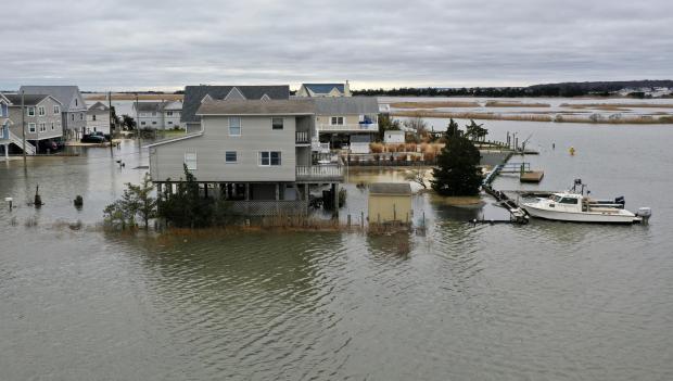
October was a tale of two half-months. Summer-like weather prevailed through the 11th, quickly transitioning to fall-like conditions on the 12th. Passage of the first strong cold front of the season was responsible for the change. Moderate to heavy rain accompanied the front in northwest NJ during the daytime hours of the 11th. That evening, and into the morning of the 12th, moisture from the remnants of once major Hurricane Michael ran up against the front and brought heavy rain to south Jersey. This one-two punch was followed on the 17th by the first freezing temperatures of the season at a few locations and a more widespread freeze on the 19th. Generally cool conditions prevailed the remainder of the month. The remnants of yet another major hurricane, Willa, provided energy and moisture to a quick-hitting nor’easter on the morning of the 27th that brought some of the worst coastal flooding since Sandy in 2012. Michael was an Atlantic storm that made landfall in the Florida panhandle, while Willa was an eastern Pacific storm that came ashore on the west coast of Mexico.

Pages

Subscribe to RSS - News