“Holding On.” Perhaps you’re a bit perplexed attempting to interpret the title of this month’s report. Something with respect to temperature? Certainly, the warm season hardly relinquished its grip on the Garden State during the past month. September temperatures averaged above normal, mainly due to the second half of the month being warmer than the first half. Normally the second half averages approximately 5.0°–5.5° cooler than the first, however this year’s second half was 1.0°–1.5° milder than the first half in the north and about 2° milder in the south. Something regarding precipitation? It was the second consecutive month with below-normal statewide precipitation, with eleven of the past thirteen months having below-normal precipitation. The month ended with most of north Jersey categorized on the US Drought Monitor as being Abnormally Dry or in Moderate Drought, and October 1st found the NJ Department of Environmental Protection declaring a Drought Watch across the entire state. Despite this, the state has not slid into a significant drought situation as is currently found in New England. Water resources are holding on but certainly are more vulnerable than anyone would like.
Statewide, the September temperature averaged 68.1°. This was 1.2° above the 1991–2020 normal and ranked as the 16th warmest September since records commenced in 1895. Ten of the twenty warmest Septembers have occurred since 2010. The average high was 78.0°, which is 0.8° above normal and ranks as the 26th warmest on record. The average low was 58.2°, which is 1.6° above normal and ranks as 12th warmest. The northern climate division averaged 66.9° (+2.0°, 8th warmest), the southern division 68.8° (+0.7°, 25th warmest), and the coastal division 69.0° (+0.3°, 28th warmest).
Monthly precipitation came in below normal at 3.03” (Figure 1). This was 1.13” below normal and ranked as the 56th driest of the past 131 Septembers. The north was driest, averaging 2.53” (-1.93”, 40th driest), the south 3.24” (-0.75”, 62nd driest), and the coast 3.98” (+0.09”, 93rd driest or 39th wettest).
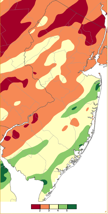
Figure 1. September 2025 precipitation across New Jersey based on a PRISM (Oregon State University) analysis generated using NWS Cooperative, CoCoRaHS, NJWxNet, and other professional weather station observations from approximately 8 AM on August 31st to 8 AM on September 30th. Note the scale in inches at the bottom of the map. Totals range from 1.00”–1.99” (dark red) to 5.00”–5.99” (dark green).
Temperature
There were six days in the first half and another six days in the second half of September where one or more of the 69 Rutgers NJ Weather Network (NJWxNet) stations reached a high of 85° or greater. Even more illustrative of the “backwards” nature of early fall temperatures: the first half of the month had eight days with station lows less than 45°, but only three such days in the second half.
The first 85° or warmer day was the 4th, with four stations at 86°. Sicklerville (Camden County) led the way at 90° on the 5th, with 37 stations maxing out from 85°–89°. The 6th was the warmest September day, with Sicklerville at 93°, 18 stations from 90°–92°, and 27 at 85°–89° (Figure 2). A sea breeze kept Seaside Heights (Ocean) coolest at 73°. Lower Alloways Creek Township (Salem) reached 85° on the 11th and 87° on the 12th, when Piney Hollow (Gloucester) hit 85°. Lower Alloways Township again led the way on the 14th at 87°, followed by seven stations from 85°–86°.
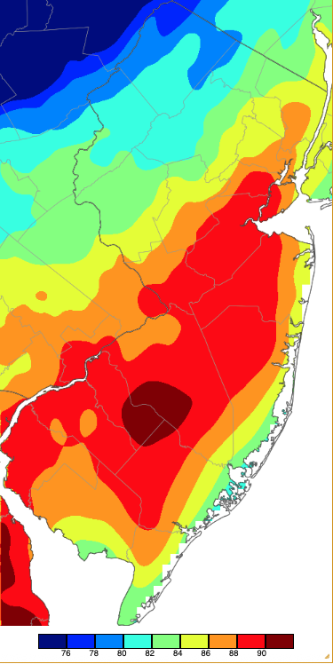
Figure 2. Maximum temperatures on September 6th based on a PRISM (Oregon State University) analysis generated using NWS, NJWxNet, and other professional weather stations. Note the 2° scale beneath the map.
Warmth resumed on the 18th, when up north, Hackettstown (Warren), Pequest (Warren), and Hillsborough/Duke (Somerset) all topped out at 86°, with nine stations at 85°. Oswego Lake (Burlington) may have seen the year’s last 90° high, reaching that level on the 19th, when 40 stations rose to 85°–89°. Pennsauken (Camden) reached 88° on the 23rd, with 28 stations from 85°–89°. Hammonton (Atlantic), Piney Hollow, and Sewell (Gloucester) all reached 85° on the 25th. Lower Alloways Creek Township got to 86° on the 26th, with ten stations at 85°. Finally, Haworth (Bergen) was warmest at 88° on the 28th, with 26 stations from 85°–87°.
As is found often, particularly in rather dry months without too much wind, the valleys of northwest NJ dominated in the low temperature realm this September. Clear, calm nights resulted in cool air filling the valleys, leaving hilltops milder and, with water temperatures slow to relinquish summer warmth, coastal nights remaining mild. The 1st found Walpack (Sussex) down to 43° and Sandyston (Sussex) 45°. Meanwhile, Seaside Heights and Harvey Cedars (Ocean) only fell to 64°. The latter two locations only made it down to 67° on the 2nd while Walpack again reached 43°, Pequest 44°, and Sandyston 45°. Walpack reached 44° on the 3rd. Just three days following the warmest day of the month, the 9th was the coolest morning of the month. Walpack fell to 38°, seven sites were 40°–45°, and 18 from 46°–49° (Figure 3). Sea Girt (Monmouth) was mildest at 67°. The 10th found Walpack at 44°, Sandyston was 43° on the 11th, and Walpack 44° on the 12th.
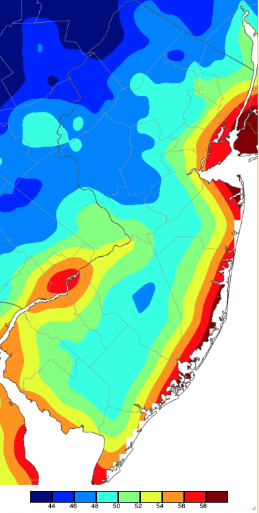
Figure 3. Minimum temperatures on September 9th based on a PRISM (Oregon State University) analysis generated using NWS, NJWxNet, and other professional weather stations.
Cool mornings resumed from the 20th–22nd. Walpack fell to 39° on the 20th, with Sandyston and Pequest each 44°. Walpack reached 42° and Sandyston 43° on the 21st, with 21 stations from 46°–49°. Lows of 44° were observed at Hopewell Township (Mercer), Basking Ridge (Somerset), and Walpack on the 22nd, with five locations at 45°.
Precipitation and Storms
As Figure 1 depicts, September was a month with a dry north and relatively wet southeast. The five wettest Community Collaborative Rain, Hail, and Snow Network (CoCoRaHS) and NJWxNet monthly totals included Little Silver (Monmouth) 6.40”, Port Republic (Atlantic) 5.65”, Dennis Township (Cape May) 5.54”, Eatontown (Monmouth) 5.21”, and Jackson Township (Ocean) 5.09”. On the dry side, three Vernon Township (Sussex) gauges received just 1.46”, 1.55”, and 1.62”. Frelinghuysen Township (Warren) saw 1.48”, Cherry Hill (Camden) 1.62”, Oakland (Bergen) and Blairstown Township (Warren) each came in with 1.65”, Pennsauken 1.69”, and Newton (Sussex) 1.74”.
There were five events during the month where over an inch of rain fell at multiple locations. As the following maps show, despite these heavier episodes, with a few gauges catching more than 3.00” during three of them and just under this mark in another, none of these hefty totals were particularly widespread. The first event was associated with a squall line moving through the state during the afternoon of the 4th followed by some light rain that fell into the predawn of the 5th. Heaviest rainfall totals were in the northwest, with reports of strong wind and small hail (Figure 4). Franklin Township (Warren) caught 2.88” of rain, Hackettstown 2.86”. Mansfield Township (Warren) 2.83”, and Mount Olive Township (Morris) 2.72” and 2.70” (two stations). Thirteen of 281 CoCoRaHS station reports came in with 2.00”–2.88” and 62 from 1.00”–1.99”.
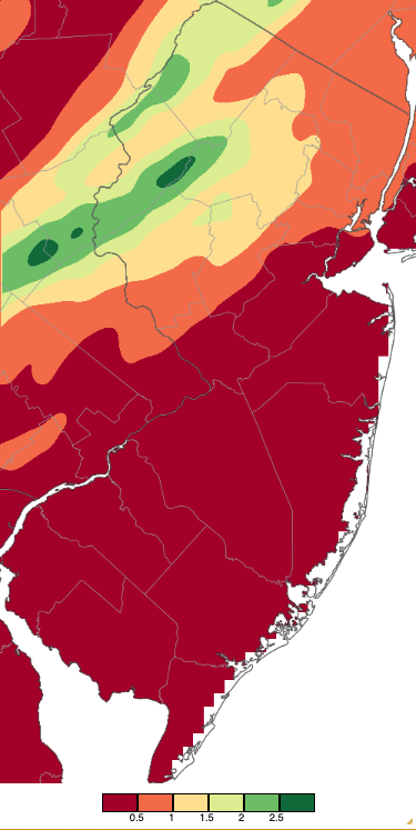
Figure 4. Precipitation across New Jersey from 8 AM on September 4th through 8 AM September 5th based on a PRISM (Oregon State University) analysis generated using NWS Cooperative, CoCoRaHS, NJWxNet, and other professional weather station observations. Note the scale in inches beneath the map.
The most widespread and locally damaging event of the month occurred during the afternoon of the 6th through the morning of the 7th. Strong thunderstorms brought down limbs, trees, and wires, while also causing some minor structural damage in Hunterdon, Somerset, Middlesex, Burlington, and Ocean counties. Wind gusts in the afternoon and evening storms reached 59 mph at Seaside Park (Ocean), New Brunswick (Middlesex) 42 mph, and Fortescue (Cumberland) 41 mph. Some early-evening hail was reported in Hillsborough Township (Somerset) and Franklin Township (Somerset). Little Silver received 4.47”, followed by Pemberton (Burlington) 3.90”, Eatontown 3.51”, Jackston Township 3.43”, Medford Lakes (Burlington) 3.38”, and Monroe Township (Gloucester) 3.19” (Figure 5). Of 270 reports, 16 stations received 2.00”–2.99” and 121 from 1.00”–1.99”.
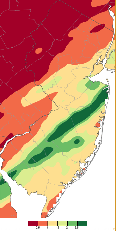
Figure 5. Precipitation across New Jersey from 8 AM on September 6th through 8 AM September 8th based on a PRISM (Oregon State University) analysis generated using NWS Cooperative, CoCoRaHS, NJWxNet, and other professional weather station observations. Note the same scale in inches beneath the map as in Figure 4.
The longest duration event of the month was mainly a southern one. Rain began in the morning and afternoon of the 16th and persisted into the 17th, finally bringing areas further north some rain into the afternoon and evening of the 17th. Some strong thunderstorms on the 16th brought winds gusting to 45 mph at Little Egg Harbor Township (Ocean) and 41 mph at Atlantic City Marina (Atlantic). Rainfall was heaviest in Cape May County, where three Middle Township gauges caught 3.28”, 3.18”, and 2.64”, with Dennis Township at 3.16”, and three Lower Township locations with 2.14”, 1.90”, and 1.78” (Figure 6). Thirty-two sites received 1.00”–1.99”.
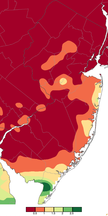
Figure 6. Precipitation across New Jersey from 8 AM on September 16th through 8 AM September 18th based on a PRISM (Oregon State University) analysis generated using NWS Cooperative, CoCoRaHS, NJWxNet, and other professional weather station observations.
The needy north saw modest showers during the evening of the 23rd into the predawn of the 24th, but only Sparta Township (Bergen) with 0.48” and Hardyston Township (Sussex) with 0.45” could muster totals near a half inch. Later on the 24th, afternoon thunderstorms deposited heavy rain in a rather small area of the southeast (Figure 7). Port Republic was soaked with 3.00”, Little Egg Harbor Township 2.60”, Surf City (Ocean) 2.09”, Hamilton Township (Atlantic) 1.93”, and 20 stations from 1.00”–1.75”. Again, mostly in the south, afternoon and evening showers on the 27th persisted into the predawn of the 28th and brought 1.24” and 0.93” to two Lower Township gauges, Middle Township 1.05”, and Ventnor City (Atlantic) 1.00”. None of the other 255 CoCoRaHS reports came in over 0.75”.
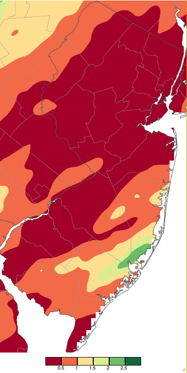
Figure 7. Precipitation across New Jersey from 8 AM on September 24th through 8 AM September 26th based on a PRISM (Oregon State University) analysis generated using NWS Cooperative, CoCoRaHS, NJWxNet, and other professional weather station observations.
The highest barometric pressures of the month were in the 30.30”–30.35” range on the 8th, 9th, and 21st. The lowest pressures of 29.70”–20.80” were observed on the 4th and 25th. Only the wind gusts on the 6th and 16th exceeded 40 mph or greater at a NJWxNet station in September.
The US Drought Monitor weekly map covering the last week of September (Figure 8; data valid September 30th) shows Moderate Drought (D1) coverage in a northern swath and a second area in and near Mercer County. These conditions have an expected recurrence interval of approximately 6–10 years. Much of the remainder of north Jersey, along with locations in Camden and Gloucester counties and along the immediate north and central Ocean County coast, are classified as Abnormally Dry (D0), with conditions expected approximately every 3–5 years. The dry conditions over much of New Jersey and the persistently slow recharge of ground water in the southeast from the drought of last fall into early spring led to the October 1st Drought Watch declaration across the entire state.
The dry weather helped to fuel a wildfire that erupted in West Milford (Passaic) on September 2nd. Named the Buckabear Wildfire, it was 90% contained by September 6th, by which time it had burned through 200 forested acres without causing any structural damage.
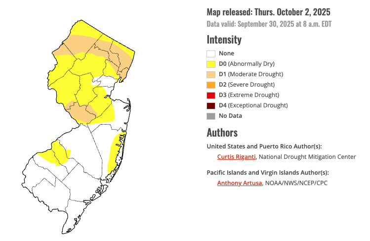
Figure 8. U.S. Drought Monitor map of conditions in NJ as of September 30, 2025.


