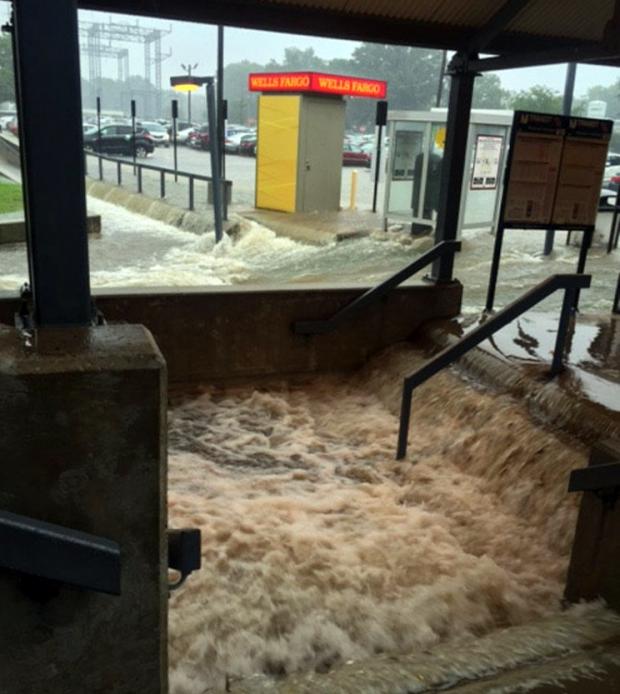
Rushing water floods parts of the Princeton Junction rail station on July 30 (photo by Michael Mancuso/NJ.com).
Overview
The second half of the 2016 NJ weather and climate year began with plenty to talk about. Maximum temperatures were 90° or higher somewhere in the state on 20 afternoons. This, along with many warm nights, helped boost the mean monthly temperature into the top 10 (9th warmest) based on statewide records back to 1895 (Table 1). Yet, remarkably, this was only NJ’s 5th warmest July in the past 11 years. The 77.2° mean was 2.2° above the 1981–2010 average.
| Rank | Year | July Avg. Temp. |
|---|---|---|
| 1 | 1955 | 79.0° |
| 2 | 2011 | 78.8° |
| 3 | 2010 | 78.7° |
| 4 | 1999 | 78.4° |
| 5 | 2013 | 78.2° |
| 6 | 2012 | 78.1° |
| 7 | 1949 | 77.8° |
| 8 | 2006 | 77.3° |
| 9 | 2016 | 77.2° |
| 10 | 1994 | 77.1° |
Table 1. The ten warmest Julys across New Jersey since 1895.
On 15 July days an inch or more of rain fell somewhere in NJ. This included eight days with greater than 2” in spots and four days where a few locations exceeded 4”. Statewide, the average rainfall was 6.85”. This was 2.33” above average and ranks as the 14th wettest July since 1895 (Table 2). It was the wettest July since 2004, and the 4th wettest in the past 41 years. The northern half of the state (Mercer/Somerset/Union northward) averaged 7.27” (+2.49”, 14th wettest), while the southern region averaged 6.77” (+2.38”, 12th wettest). This all came in a month where the northern half of the state remained classified as being in moderate drought (D1) on the US Drought Monitor, with about half of south Jersey considered abnormally dry (D0). Also, on July 26th the NJ Department of Environmental Protection placed the northern half of the state in a drought watch. These actions were the result of notable rainfall deficits dating back to the early spring, with the warmth of the month exasperating low soil moisture, stream flow, ground water, and reservoir conditions. Clearly, the late-month heavy rainfall in a good portion of the state warrants a re-evaluation of drought status as NJ heads into August.
| Rank | Year | July Avg. Precip. |
|---|---|---|
| 1 | 1897 | 11.04" |
| 2 | 1969 | 9.60" |
| 3 | 1945 | 9.56" |
| 4 | 1975 | 9.06" |
| 5 | 1938 | 8.86" |
| 6 | 1919 | 8.11" |
| 7 | 1960 | 7.40" |
| 8 | 1959 | 7.35" |
| 9 | 2004 | 7.28" |
| 10 | 1996 | 7.20" |
| 11 | 1925 | 7.13" |
| 12 | 1984 | 7.05" |
| 13 | 1942 | 6.94" |
| 14 | 2016 | 6.85" |
| 15 | 1941 | 6.76" |
Table 2. The 15 wettest Julys across New Jersey since 1895.
Temperature
While the July 2016 heat was excessive, this year is the only one in the top 10 not to have at least one day where the temperature somewhere in the state exceeded 100°. The other nine years had monthly maximum temperatures ranging from 102° to 108°. This year, Newark Airport (Essex County) reached 99° on the 25th for the hottest maximum, with 98° being achieved elsewhere on the 23rd and 28th. Helping 2016 make the top ten without reaching the century mark were 11 afternoons where the temperature topped out at 95° or higher at one or more locations. This is based on the 60 NJWxNet stations though the 9th, when Walpack (Sussex) had a sensor failure for the remainder of the month. Newark Airport was also examined on extreme days, but is not included in the counts of 95° plus days that follow.
Hawthorne (Passaic) reached 96° on the 6th, with four stations at 95° and 43 of the 59 NJWxNet stations in the 90°s. Logan (Gloucester) and South Harrison (Gloucester) got to 95° on the 8th, when Seaside Heights (Ocean) only reached 79°. Sixteen of the last 18 days of July got to 90°. Six stations reached 95° on the 14th, with 41 sites in the 90°s. A similar situation arose on the 15th, with West Creek (Ocean) at 95° and 41 stations in the 90°s. Sicklerville (Camden) got to 96° and Cherry Hill (Camden) to 95° on the 16th. Logan topped out at 97° and six locations at 95° on the 18th, with 47 stations in the 90°s.
Hawthorne and Jersey City (Hudson) hit 97° on the 22nd, with 51 stations in the 90°s. The hottest day of the month was the 23rd, when the 98° mark was reached at Hamilton (Mercer), Hawthorne, Howell (Monmouth), Jersey City, Mansfield (Burlington), New Brunswick (Middlesex), Newark, and Sea Girt (Monmouth), with the last station located at the coast, right behind the dunes. Clearly, a sea breeze was absent, as the only station that failed to reach 90° was High Point Monument (Sussex, at an elevation of 1800’), which made it to 88°. This scorching Saturday was followed on the 24th by 97° at Hawthorne and 96° at five locations. Newark got to 99° on the 25th, with 51 NJWxNet sites in the 90°s, including Hamilton (Mercer), Hawthorne, Pequest (Warren), and South Harrison at 97°. The 28th saw Hawthorne reach 98° and Haworth (Bergen) 96°, with 45 stations in the 90°s.
Not surprisingly, summing up the 90° plus days at National Weather Service Cooperative stations with lengthy records finds an excessive number of such days compared to1981–2010 averages. Newark saw 16 days reach 90° this July compared to an average of 9.7 days. New Brunswick had 16 days (average 8.2), Millville (Cumberland) 15 days (8.7), Atlantic City Airport in Pomona (Atlantic) 12 days (7.8), Charlotteburg (Passaic) 6 days (3.8), Sussex (Sussex) 7 days (4.9), Atlantic City Marina (Atlantic) 2 days (2.6), and High Point (Sussex) 1 day (1.5; note, this station is at 1500’). All-time records were not severely challenged at any of these stations, though New Brunswick was within 3 days of the record 19 days in 1999.
Despite the excessive warmth of the month, there were 11 days with minimums in the upper 40°s or in the 50°s at one or more station. Walpack fell to 51° on the 1st, with Basking Ridge (Somerset) and Pequest at 55°. Walpack was 53° on the 2nd and High Point Monument 55°. The 3rd was the month’s coolest morning, with 47° in Walpack, Pequest 50°, and 29 stations between 51°–59°. Independence Day wasn’t far behind, with Walpack 48°, Pequest and Kingwood (Hunterdon) 52°, and 25 stations from 53°–59°. High Point Monument was 57° on the 10th, Pequest 52° on the 11th, and Basking Ridge 54° on the 12th.
Later in the month, the Monument dropped to 54° on the 20th, with Basking Ridge, Pequest, and Kingwood 55°. Pequest was 53° on the 21st, 58° on the 24th, and 59° on the 28th.
Precipitation and storms
As is to be expected in a summer month, there was a wide variation in precipitation totals around NJ this past July. However, with so many storm events, most everywhere caught several of them, thus with only a few exceptions, most every observing station in the state had average to well-above average monthly totals. On the top end was Princeton (Mercer) with 14.81”, followed by Berkeley Township (Ocean) with 14.59”, Lawrence Township (Mercer) 12.35”, Lambertville (Hunterdon) 11.85”, Plainsboro (Middlesex) 11.56”, and South Brunswick (Middlesex) 10.66”. Exemplifying the local variations, another Berkeley Township station only saw 6.69”, as they were not within the localized area of excessive rainfall on the 31st (more on that later). Meanwhile on the dry side of the ledger, July rainfall amounted to only 1.61” at West Cape May (Cape May), 1.92” in Wildwood Crest (Cape May), Middle Township (Cape May) 2.68”, Liberty Township (Warren) 3.36”, and Hackettstown (Warren) 3.48”.
The parade of precipitation events where an inch or more accumulated at CoCoRaHS or NJWxNet stations began on the afternoon and evening of the 1st. Some 43 of 211 CoCoRaHS reports exceeded an inch, primarily along the northern tier of NJ, and in Monmouth and Atlantic counties. Rumson (Monmouth) led the way with 3.14”, followed by several other Monmouth County locations, including Colts Neck 2.83”, Oceanport 2.57”, and Red Bank 2.50”, along with 2.36” in Mullica (Atlantic). Nickel size hail was observed in Hamilton (Mercer), with pea size hail in Mt. Laurel (Burlington). Winds gusted to 49 mph at Fortescue (Cumberland) and 40 mph in Oceanport, with tree damage and power outages reported in seven counties scattered throughout the state. Several areas in south and west portions of the state received less than 0.10”.
Firework celebrations were dampened or canceled due to late afternoon and evening showers on the 4th. Most of NJ saw at least 0.50”, led by Sea Isle City (Cape May) with 2.71”, Woodbine (Cape May) 2.50”, and Bivalve (Cumberland) 2.46”.
Heavy rain returned in the afternoon of the 8th through the pre-dawn hours of the 9th. An odd alignment of the heaviest totals extended from southern Hunterdon south/southeast to northern Atlantic County where 4.10” fell at Egg Harbor City. Other hefty totals included Lambertville 2.94”, Flemington (Hunterdon) 2.80”, and Mt. Laurel 2.65”. Up in Sussex County, 2.72” fell in Hardyston, another of the 44 out of 211 CoCoRaHS stations over 1.00”. Tree damage and power outages were reported in Morris and Atlantic counties. No rain fell in southwest and northeast regions.
The afternoon of the 9th into the predawn of the 10th saw 1.67” accumulate in Rockaway Township (Morris), 1.23” in Lawrence Township, and 1.17” at Wantage (Sussex). The northern tier of counties, along with Mercer and Salem counties, saw the most rain. Winds felled trees and power lines in these counties, and also in Monmouth and Cumberland counties. The far south, along with Camden and Gloucester counties, saw little action.
Mercer, Hunterdon, and Somerset counties saw rain during the afternoon and evening of the 13th, while little or none fell elsewhere. Lambertville caught 1.65”, with two Hopewell Township (Mercer) stations reporting 1.05” and 0.97”. A more substantial event occurred to the north in the corridor between Interstates 78 and 80 on the 14th. This included the first confirmed NJ tornado since October 7, 2013. Rainfall wasn’t too heavy, with 1.19” topping the list at Washington (Warren) and 1.04” in both Long Hill Township (Morris) and Washington Township (Morris). An EF0 tornado with estimated winds topping out close to 75 mph touched down in White Township (Warren) at 2:46 PM. It was estimated to be 75 yards wide and traveled a 2.8-mile route. In addition to tree/building damage and power outages associated with the tornado, there were many damage reports in Warren, Morris, Union, and Essex counties. A 42 mph gust was observed in Lyndhurst (Bergen). Fortunately, there were no deaths or major injuries reported.
Late afternoon and evening storms on the 16th brought down trees and disrupted power in Camden, Burlington, and Monmouth counties. There was a bulls-eye of heavy rain in eastern Camden County that spread into adjacent areas. There was also a heavy patch in southern Monmouth and north Ocean counties. Little rain fell in the northern third of NJ or along the southern coast. Berkeley Township led the way with 3.15”, with a wind gust of 57 mph. Evesham (Burlington) saw 2.49”, Franklin (Gloucester) 2.05”, Silas Little (Burlington) 2.03”, and Sicklerville 1.91”. In Point Pleasant Beach (Ocean), in a span of ten minutes, two women suffered minor injuries when struck by lightning during a mid-afternoon storm.
Late afternoon storms on the 18th afflicted eastern Atlantic and northern Cape May counties and scattered regions elsewhere. The least action was found in northern coastal counties and the Highlands. Wantage caught 1.41”, Woodbine 1.24”, Port Republic (Atlantic) 1.19”, and High Point 1.08”. Damaging winds were observed in a number of locations, with gusts of 68 mph in Linden (Union), 65 mph at Newark, Fortescue 53 mph, Harvey Cedars (Ocean) 51 mph, Pittstown (Hunterdon) 45 mph, Woodbine 45 mph, and Kingwood and Logan each 40 mph. Trees were toppled, buildings damaged, and power outages observed in at least 11 counties. Tragically, a woman was electrocuted in Fanwood (Union) as she attempted to exit her car after a live power line fell on top of it during a storm.
Late afternoon thunder boomers on the 23rd saw winds gust to 54 mph at Logan, 47 mph at Oswego Lake (Burlington), and 43 mph in Woodbine, with damage reported in multiple counties. Evesham Township saw 1.23” and Cherry Hill 1.05”.
A storm in the pre-dawn hours of the 25th deposited 1.81” and 1.54” at two Toms River (Ocean) stations, with Medford Lakes (Burlington) receiving 1.62”, Ewing (Mercer) 1.32”, and Moorestown (Burlington) 1.31”. A more substantial event occurred during the late afternoon and evening of the 25th. It included the second tornado of the month and July’s strongest widespread winds, with many reports of building and tree damage and power outages in over half of NJ’s 21 counties. The tornado was rated EF1, with peak winds of approximately 90 mph. It touched down in Readington Township (Hunterdon) at 5:12 PM and remained on the ground for 3.49 miles to Branchburg (Somerset). Maximum width was 75 yards. Pea size hail was reported in Howell and Hillsborough (Somerset). Winds gusts included 58 mph at Port Monmouth (Monmouth), 47 mph in Fortescue, Mullica 44 mph, Upper Deerfield (Cumberland) 43 mph, Sea Girt 42 mph, Hillsborough and Pittstown 41 mph, and Mannington Township (Salem) 40 mph. Twelve other NJWxNet stations gusted in the 30–39 mph range. Rainfall exceeded 1.00” at 78 of the 219 reporting CoCoRaHS stations. This includes 2.27” at Cranbury (Middlesex), East Windsor (Mercer) 2.23”, Hopewell Township 2.22”, and Brick Township (Ocean) 2.12”. No rain was observed in the far south and far north.
Afternoon storms on the 27th gave Pitman (Gloucester) 1.23” and two Sea Isle City locations 1.14” and 0.96”. This was a minor precursor to a significant south Jersey event that began during the afternoon of the 28th and lasted into the morning of the 29th. Over this interval, 74 of 210 CoCoRaHS reports exceed an inch, with heaviest rains in Gloucester, Salem, Cumberland, and central Cape May counties in the south and in western Monmouth and western Ocean counties further north. The far northwest and northeast corners of the state collected an inch or more, while elsewhere in the north 0.25”–0.50” totals were most common. Mannington topped the list with 4.93”, followed by Dennis Township (Cape May) with reports of 3.63” and 3.14”. Washington Township (Gloucester) came in with 3.55”, Franklin Township (Gloucester) 3.54”, and Pitman 3.18”.
The action shifted to central and northern NJ from the late morning to late evening of the 30th, and reignited during the early morning into midday on the 31st in portions of Ocean and Hunterdon counties. Given that rain persisted in one location or another for more than 24 hours, two-day totals are provided, along with a few values for specific periods during this onslaught. Fourteen CoCoRaHS or NJWxNet stations had two-day totals exceeding 5.00”. Topping the list was Princeton with 7.77”, followed by Ringwood (Passaic) 6.92”, Berkeley Township 6.55”, Lebanon (Hunterdon) 5.94”, Pittstown 5.92”, Bloomingdale (Passaic) 5.79”, Plainsboro 5.72”, Flemington 5.60”, and Oakland (Bergen) 5.56”. Twenty-three of the 207 CoCoRaHS stations had two-day totals between 3.00”–4.99”, 40 were between 2.00”–2.99”, and 63 from 1.00”–1.99”. Only the far south emerged from this without at least several tenths of an inch of rain.
The initial deluge occurred in the Route 1 corridor of central NJ. In a few hours during the afternoon of the 30th, a thunderstorm complex stalled and deposited 7.23” at Princeton and 5.15” in Plainsboro. South Brunswick (Middlesex) also received 5.03” and North Brunswick (Middlesex) 4.90”. Storms erupted farther north at this time, with trees coming down and power outages reported in the Morristown (Morris) area. Rain also fell heavily over the Highlands from the evening into the early morning hours of the 31st, providing some of the two day totals noted above in Passaic and Bergen counties. As dawn arrived on the 31st, very slow-moving thunderstorm cells generated flooding rains in a small area of Ocean County and a portion of Hunterdon County. Berkeley Township was inundated with 6.48” and Pittstown 3.52”. Flash flooding occurred with each of these events, resulting in some water rescues; however, there were no injuries or loss of life. Minor flooding followed on the Millstone River, with action stages reached on portions of the Raritan River in central NJ.
The barometric pressure didn’t fluctuate greatly during July. Maximum pressures were about 30.25” on the 20th and at their lowest were in the 29.70”–29.75” range on the 7th. Days with wind gusts exceeding 40 mph were all mentioned in the storm event summaries.


