The following report was written by Erica Langer, a University of Wisconsin-Madison senior, based on research performed during 2-month internship at the Office of the NJ State Climatologist
Overview
Human-induced climate change is no longer an abstract concept or a threat to be faced in the future. It is currently changing the workings of Earth’s atmosphere and causing extremes in weather events (Arguez et al. 2012). It is the warming of the environment from human activity that is indicated through variables such as temperature, precipitation, and sea level. This global phenomenon influences regional climates. In particular, New Jersey has been one of the fastest warming states throughout the country (New Jersey Department of Environmental Protection 2020) and observing how is fundamental in understanding how climate change is affecting the natural state of the environment.
When one looks to observe how the climate of New Jersey has changed, one way to explore any adjustment in the climate system is by examining climate normals. These normals reflect 30-year averages of weather observations. They are the basis for judging how daily, monthly, and annual weather conditions compare to what is “normal” for a specific location in today’s climate. Normals provide a baseline that allows an individual to compare a location's current weather to average conditions one would expect to see. Normals are updated every ten years at (e.g., 1991–2020), similar to how a Census provides an updated snapshot of the populace and economy of the United States. They replace the previous 30-year normals (e.g., 1981–2010), and are calculated within the United States and elsewhere around the world. Gaining new information from them every ten years is useful in the work of public and private stakeholders, including the energy and agricultural sectors of the U.S. economy, building design, infrastructure, construction, and many governmental organizations such as the United States Department of Agriculture and Department of Health and Human Services.
Official 1991–2020 normals for the United States have recently been generated at NOAA's National Centers for Environmental Information (NCEI) and are available for New Jersey on the website of the Office of the NJ State Climatologist. Included are annual, seasonal, monthly, and daily normals of temperature, precipitation, and other climatological variables from various NJ stations, counties, climate divisions, and for the state as a whole.
In this report, a comparison of statewide temperature and precipitation normals between 1981–2010 and 1991–2020 periods is provided. It will be shown that the primary outcome is a statewide increase in temperature and precipitation as 2011–2020 observations replace those from 1981–1990 in the latest 30-year period.
How are the Data Obtained?
The statewide normals presented in this report are based on the nClimDiv monthly division dataset, which is maintained by NCEI. nClimDiv is a gridded product derived from area-weighted averages of 5 km x 5 km grid-point estimates taken from monthly weather station data (Vose et al. 2018). Station data are then gridded via climatologically-aided interpolation to minimize biases from topographic and network variability. Monthly divisional and statewide gridded temperature and precipitation values are then averaged over the full normals period (e.g., each January statewide value over thirty years) to obtain the statewide monthly normal (Vose et al. 2018). The networks used for the dataset include the National Weather Service (NWS) Cooperative Observer (COOP) Network that consists of stations operated by volunteers and the NWS Automated Surface Observing Systems (ASOS) network (Vose et al. 2014). For this report, the data presented are the 1981–2010 and 1991–2020 nClimDiv statewide normals.
Differences between the 1981–2010 and 1991–2020 normals are a function of swapping out 1981–1990 observations and replacing them with 2011–2020 observations. The intervening 20-year interval of 1991–2010 is two thirds of each 30-year normals period.Thus, the results and comparisons in this study are essentially comparisons between the first and last decades of this overall 40-year period (1981–2020). Therefore, in addition to looking at the standard 30-year normals and their comparison, an examination of the first and last decades will be made.
Changes in Normals from 1981–2010 to 1991–2020
Average Temperature:
The New Jersey annual average temperature for the 1991–2020 normals period of 53.56 °F is 0.70 °F warmer than the 1981–2010 normal of 52.86 °F.The monthly temperature differences between the two normals periods ranges from zero in November to as much as 1.4 °F in December.
The monthly normals for the two periods are plotted alongside each other in Figure 1, while Figure 2 shows the monthly differences between the two.
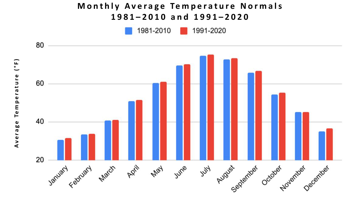
Figure 1. NJ monthly average temperature normals for the 1981–2010 and 1991–2020 periods.
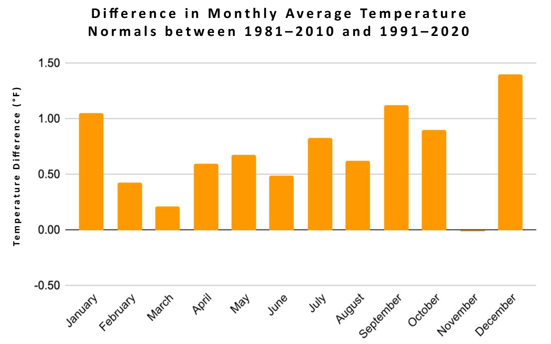
Figure 2. Monthly differences in average temperature normals between the 1981–2010 and 1991–2020 periods. Positive values indicate the more recent 30-year interval is warmer than the prior one.
The annual rise and fall of temperature certainly dominates the first figure, while the second shows the full range of monthly temperature differences between the two normals periods in addition to the November and December extremes mentioned previously. Two swing season months, November and March, show the smallest differences, while early/mid-winter (December–January), mid-summer (July), and early/mid-fall (September–October) show the largest changes.
Again, the differences between the two 30-year periods are driven by changes between the 1981–1990 and 2011–2020 intervals, as the intermediate two decades are part of each of the normals periods. Thus, Figures 3 and 4, similar to those above, were generated to depict the two exchanged decades.
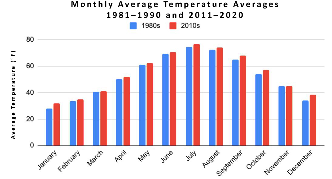
Figure 3. New Jersey monthly average temperature averages for 1981–1990 and 2011–2020.
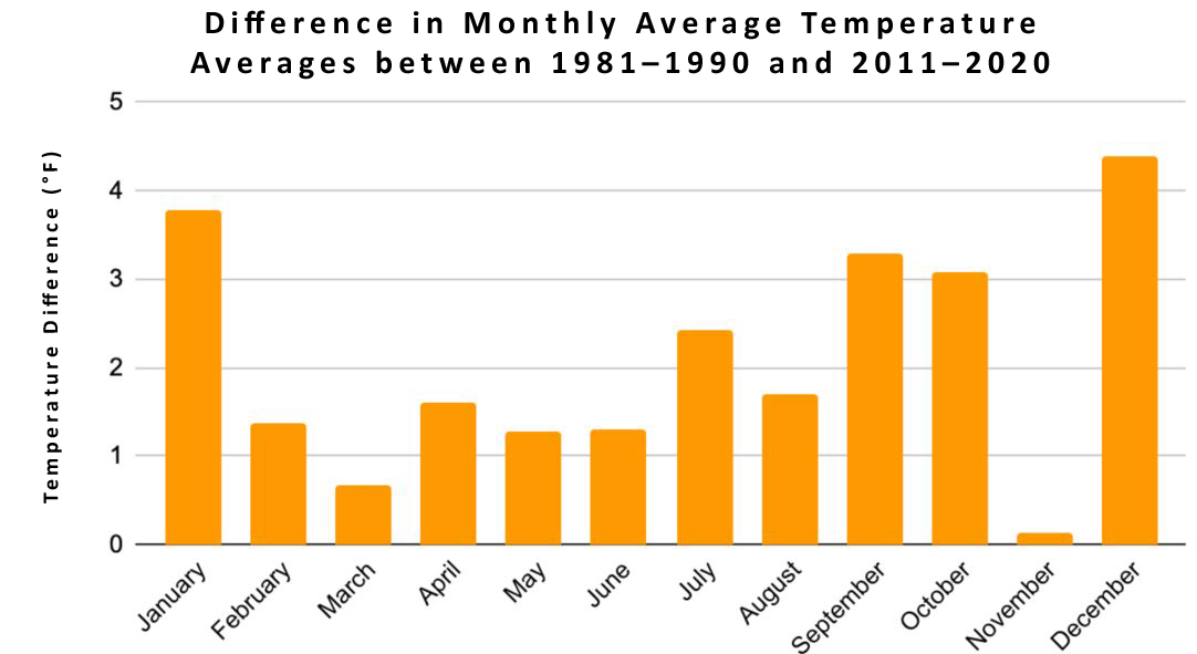
Figure 4. Differences in monthly average temperature averages between 1981–1990 and 2011–2020.
The annual cycle of temperature dominates (Figure 3). This is certainly to be expected, although it is apparent that climatologically cooler months in the 2011–2020 decade are warming to levels that bring them closer with adjacent climatologically-warmer months in the 1981–1990 decade. The absolute monthly differences between the two decades are much larger in Figure 4 than is seen in Figure 2. They range from 0.14 °F warmer in the more recent decade in November to 4.39 °F warmer in December.
From viewing both perspectives of average temperature, the warm season —May to October — is consistently warming. The cool season, November to April, also warms but shows more month-to-month fluctuations than the warm season.
Minimum Temperature:
Minimum temperatures represent the low temperatures of each day averaged over the entire month. The New Jersey annual minimum temperature for the 1991–2020 normals period of 43.55 °F is 0.79 °F warmer than the 1981–2010 normal of 42.76 °F. The monthly temperature differences between the two normals periods ranges from -0.08 °F in November to as much as 1.51 °F warmer in December.
The annual average minimum temperature from 1981–2010 was 42.76 °F compared to 43.55 °F from 1991–2020. The monthly normals for the two periods were plotted alongside each other in Figure 5 while Figure 6 shows the monthly differences between the two.
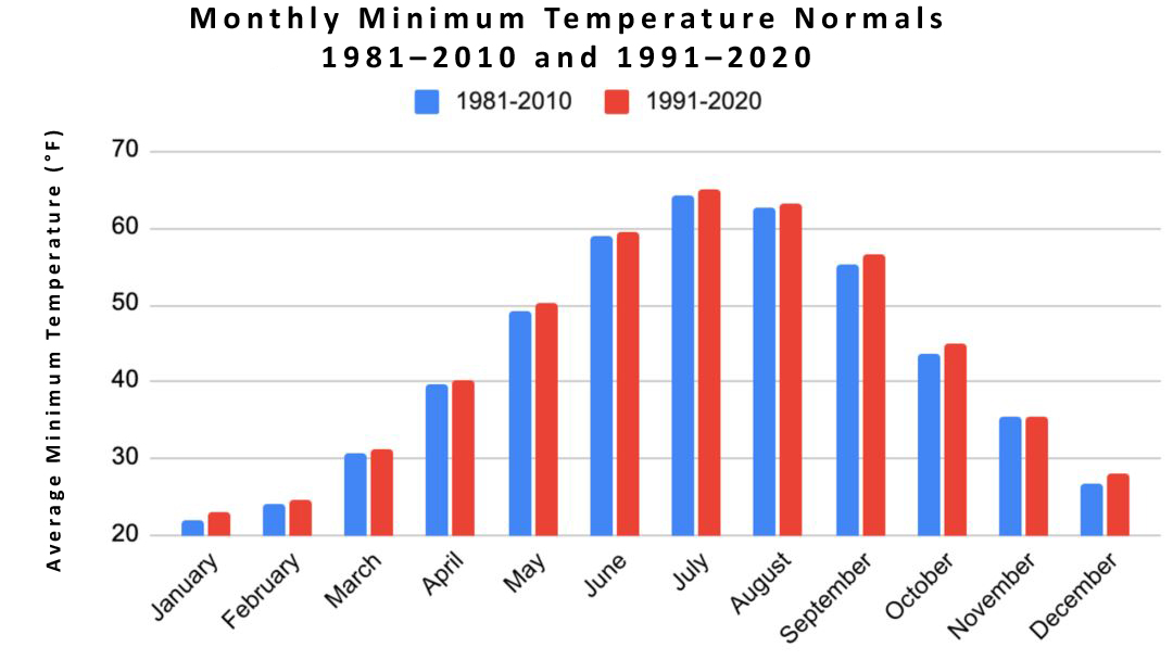
Figure 5. New Jersey monthly minimum temperature normals for the 1981–2010 and 1991–2020 periods.
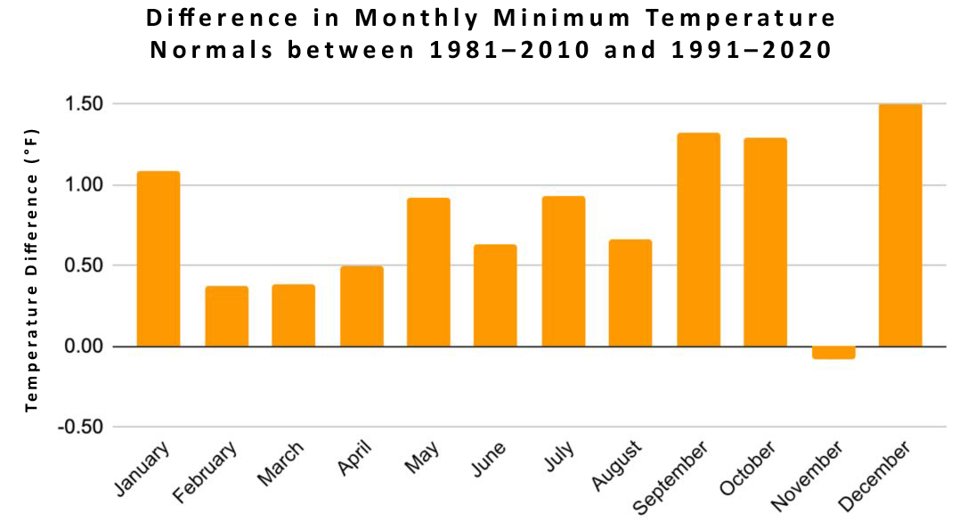
Figure 6. Monthly differences in minimum temperature normals between the 1981–2010 and 1991–2020 periods. Positive values indicate the more recent 30-year interval is warmer than the prior one.
Figure 6 shows warmer minimum temperatures for the most current normals period compared to the previous. This corresponds with the warming trends in the graph of New Jersey average temperatures. Additionally, as stated earlier, the differences between the two 30-year periods are driven by changes between the 1981–1990 and 2011–2020 intervals, as the intermediate two decades are part of each of the normals periods. Thus, graphs similar to those above were generated to depict only the two exchanged decades (Figures 7 and 8).
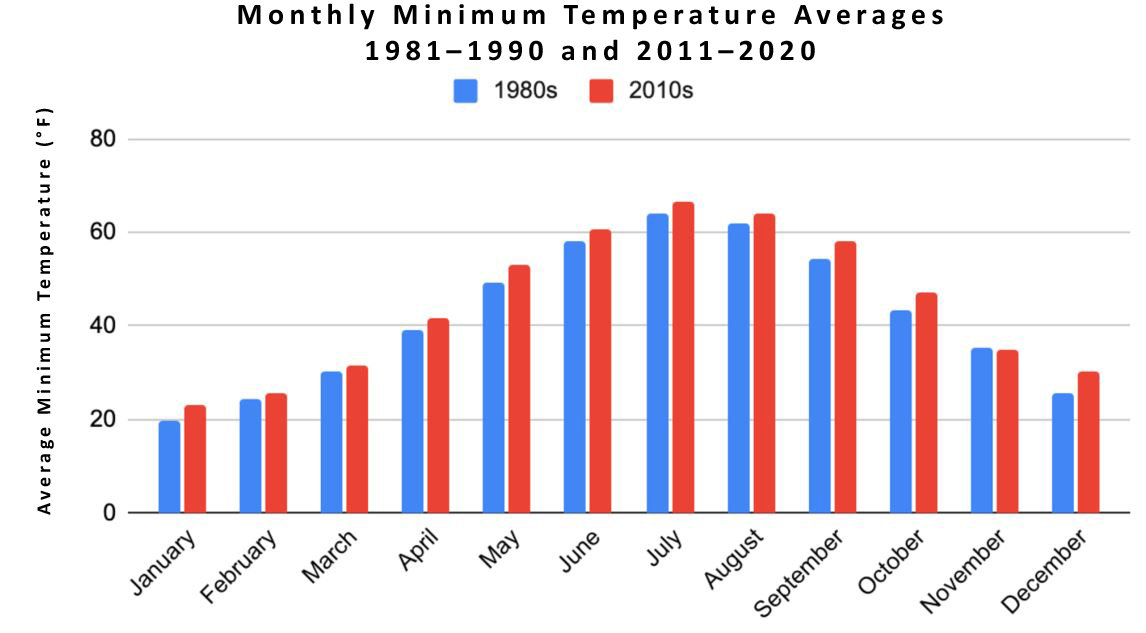
Figure 7. New Jersey monthly minimum temperature averages for 1981–1990 and 2011–2020.
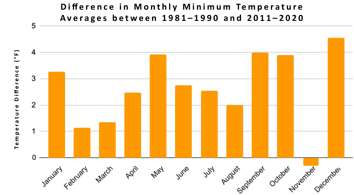
Figure 8. Differences in monthly minimum temperature averages between 1981–1990 and 2011–2020.
The absolute monthly minimum temperature differences between the two decades are much larger in Figure 8 than those seen in Figure 6. They range from 0.24 °F cooler in the more recent decade in November to 4.55 °F warmer in December. As with monthly mean normals, this shows that the warm season is consistently warming while the cool season shows month-to-month fluctuations.
Maximum Temperature:
Maximum temperatures represent the high temperatures of each day averaged over the entire month. The New Jersey annual maximum temperature for the 1991–2020 normals period of 63.56 °F is 0.60 °F warmer than the 1981–2010 normal of 62.96 °F. The monthly temperature differences between the two normals periods ranges from 0.04 °F warmer in November to 1.30 °F warmer in December. As with the means and minimums, the monthly normals for the two periods were plotted alongside each other in Figure 9, while Figure 10 shows the monthly differences between the two.
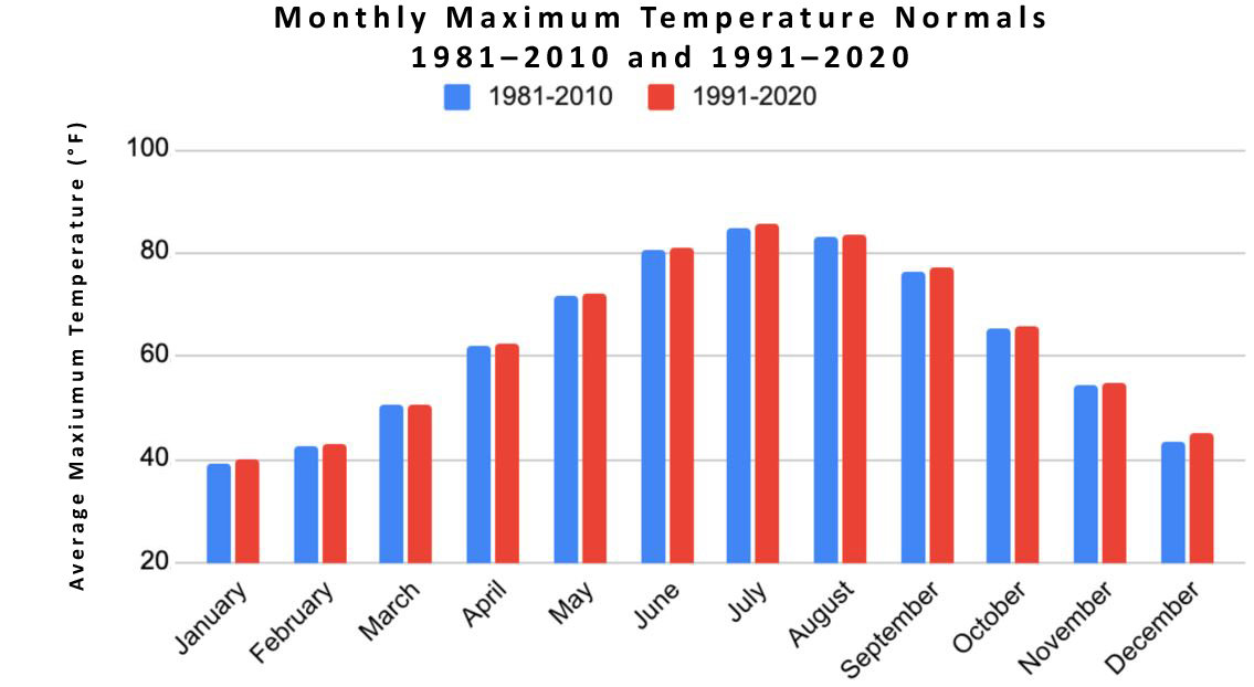
Figure 9. New Jersey monthly maximum temperature normals for the 1981–2010 and 1991–2020 periods.
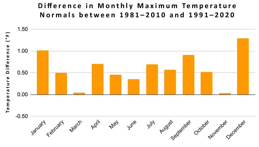
Figure 10. Monthly differences in maximum temperature normals between the 1981–2010 and 1991–2020 periods. Positive values indicate the more recent 30-year interval is warmer than the prior one.
The trend in maximum temperature is quite similar to minimum temperature. Once again, for reasons not yet known, the substantial difference between small changes in November and large ones in December are seen.
As mentioned previously, the differences in the 30-year periods are driven by changes between the 1981–1990 and 2011–2020 intervals. Figures 11 and 12 depict the two exchanged decades. The differences in maximum temperature range from 0.11 °F warmer in November of the more recent decade to 3.9 °F warmer in December. A consistent increase in warm season months differs from a more variable cold-season month-to-month warming.
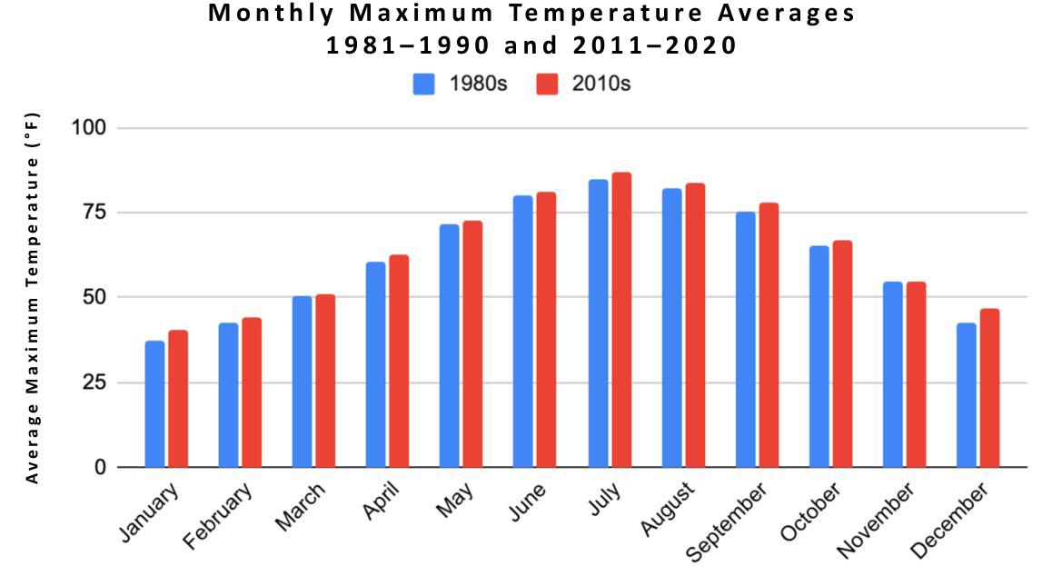
Figure 11. New Jersey monthly maximum temperature averages for 1981–1990 and 2011–2020.
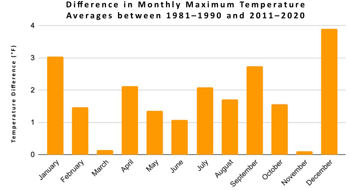
Figure 12. Differences in monthly maximum temperature averages between 1981–1990 and 2011–2020.
The annual warming trend and differences in changes between the monthly normals periods for maximum temperature are very similar to minimum temperature. The annual minimum temperatures rose 0.79 °F while the maximums have increased by 0.60 °F. December shows the most warming for maximums and minimums and November the least warming.
Precipitation:
The New Jersey annual precipitation for the 1991–2020 normals period is 47.56” while the annual precipitation for the 1981–2010 normal is 46.36”. The monthly differences between the two normal periods ranges from zero change to almost 0.50”. The monthly normals for the two periods are plotted alongside each other in Figure 13, while Figure 14 shows the monthly differences between the two. Nine months show increasing precipitation, led by August, while April shows the largest decrease in precipitation.
The overall increase in precipitation for the current normals period may be associated with the increasing warmth that provides the potential for more moisture to be held in the atmosphere thus perhaps enhancing precipitation events. While NJ precipitation normals vary by region, primarily due to topography and proximity to the Atlantic, the trend towards more precipitation has occurred statewide (analyses not shown here).
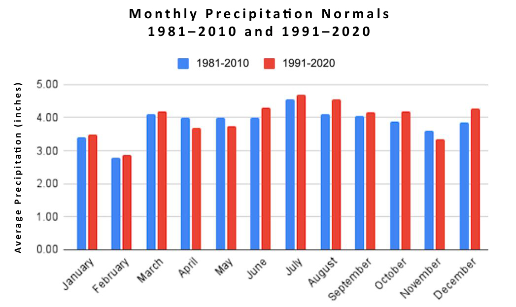
Figure 13. New Jersey monthly total precipitation normals for the 1981–2010 and 1991–2020 periods.
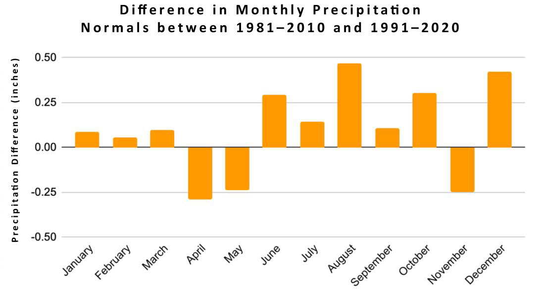
Figure 14. Monthly differences in total precipitation normals between the 1981–2010 and 1991–2020 periods. Positive values indicate the more recent 30-year interval is wetter than the prior one..
Graphs depicting the 1981–1990 and 2011–2020 intervals are presented in Figures 15 and 16. These figures highlight the differences between the decades of the 80s and 10s, with generally wetter average precipitation the 2010s versus the 1980s for all months except for April, May, and November.
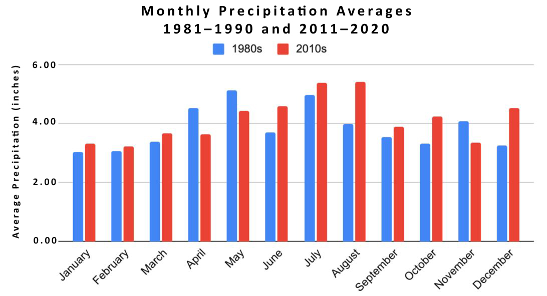
Figure 15. New Jersey monthly precipitation averages for 1981–1990 and 2011–2020.
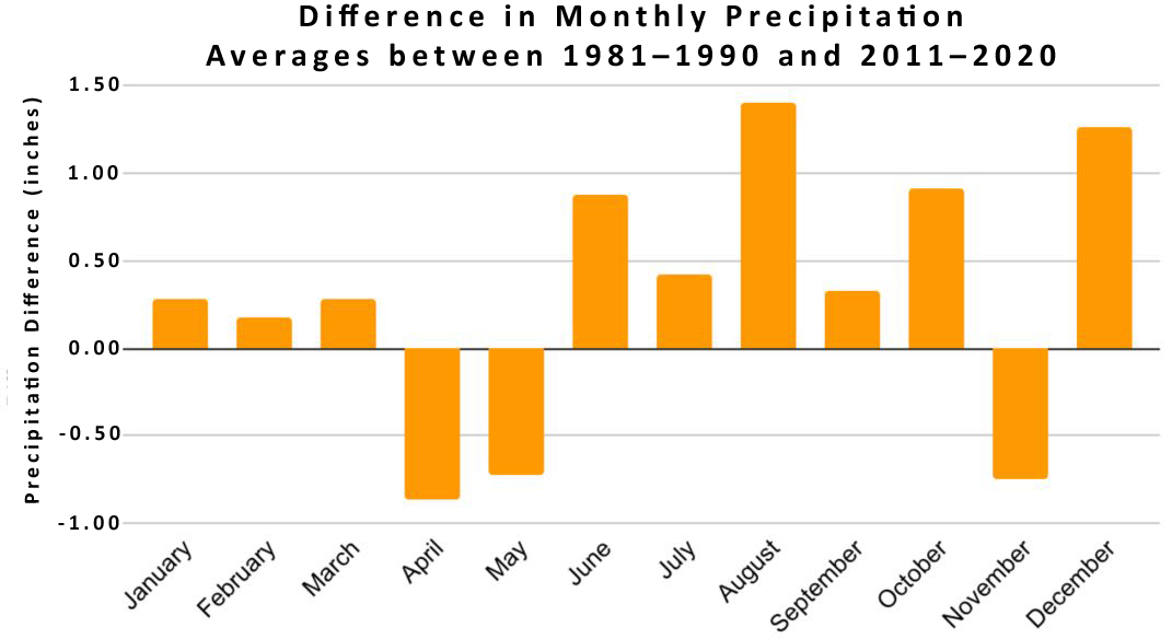
Figure 16. Differences in monthly precipitation averages between 1981–1990 and 2011–2020.
Final Thoughts:
How will the 1991–2020 normals compare with new normals for the 2001–2030 period? Beyond just examining the normals for the two most recent 30-year normal periods that are the focus of this report, longer-term trends are evident across the Garden State since statewide records began in 1895. For temperature, it is one of general increasing warmth, particularly over the past 40 years and even more so this century. For instance, eleven of the fifteen warmest summers have occurred in the past twenty years. The most recent month that falls within the top five for cold weather is December 1989. Since that time, the state has had forty-seven top-five warmest months, demonstrating how the balance has shifted to the warmer side. There is no reason to expect that this trend will not be evident within the next normal period.
And what about precipitation? The past 125 years have shown an approximate 7% increase in precipitation. This is just about what the Clausius-Clapeyron relationship of temperature change to moisture availability should show for New Jersey. Perhaps this is coincidental, but there may be a connection there that warrants further study. So, is it safe to assume that should NJ warm this next decade that precipitation will follow suit? Over such a short period and with the natural variations still clearly seen in the climate system, this is not certain, but it’s something that will continue to be evaluated.
References
Arguez, A., I. Durre, S. Applequist, R. S. Vose, M. F. Squires, X. Yin, R. R. Heim, Jr., and T. W. Owen, 2012: NOAA's 1981–2010 U.S. Climate Normals: An Overview. Bulletin of the American Meteorological Society, 93, 1687–169. doi:10.1175/BAMS-D-11-00197.1 .
New Jersey Department of Environmental Protection. 2020. New Jersey Scientific Report on Climate Change, Version 1.0. (Eds. R. Hill, M.M. Rutkowski, L.A. Lester, H. Genievich, N.A. Procopio). Trenton, NJ. 184 pp.
Vose, R. S., Applequist, S., Squires, M., Durre, I., Menne, M. J., Williams, C. N., Fenimore, C., Gleason, K., & Arndt, D. (2014). Improved Historical Temperature and Precipitation Time Series for U.S. Climate Divisions. Journal of Applied Meteorology and Climatology, 53(5), 1232–1251. https://doi.org/10.1175/jamc-d-13-0248.1 .
Vose, R. S., Applequist, S., Squires, M., Durre, I., Menne, M. J., Williams, C. N., Fenimore, C., Gleason, K., & Arndt, D. (2018, November 15). NOAA Monthly U.S. Climate Divisional Database (NClimDiv). National Centers for Environmental Information (NCEI). https://www.ncei.noaa.gov/access/metadata/landing-page/bin/iso?id=gov.noaa.ncdc%3AC00005 .


