Latest Temperatures

Current Dew Point

Latest Wind Speeds

Wind Gusts

Top Story

Cherry Blossom trees in full bloom at Branch Brook Park in Newark (Essex County) on April 10th. Photo by Tariq Zehawi/NorthJersey.com.

You would never have guessed it by looking at most days, with some wet, some dry, some warm, some cold, but put it all together and a rather normal April temperature- and precipitation-wise emerged from quite a variety of days and weeks. This is often the case during a transitional month (mid-fall or mid-spring), but this month took it to a bit of an extreme. Toss in a partial solar eclipse and an earthquake and it was quite the month for all who enjoy observing our fascinating world and solar system.

April precipitation averaged 4.14” across New Jersey. This is 0.44” above the 1991–2020 normal and ranks as the 42nd wettest of records dating back to 1895. Generally, the north received more rain than the south. The north climate division averaged 4.59” (+0.69”, 40th wettest), south division 3.89” (+0.31”, 48th wettest), and coastal division 3.65” (+0.10”, 61st wettest).

The year-to-date precipitation (rain and melted frozen precipitation) is 19.86”. This is 5.61” above normal and ranks as the 5th wettest January–April period on record. The top total is 22.98” in 1983 and the second through four wettest occurred in 1979, 1958, and 1953. The past 12 months have seen a state average 56.98” of precipitation, which is the 6th wettest of all such May–April periods dating back to 1895.

Latest Extremes

City, State Temp
Fortescue, NJ 53
West Cape May, NJ 52
Seaside Heights, NJ 52
Vineland, NJ 52
Jersey City, NJ 52
City, State Temp
High Point Monument, NJ 42
High Point, NJ 44
Vernon Twp., NJ 44
Chester Borough, NJ 46
Wantage, NJ 46
most current information as of May 10 10:45 AM

Latest Conditions & Forecast

New Brunswick, NJ

Rutgers University Meteorology Program

50°F

Wind

3 mph from the ESE

Wind Gust

17 mph from the ENE

Rain
52 °F
Rain then Slight Chance Rain
45 °F
Partly Sunny
61 °F
Mostly Cloudy then Chance Showers
47 °F
Chance Showers
59 °F
Partly Cloudy
46 °F
Mostly Sunny
75 °F
Mostly Cloudy
56 °F
Mostly Cloudy then Chance Showers
78 °F
Showers Likely
58 °F
Chance Showers
71 °F
Chance Showers
56 °F
Partly Sunny
74 °F

Today

Rain. High near 52. East wind around 15 mph, with gusts as high as 30 mph. Chance of precipitation is 100%. New precipitation amounts between a tenth and quarter of an inch possible.

Tonight

Periods of rain, mainly before 8pm. Low around 45. East wind 5 to 10 mph becoming north after midnight. Chance of precipitation is 80%. New precipitation amounts of less than a tenth of an inch possible.

Saturday

Partly sunny, with a high near 61. Northeast wind around 5 mph becoming east in the afternoon.

Saturday Night

A chance of showers after 2am. Cloudy, with a low around 47. Southeast wind around 5 mph. Chance of precipitation is 30%. New precipitation amounts of less than a tenth of an inch possible.

Sunday

A chance of showers, mainly before 5pm. Cloudy, with a high near 59. East wind 5 to 10 mph. Chance of precipitation is 50%. New precipitation amounts between a tenth and quarter of an inch possible.

Sunday Night

Partly cloudy, with a low around 46.

Monday

Mostly sunny, with a high near 75.

Monday Night

Mostly cloudy, with a low around 56.

Tuesday

A chance of showers after 2pm. Mostly cloudy, with a high near 78. Chance of precipitation is 50%.

Tuesday Night

Showers likely, mainly between 8pm and 2am. Mostly cloudy, with a low around 58. Chance of precipitation is 60%.

Wednesday

A chance of showers. Mostly cloudy, with a high near 71. Chance of precipitation is 50%.

Wednesday Night

A chance of showers. Mostly cloudy, with a low around 56. Chance of precipitation is 40%.

Thursday

Partly sunny, with a high near 74.

Search by zipcode or city/state for the latest conditions, forecasts, graphs, maps and more nearest to you.

More News

Looking south from Island Beach State Park toward Long Beach Island and the Barnegat Lighthouse on March 20th (photo by Dave Robinson).

So much for March flipping from lion to lamb or vice versa. March 2024 was often a lion throughout, with frequent roaring winds and multiple rain events producing a near-record monthly precipitation total and occasional flooding. The first half of the month ran at a record-warm pace, the monthly average later to be tempered by a second half that was cooler than the first. Still, the month emerged as the 9th mildest on record. Befitting the overall mild conditions, snowfall was scarce to non-existent. Winds gusted to 35 mph or higher at one or more Rutgers NJ Weather Network (NJWxNet)...

Sunset at Colonial Park in Franklin Township (Somerset County) on February 15th (photo by Dave Robinson).

Perhaps the title of this report is a bit overstated when it comes to February weather conditions, but not by all that much. However, like much of the coterminous United States, it applies rather appropriately to the December 2023–February 2024 winter. New Jersey’s winter conditions follow at the end of this report, with February discussed first. February 2024 was on the dry side. In fact, the statewide average precipitation (rain and melted snow) of 1.55” was 1.31” below the 1991–2020 normal and ranks as the 12th driest since records began in 1895. The northern climate division averaged...

An ice-encased walkway and railings generated from spray from Great Falls (background) in Paterson (Passaic County) during the cold January outbreak (photo courtesy of Liz Reilly).

The first month of 2024 provided a potpourri of weather happenings, including excessive rainfall and flooding, multiple snowfalls, frequent strong winds, frigid days, occasional warmth, and culminating with persistent dismal (aka damp, cloudy) conditions. Something for anyone or perhaps not favored conditions for most people. Totaling up the multiple precipitation episodes, this month emerged as the 6th wettest January on record dating back to 1895. It was the wettest January in 25 years and follows this past December, which was the wettest on record. The statewide 6.39” of rain and melted...

More News

The New Jersey Snow Season: A Mid-February Report Card

February 15, 2015 - 5:47pm -- Dave Robinson

Snow plowing photo

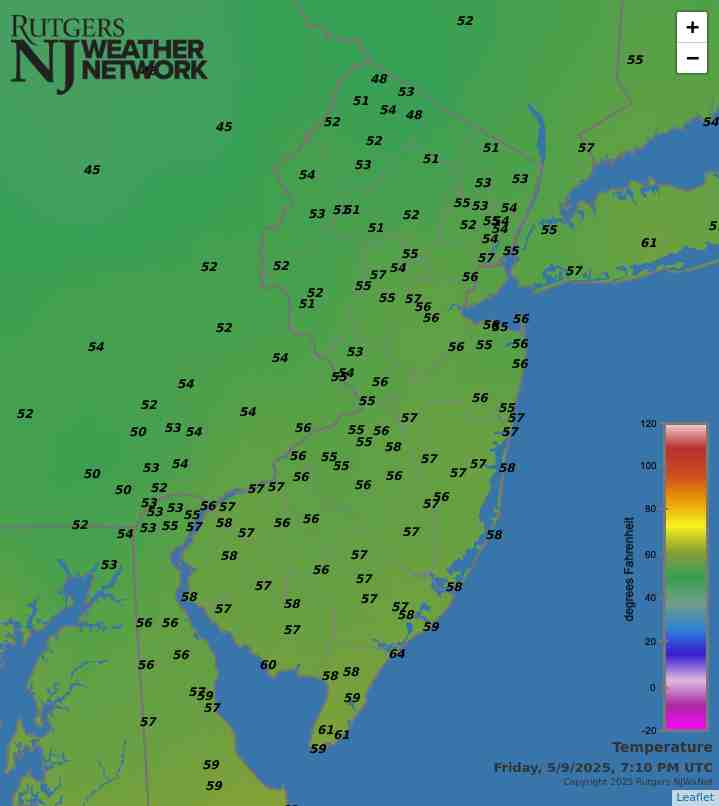
As New Jerseyans shiver through a second month of below-average temperatures and a second consecutive colder-than-average winter, it is worth seeing how the state is doing in the snowfall department this season. The brief answer is twofold: first, nowhere is it nearly as snowy as last winter, and second, this year is a tale of a state with a split snow personality.

By this time last winter, folks were talking about challenging the 1995-96 winter for top snowfall honors dating all the way back to 1895. As it turned out, the bulk of winter snow had fallen north of Interstate 195 by mid to late February, while south Jersey experienced a snowy March. Statewide, the 2013-14 winter snowfall averaged 54.3”, which was 28.2” above normal and ranked as the 7th snowiest on record. It was the 4th snowiest on record in northern counties, 6th in central NJ, and 14th in the southern third.

Wooly and a Bit Wild: January 2015 Recap

February 6, 2015 - 4:37pm -- Dave Robinson

Sea smoke photo

The first month of 2015 was a cold one with above-average precipitation. The form of the precipitation varied quite a bit at any particular location as well as across the state over the course of individual events. The statewide average temperature of 27.7° was 3.5° below normal, making it the 32nd coldest January since records commenced in 1895. Precipitation (rain and melted snow) averaged 4.78", which is 1.30" above normal and ranks as the 20th wettest January. Statewide, snowfall averaged 8.6", which is 1.5" above normal and ranks as the 41st snowiest January of the past 121 years. Storms of various intensities arrived every three days throughout the month, and included an impactful freezing rain and flooding event and two moderate snowstorms during the final two weeks. Several bitter cold episodes were punctuated by strong winds and frigid wind chills.

A Dreary Month, and Shades of Years Past: December and 2014 Annual Summary

January 5, 2015 - 9:58pm -- Dave Robinson

Coastal Flooding from Dec 9 Nor'easter

Clouds prevailed in this darkest month of the year, making for some rather persistent dreary conditions. Until the last week of the month there were only two days (the 4th and 7th) where the sun outperformed the clouds across NJ. At least the year ended on a bright note, with lots of sun during five of the last six days. With the clouds came a fair amount of precipitation, and given milder-than-normal conditions, the vast majority was in the form of rain. Statewide precipitation averaged 4.79". This is 0.88" above the 1981–2010 mean and ranks as the 27th wettest December since 1895. The mean temperature of 38.9° was 3.3° above average and ranked as the 15th warmest on record. Snowfall averaged 0.6", some 3.5" below average and ranked as the 19th least snowy December. A strong nor'easter brought strong winds, multiple inches of rain, minor to moderate coastal flooding, and beach erosion on the 9th.

ONJSC's Top 10 NJ Weather and Climate Events of 2014

January 4, 2015 - 12:00pm -- Dave Robinson

Snow removal at Metlife Stadium

Listed below is the Office of the NJ State Climatologist's ranking of the top 10 weather and climate events of 2014. More about each event can be found in the monthly narratives posted on njclimate.org. You might be tempted to rearrange the rankings, particularly as some of the events may have affected you more than others higher on the list. That's the enjoyment (and frustration!) of lists. This was the second consecutive year that was not too eventful for NJ weather and climate (goodness, we remain stunned by 2011 and 2012). Of course there is still plenty to talk about.

Winter Weather Trends: El Niño in New Jersey

December 19, 2014 - 4:41pm -- Jack McCarty

Global Sea Surface Temperature Anomalies

As we have mentioned in our past evaluations of the El Niño’s significance in the summer and fall, we are back again to analyze the wintertime impacts of a developing El Niño on New Jersey weather. An El Niño occurs when warmer-than-average waters exist in the central and eastern Pacific Ocean, specifically near the equatorial latitudes. This warming is due to a weakening of winds moving to the west, which typically transport warmer waters to the western Pacific, permitting cooler water to upwell to the surface in the east. When these winds are weaker or if they reverse direction, warm water stays in the east. The warmer sea surface temperatures in the east and the altered atmospheric flow pattern create a new dynamic between the ocean and atmosphere. The newly formed interaction sets up distinct and repetitive weather patterns across the world. No two El Niño events are alike; they vary depending on the magnitude and location of where the largest temperature anomalies are found. However, each one tends to alter weather patterns outside the overall norm.

A Cool Damp Month, and All Things Considered, a Rather Average Season: November and Fall 2014 Recap

December 7, 2014 - 7:32pm -- Dave Robinson

Wantage snow Nov 27

While cooler conditions took some time to arrive in New Jersey this fall, once here they locked in for the most part, as the November average temperature of 41.9° was 3.7° below the 1981-2010 average. This ranks as the 24th coolest November of the past 120 years. November precipitation (rain and melted snow) averaged 4.58" across the state. This is 0.94" above average and ranks as 31st wettest. On two occasions measurable snow was reported in northern and central areas, with these regions, respectively, picking up 4.6" and 1.9" on average for the month, with over a foot accumulating at higher elevations. Despite no snow accumulating in the south, the statewide average was 1.7", which is 1.3" above average. It is only the second November to average above an inch since 1995, the other in 2012. A Thanksgiving eve storm delivered a white Thanksgiving to central and northern counties.

Mild With Some Beneficial Rain: October 2014 Recap

November 3, 2014 - 4:57pm -- Dave Robinson

Waterspout photo

The tenth month of 2014 bucked the recent tendency toward dry conditions in northern New Jersey and proved to be the warmest month compared to normal since October 2013. Statewide, the October average temperature of 57.0° was 2.2° above the 1981-2010 average. This ranks as the 23rd warmest (tied with 1955) in 120 years (since records began in 1895). The average precipitation across NJ was 3.78". This is 0.15" below the mean and ranks as the 51st wettest October. Rainfall was above average in what have been some of the driest northern counties since mid summer. Still, from Mercer and Middlesex counties northward, precipitation has only been 50-75% of normal the past three months. Thus this area is still considered "abnormally dry" on the US Drought Monitor map.

El Niño Potential: Fall Impacts

October 15, 2014 - 10:12pm -- Jack McCarty

Sea Surface Temperature Anomalies

Early this past summer, we reported on the potential impacts of a developing El Niño event in the tropical Pacific on summertime weather in New Jersey. While El Niños can impact the weather worldwide, we found that New Jersey's weather doesn't fluctuate with an El Niño event. This year's summer (June-August) proved to be rather comfortable, with the statewide average temperature 0.8° below the 1981-2010 average , and precipitation 0.26” above the 1981-2010 average. These mild conditions replicated what we expect out of an El Niño summer. Now we’re back to tell you the story for the fall.

Increasingly Dry in the North: September 2014 Recap

October 6, 2014 - 3:04pm -- Dave Robinson

Dry grass

Combined with below-average precipitation in August, the northern half of New Jersey has become quite dry. Conversely, rainfall has been more common in the south, thus despite a drier-than-average September, the two-month total is slightly above average. Looking first at September, statewide precipitation averaged 2.82". This is 1.25" below the 1981-2010 average and ranks as the 46th driest September since 1895. From Hunterdon, Somerset, and Union counties northward, only 1.49" fell, which is 3.00" below average and ranks as 7th driest. The southern counties averaged 3.47", which is 0.40" below average and ranks as 56th wettest.

Heat Events in New Brunswick: A Climatological Analysis

September 16, 2014 - 1:27pm -- Jack McCarty

Heat wave photo

The summertime in New Jersey is characterized by warm temperatures that give some relief from cold and dreary wintertime conditions. However, amongst pleasant summer days, the atmosphere can align in a way that makes the heat on other days rather unbearable — something that we commonly refer to as a heat wave. Heat waves have a large impact on public health, utilities, infrastructure and more, which is why we often hear the media discussing heat waves across the nation. While heat waves may call for a day at the beach, they're also a cause for public concern.

Pages

Subscribe to Front page feed