

Overview
Mother Nature had plenty of tricks up her sleeve this month and brought about a dynamic mix of weather across New Jersey in July. There was no shortage of things to talk about, including an oppressive and dangerous heat wave, rounds of severe weather, multiple flash flooding events, and a notable stretch of poor air quality stemming from wildfires burning in Canada.
Sadly, the preliminary count indicates that 33 New Jerseyans lost their lives as a result of the weather. The New Jersey Department of Health reported 29 heat-related fatalities early in the month. A man was killed when a large tree fell on his vehicle in Scotch Plains during the storms on July 3. A construction worker was struck and killed by lightning in Monroe Township, and two children died while playing near the Passaic River on July 29.
These tragedies remind us all of the importance of heeding severe weather warnings. In July, the National Weather Service issued a total of 174 severe thunderstorm, flash flood, and tornado warnings for the state – more than double the average number issued in July over the last 10 years (Figure 1). Of particular note is the nearly 3X increase in the number of flash flood warnings issued statewide. Low-level wind shear associated with frequent warm-frontal passages also led to an elevated tornado threat and 12 tornado warning issuances this month.
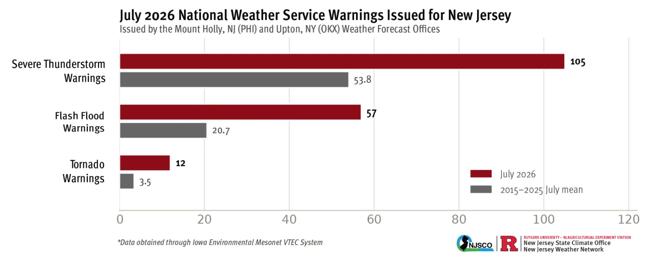
Figure 1. National Weather Service warnings issued by the Mount Holly, NJ, and Upton, NY, Weather Forecast Offices that impacted New Jersey in July (red) compared to the most recent 10-year average warning frequency in July (gray).
Thirteen NJWxNet Mesonet, SafetyNet, and USGS precipitation gages registered peak 1-hour rainfall events in excess of 2” (Table 1). These high rainfall rates are of concern for stormwater management and flash flooding risk as it is difficult for the ground to absorb the rainfall falling over a short period of time. The highest 1-hour rainfall was 3.21” inches in one hour at Upper Deerfield in Cumberland County on the morning of July 6. The other events occurred at various locations across the state and at different times throughout the month, illustrating the widespread impact of these intense rainfall rates.
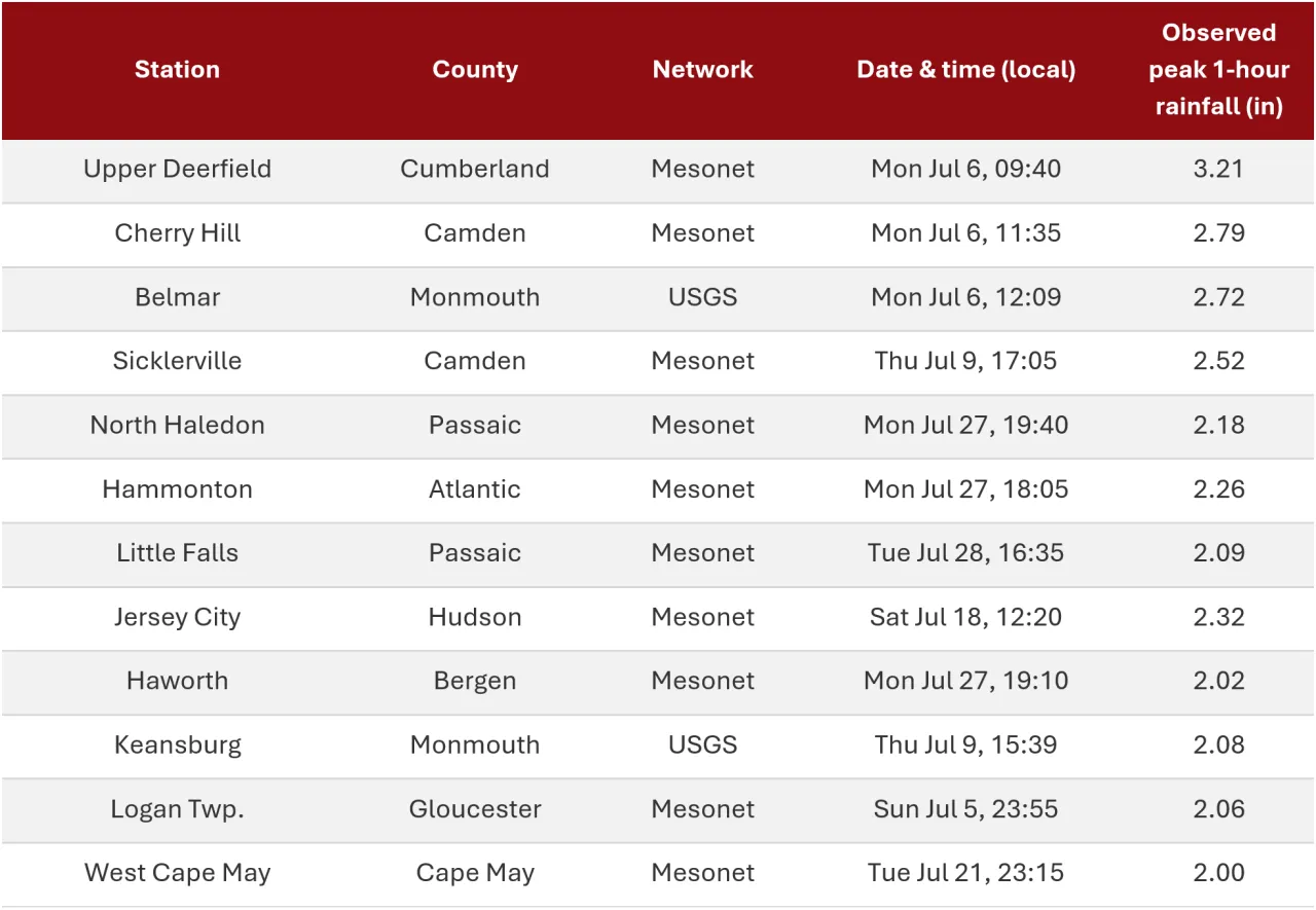
Table 1. Peak 1-hour rainfall amounts observed among NJWxNet, SafetyNet, and USGS stations during July 2026.
The flash flooding threat was also consistent with this, marking the first above-average precipitation month since July 2025. Statewide, NJ saw 6.43” of precipitation (1.72” above average, 18th wettest). The Northern division led the way with 7.10” (2.38” above average, 20th wettest), followed by the Southern division at 6.10” (1.36” above average, 23rd wettest), and the Coastal division at 5.23” (0.85” above average, 37th wettest).
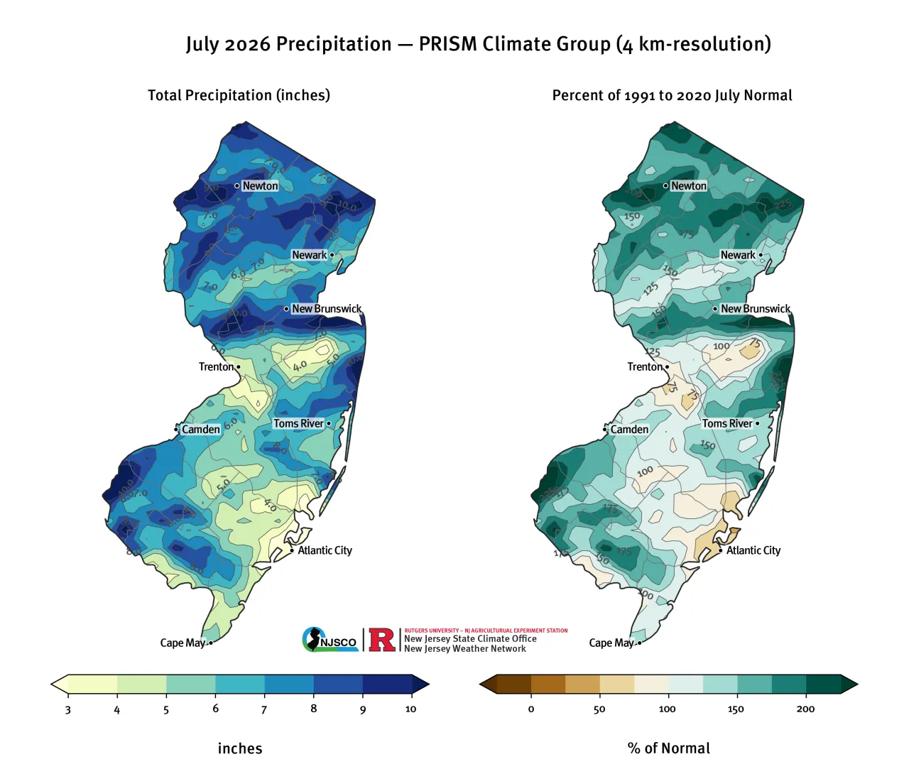
Figure 2. July 2026 total precipitation (left) and departure from 30-year monthly climatology (right) from PRISM (Oregon State, https://prism.oregonstate.edu).
The rain was welcome from a drought perspective. By the end of the month, 29.35% of the state was in either severe or extreme drought (US Drought Monitor categories D2 and D3), compared to 67.93% on June 30 (Figure 3). Consistent with the precipitation patterns, much of this improvement occurred in the Highlands and along the Delaware River in southwestern New Jersey.
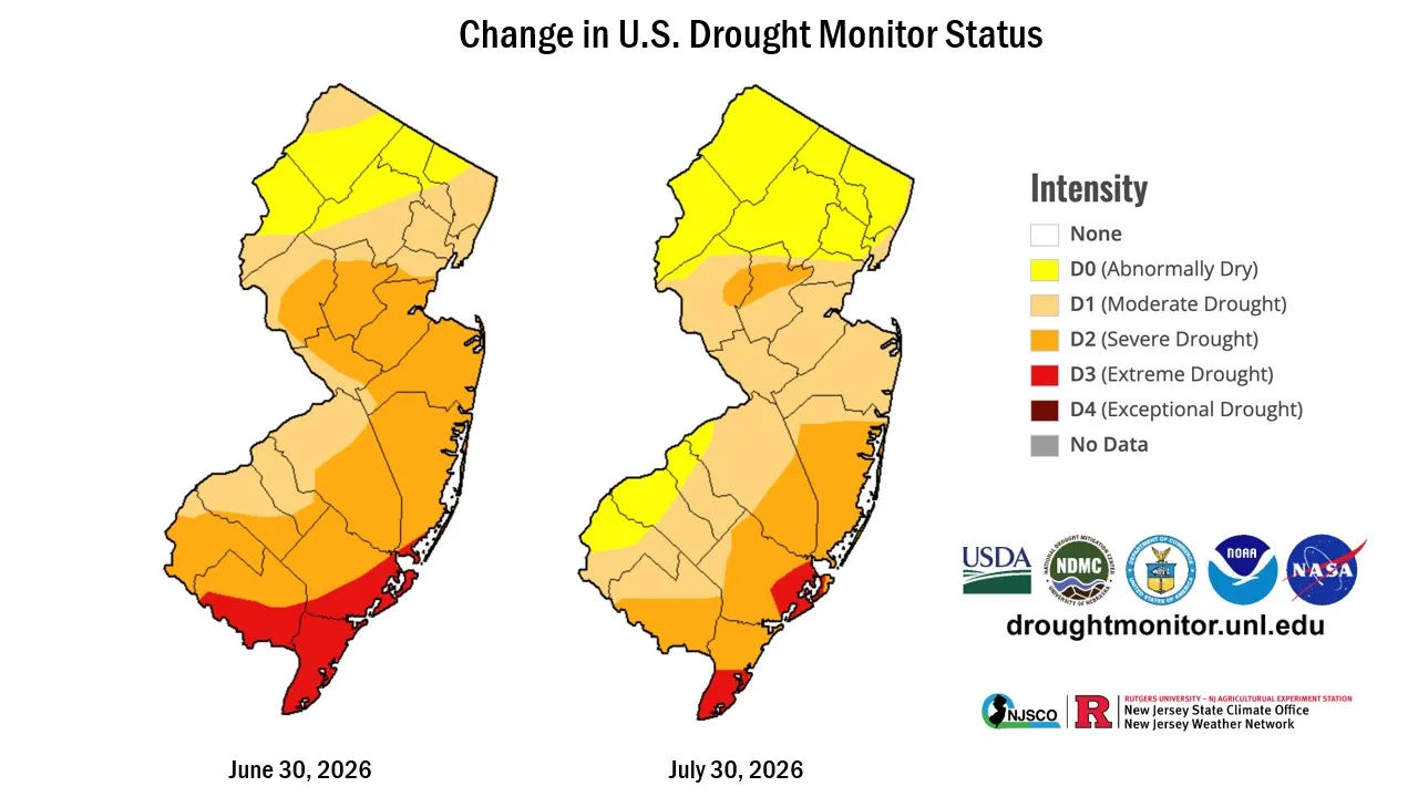
Figure 3. Change in U.S. Drought Monitor Status from June 30 to July 30, 2026.
Storms and Precipitation
July 1 through July 4
During the heatwave, widely scattered pop-up showers and storms occurred on July 1, which produced only a few hundredths of an inch of precipitation, and the weather around the state was dry on July 2. The evening of July 3 brought widespread severe weather to the central and northern parts of the state.
Heavy thunderstorms developed over the Poconos late in the afternoon and early evening before moving from northwest to southeast across the state. A strong gust front developed ahead of the line of storms and brought damaging winds. A peak wind gust of 71 mph was recorded at Newark Liberty International Airport. The NJWxNet station in East Brunswick recorded a wind gust of 50 mph. Closer to the coast, Oceanport also recorded a peak wind gust of 50 mph, and Sea Girt reached 64 mph. Generally, about 0.25” to 1.00” of rain fell in the northern half of the state. Some of the higher amounts from CoCoRaHS reports included Rockaway (0.98”), Little Falls (0.91”), and Montclair (0.90”).
On Independence Day, it was South Jersey’s turn for severe weather. A line of storms developed near Washington, DC, and moved east across the Chesapeake Bay, the Eastern Shore of MD, and Northern DE. As they crossed Delaware Bay into southwestern New Jersey, another strong gust front preceded the line of storms (Figure 4). The Mesonet station at Lower Alloways Creek recorded a 58-mph wind gust during the storms. Other notable wind gusts were at Fortescue (57 mph), Berkeley Township and Little Egg Harbor (55 mph), and Sea Girt (51 mph). Rainfall was more widespread throughout the state on July 4, which put a damper on some fireworks displays, with the largest amounts in the central counties. East Windsor saw the most rain at 1.67”. Other stations reporting over an inch of rain included Jackson (1.34”), Point Pleasant (1.14”), Pennington (1.09”), and Hamilton (1.06”).
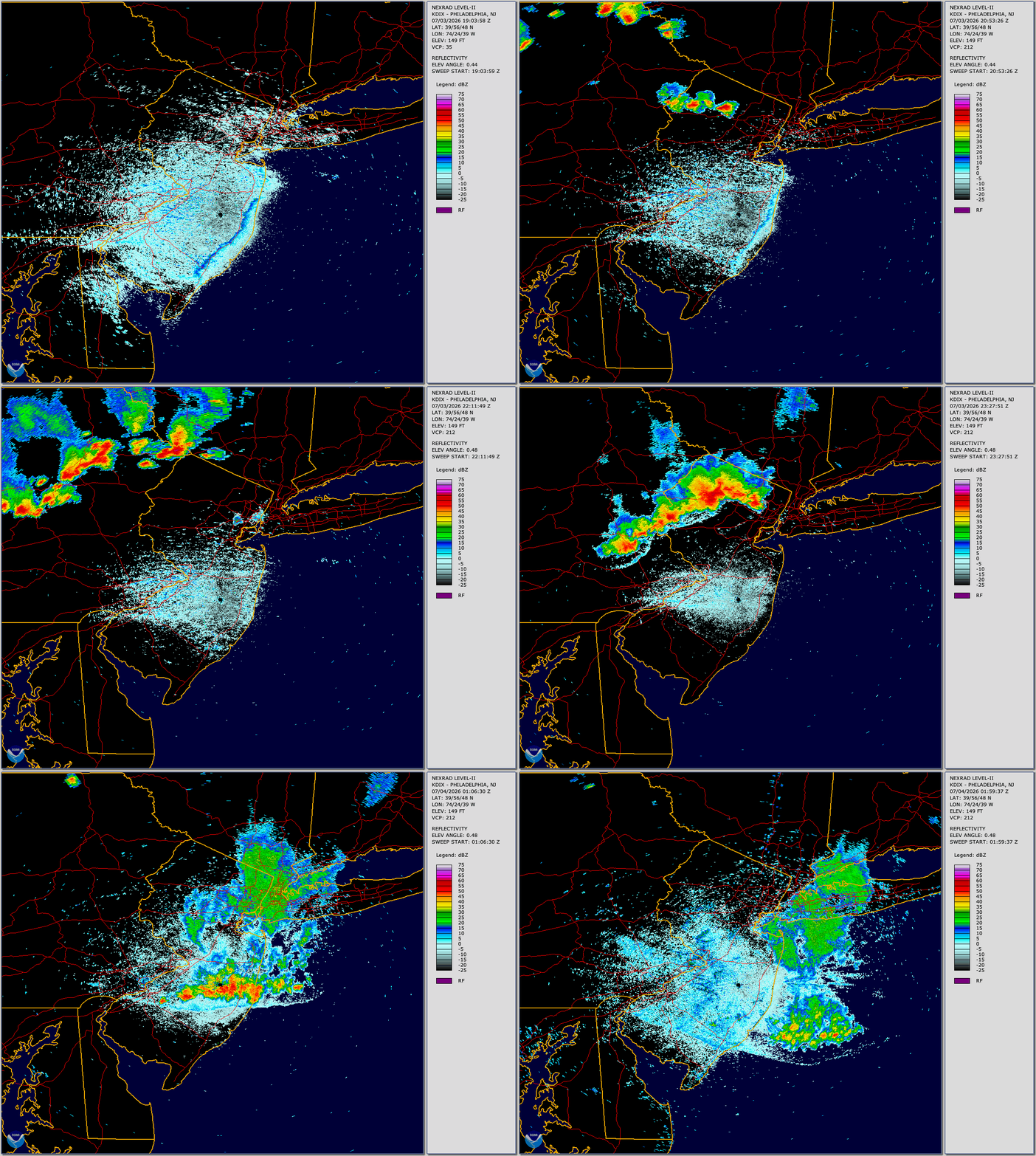
Figure 4. Animation of the July 3 squall line from the NWS radar site at Fort Dix, NJ (KDIX).
July 5 and 6
The heatwave finally broke with widespread showers and storms, leading to extreme rainfall totals and flash flooding. The storms arrived in the evening hours of July 5 and lasted through the following day. Hardest hit was southern Monmouth County, where two-day rain totals of 2” to 5”+ fell along the coast from Long Branch south to Belmar. Neptune was especially hard with multiple reports of rainfall exceeding 4” while a CoCoRaHS observer in Long Branch measured 5.13”. The heavy rains also caused multiple flash flood warnings and triggered a roof collapse at a store in Ocean Township. Areas in Gloucester, Camden, and Burlington counties also saw heavy rain (2” to 4”) and flooding. 4.36” of rain fell in Collingswood, 3.86” in Cherry Hill, and 3.36” in Barrington.
July 9
Widely scattered but intense thunderstorms with torrential rain returned again on Thursday. Hardest hit was the Route 1/Route 27 corridor in Somerset and Middlesex counties. Impressive rainfall totals were recorded in Franklin Township (4.41”), South Brunswick (4.26”), and Hillsborough (4.13”). Intense rain fell in New Brunswick, resulting in flooding along Route 18 and triggering several water rescues. More storms dumped 2” to 4” along the Delaware River and interior Cumberland County.
July 11
A weak wave of low pressure and a stalled cold front over Delmarva produced showers and storms along the AC Expressway. Generally, 0.50” to 1.00” with localized amounts up to 1.50”. Two notable exceptions were the CoCoRaHS site in Woodland Township 4.79” and two gages in Woodbine (2.48” and 2.72”), where the sea breeze front enhanced the precipitation locally. The storms also produced some isolated wind damage and localized road flooding in parts of Gloucester County.
July 15 and 16
Showers and storms developed over the Poconos and Highlands in the late afternoon and drifted southeastward across the northern third of the state. Rainfall amounts were typical with afternoon summer thunderstorms, ranging from 0.25” to 0.50”, mostly in Morris, Essex, Union, and southern Passaic counties. The outflow boundary continued to drift south and stalled over Burlington and Ocean counties. This set the stage for storm enhancement the following day. Storms moved into western Burlington County around 4 PM and traveled east-southeastward toward the coast. Back-building and training thunderstorms impacted southern Ocean County from 5 PM to 9 PM, producing intense rainfall that caused flash flooding. Hardest hit was Stafford Township with 3” to 4” of rainfall, while Surf City on Long Beach Island measured 4.37” (Figure 5). The state's largest hail report of the month (1.5”) occurred at Warren Grove during this event.
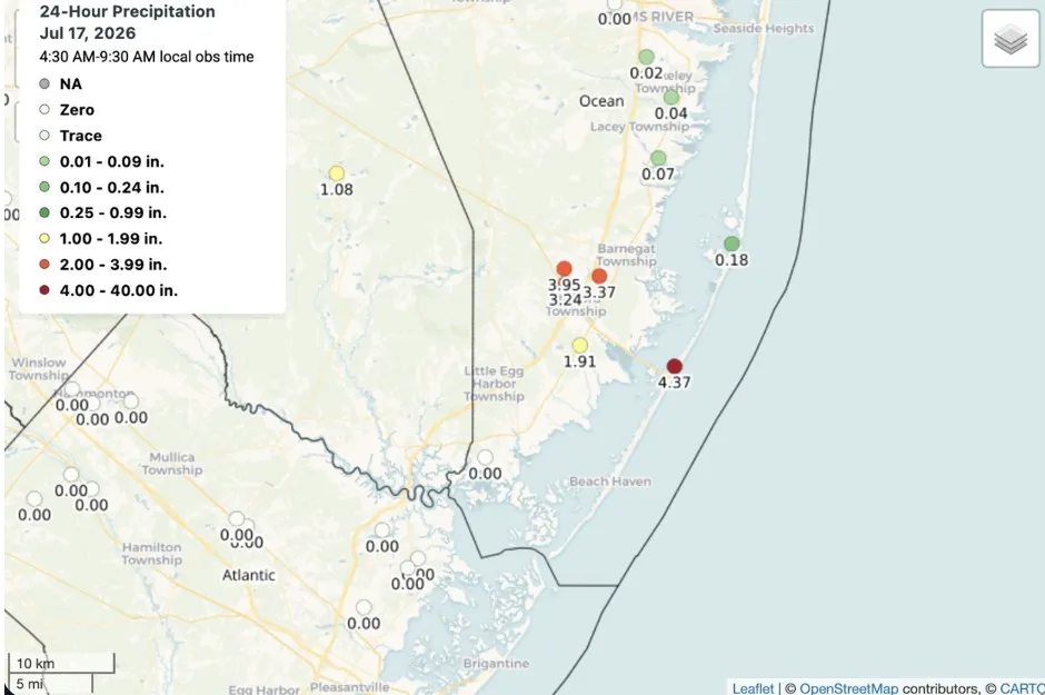
Figure 5. CoCoRaHS observations of rainfall in Southern Ocean County that fell on the afternoon of July 16.
July 18
After a one-day respite, the storm-weary state braced for another widespread storm and severe weather event, which had been well publicized in advance by forecasters. The forecasted tornado threat was the leading headline. Rain began falling across the southern part of the state just after sunrise. Later in the morning, a heavy band of showers moved through the I-80 corridor, producing intense rainfall. As the storms pushed east, they continued to produce 1”/hour rain rates, especially in Jersey City and Newark, prompting water rescues. A second area of heavy rain initially formed over Hunterdon County and moved east into Somerset, Middlesex, and Monmouth counties by early afternoon. This area ended up receiving the most rainfall in the state, with the highest totals of 1.50” to 3.00” in Southern Middlesex and northern Monmouth counties (Figure 6). Numerous reports of flooding and road closures were made during this rain, including Route 287 in Bridgewater, Route 440 in Perth Amboy, and US-9 and Route 35 in Old Bridge.
At 3 PM, a Tornado Watch was issued for most of the state (except the northeast corner). Unfortunately, the KDIX radar site went offline around this time due to a lightning strike. A waterspout sighting was reported off the coast near Asbury Park and Ocean Grove, but the state was spared from the forecasted tornadoes. There were some reports of downed trees and wires, especially near Hamilton Square and Lakehurst.
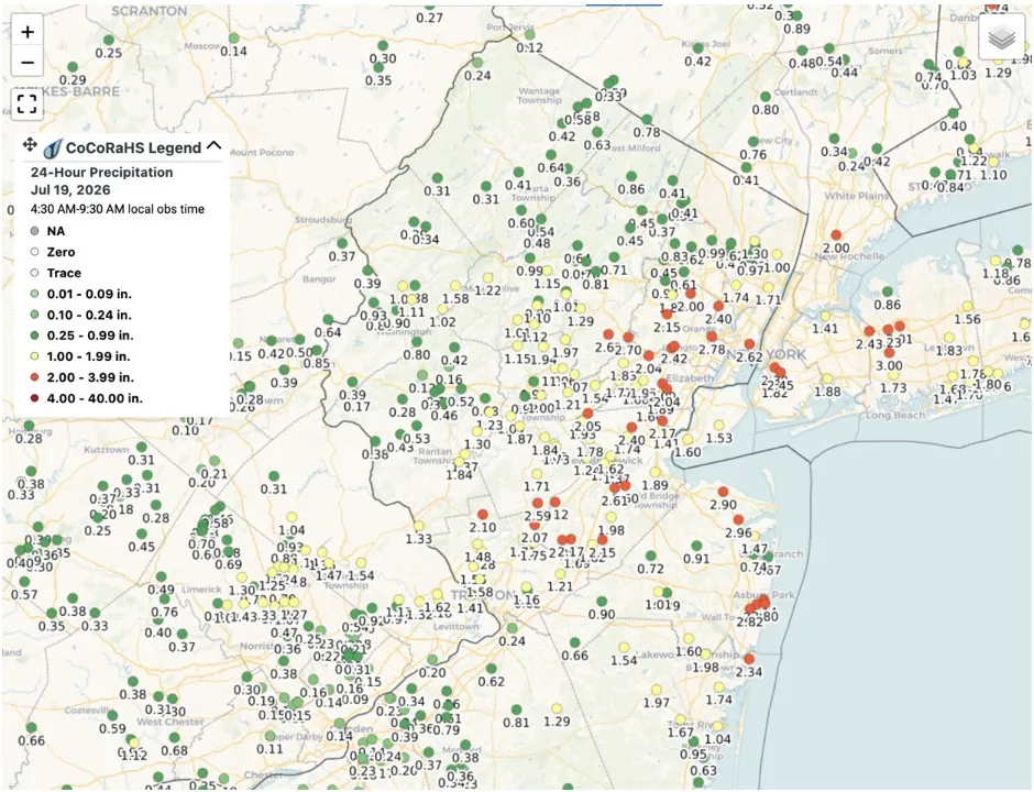
Figure 6. CoCoRaHS observations of rainfall in northern New Jersey that fell during the July 18 event.
July 21
More active weather returned in the form of morning showers and storms across the northwest part of the state. After a brief pause, storms fired again in the early afternoon along the I-80 corridor, and some of these storms spawned tornadoes in Morris County. The last time Morris County had confirmed tornadoes was in August of 2021, when similar magnitude storms struck the county. By early afternoon, most areas along the I-80 corridor received between 2” and 3” of rainfall (Figure 7).
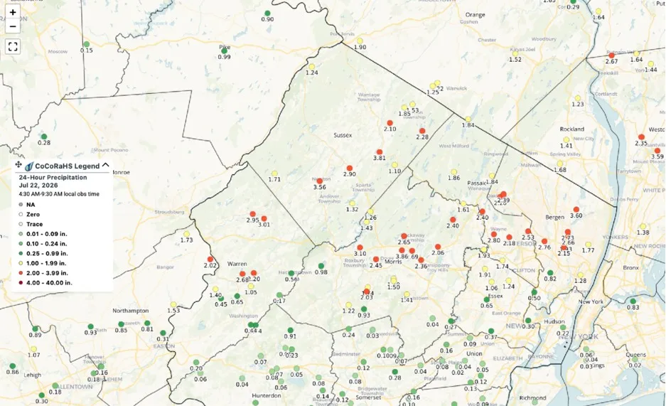
Figure 7. CoCoRaHS observations of rainfall around and along the I-80 corridor that fell on the afternoon of July 21.
Later in the afternoon, supercell thunderstorms formed over central Delaware as a more coherent line of storms moved through the Philadelphia suburbs. A well-defined waterspout was observed over Delaware Bay and moved ashore in Cape May, causing the third confirmed tornado event of the day in the state. The drought-stricken southern half of Cape May County received much-needed 2” to 4” with these late-afternoon storms.
July 27 through July 30
A large, slow-moving upper-level low brought unsettled weather for the final week of July. Widely scattered but intense storms with heavy rain returned across the state on Monday. Hammonton was especially hard hit. The Hammonton NJWxNet station recorded 2.26” of rain in one hour. “Catastrophic” flooding was reported to homes along Route 54, with reports of vehicles being nearly submerged in flash flood waters. Eastern Passaic, Bergen, and Hudson counties also saw impressive rainfall on Monday, leading to flash flooding. Notable totals from CoCoRaHS observers included 3.65” in River Edge, 2.87” in Hawthorne, and 2.54” in Fairlawn.
A repeat performance of Monday’s rain also occurred on Tuesday in areas near Patterson and Hackensack. Two-day totals in this part of the state generally exceeded 4”, with River Edge (6.06”) and Hawthorne (5.46”) being the standouts. The New Milford Fire Department reported more than 20 stranded-vehicle calls, and the Paterson Fire Department rescued 20 motorists, according to local storm reports submitted to the National Weather Service. There were also reports of several feet of water in some basements in Bergenfield. The heavy rain on Tuesday afternoon was more widespread throughout the state, but once again, the I-80 corridor saw the worst weather. Areas along the Musconetcong River saw 4"–6” of rain – a month's worth of rain – in one day. The most impressive totals were 6.94” in Washington Township and 6.23” in Holland Township.
Widely scattered but much lighter showers persisted on Wednesday and Thursday before the upper low finally exited the region.

A vehicle trapped in flood waters in Glen Rock on July 27. Photo by Boyd Loving.
Figure 8. A vehicle trapped in flood waters in Glen Rock on July 27. Photo by Boyd Loving.
Temperatures
July 2026's statewide average temperature of 75.8°F was 0.4° above normal and ranked as the 28th warmest of the past 132 Julys. The average high of 86.0° was 0.3° above normal, ranking as the 33rd warmest, while the average low of 65.6° was 0.5° above normal and 24th warmest. The Northern climate division averaged 73.6° (-0.1°, 34th warmest), the Southern division 77.2° (+0.7°, 22nd warmest), and the Coastal division 76.9° (+0.7°, 19th warmest).
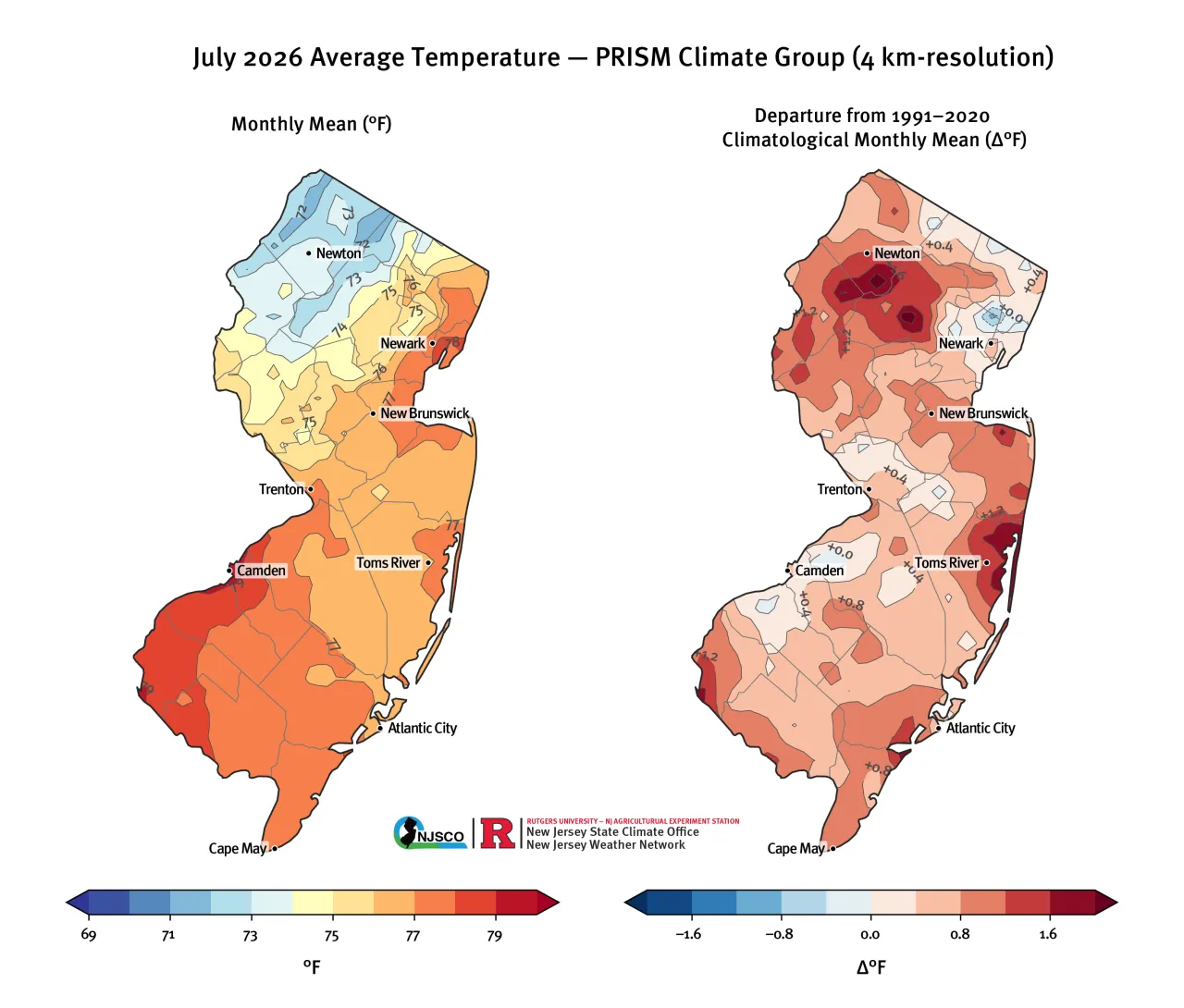
Figure 9. July 2026 average temperature (left) and departure from 30-year monthly climatology (right) from PRISM (Oregon State, https://prism.oregonstate.edu).
The month began with one of New Jersey’s most intense heat waves. The temperature reached a high of 105° at Newark Liberty International Airport on July 3, just 3° shy of the all-time record of 108° set in 2011. There were numerous readings exceeding 100° on multiple days at NJWxNet and NWS Cooperative Observer stations across the state. The Atlantic City International Airport, located inland in Pomona, tied an all-time record high of 106° on July 4, matching the old record of 106° set on June 28, 1969. A strong off-shore flow and a lack of a sea breeze during this heat wave meant little relief from the heat could be found at the beaches, with the Atlantic City Marina also reaching 100°.
During prolonged periods of heat stress, warm overnight temperatures become an added concern when they prevent our bodies from cooling off. The period from Thursday, July 2, to Friday, July 3, was one of the warmest nights in our state’s history. The overnight low at Newark’s Liberty International Airport was only 87°. This would have set a new statewide record for the warmest daily minimum temperature had it not been for the severe thunderstorms late Friday evening, which dropped temperatures into the lower 80s.
New Jersey saw another heatwave towards the middle of the month. Average temperatures from July 13 through July 19 were about 2° above normal across all of New Jersey's three climate divisions, according to NJWxNet observations. The heat wave peaked on Wednesday, July 15, with several 100° readings statewide. Temperatures remained in the 90°s on Thursday and Friday before cooling significantly into the weekend. The week's hottest temperature was 101° in Bayville on Wednesday. Atlantic City Airport and the NJWxNet station in Berkeley Township also reached 100°.
The mid-month heatwave was also accompanied by the state’s worst air quality since 2023. Smoke from wildfires burning in Western Ontario was initially brought into the region by a northwesterly flow aloft beginning on Tuesday, July 14, and intensified in the wake of a surface cold front that crossed the state Wednesday into Thursday. Thursday brought the most widespread dense smoke of the event, hourly Air Quality Index (AQI) values exceeding 200, and visibility dropping below 3 miles at several New Jersey ASOS locations. While the smoke eased slightly on Friday, air quality remained poor before improving on Saturday.

Figure 10. Smoke-tinted skies over Lawrence Township in the evening on July 15.
Following the passage of an upper-level trough and associated surface frontal complex moving through the state on Tuesday July 21, a broad area of Canadian high pressure dominated the weather pattern across the state for the remainder of the week. Average temperatures that week were about 4° below normal across all of New Jersey’s climate divisions, according to NJWxNet observations. The cooler average temperatures were driven by unseasonably cool overnight lows in the Highlands and Kittatinny Valley, where overnight lows in the 40s were observed: Monday (45° in Walpack and Sandyston), Thursday (49° in Walpack), and Friday mornings (48° in Walpack and Sandyston). Overnight lows in the upper 60°s were common on most nights in coastal regions under the marine influence.