
Delays Abound: October 2017 Summary
The tenth month of 2017 was marked by the slow arrival of October-like conditions, including the first freezes of the season, the close-to-two week delay in the fall leaf season, and the absence of much precipitation until two late-month storms made up for lost time. Amidst all of this, October proved to be the second warmest across New Jersey since the onset of records in 1895. The 60.7° average was 6.2° above the 1981–2010 normal, trailing the 2007 record by 1.4°, but 0.9° above the now third mildest October in 1971. The month ended with a large portion of the state yet to be visited by the first freeze of the season.
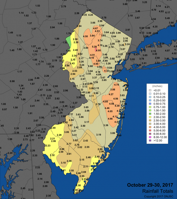
Rainfall was rather limited throughout the first three weeks of the month, leading to an expansion of D0 “abnormally dry” conditions across the northern half of the state in the US Drought Monitor. It was anticipated that a portion of the north would move to a D1 “moderate drought” designation and the remainder of NJ to D0 come the October 31st weekly map (as mentioned in previous reports, the state climate office plays a significant role in making such designations). However, some welcome rain fell on the 24th, and on the 29th the largest statewide rain event since April 30, 2014, brought close to, and in some areas more than, a month’s worth of liquid in a major storm. This arrived on the 5th anniversary of Sandy and 6th anniversary of a historic early season snowstorm. When all was said and done, statewide October precipitation averaged 4.96”. This is 1.07” above average and ranks as the 25th wettest of the past 123 years.
